Arnoldsburg Topo Map West Virginia
To zoom in, hover over the map of Arnoldsburg
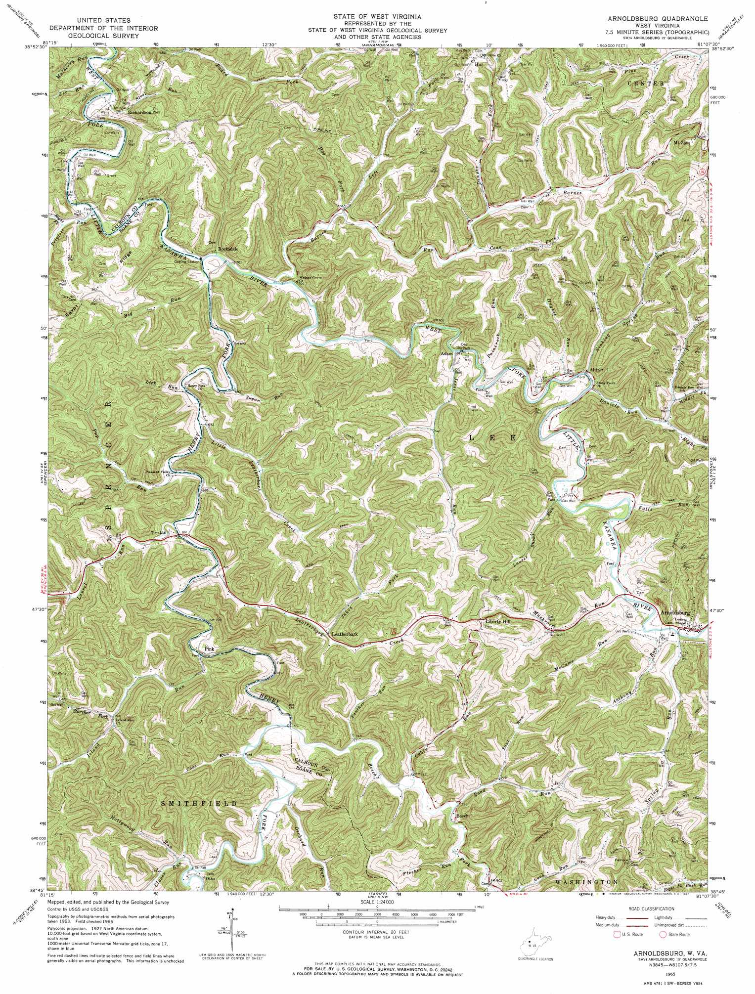
USGS Topo Quad 38081g2 - 1:24,000 scale
| Topo Map Name: | Arnoldsburg |
| USGS Topo Quad ID: | 38081g2 |
| Print Size: | ca. 21 1/4" wide x 27" high |
| Southeast Coordinates: | 38.75° N latitude / 81.125° W longitude |
| Map Center Coordinates: | 38.8125° N latitude / 81.1875° W longitude |
| U.S. State: | WV |
| Filename: | o38081g2.jpg |
| Download Map JPG Image: | Arnoldsburg topo map 1:24,000 scale |
| Map Type: | Topographic |
| Topo Series: | 7.5´ |
| Map Scale: | 1:24,000 |
| Source of Map Images: | United States Geological Survey (USGS) |
| Alternate Map Versions: |
Arnoldsburg WV 1965, updated 1967 Download PDF Buy paper map Arnoldsburg WV 2011 Download PDF Buy paper map Arnoldsburg WV 2014 Download PDF Buy paper map Arnoldsburg WV 2016 Download PDF Buy paper map |
1:24,000 Topo Quads surrounding Arnoldsburg
Elizabeth |
Girta |
Macfarlan |
Smithville |
Burnt House |
Reedy |
Burning Springs |
Annamoriah |
Grantsville |
Tanner |
Peniel |
Spencer |
Arnoldsburg |
Millstone |
Normantown |
Walton |
Looneyville |
Tariff |
Chloe |
Rosedale |
Kettle |
Clio |
Newton |
Ivydale |
Strange Creek |
> Back to 38081e1 at 1:100,000 scale
> Back to 38080a1 at 1:250,000 scale
> Back to U.S. Topo Maps home
Arnoldsburg topo map: Gazetteer
Arnoldsburg: Populated Places
Adam elevation 211m 692′Altizer elevation 219m 718′
Arnoldsburg elevation 225m 738′
Beech elevation 227m 744′
Hur elevation 350m 1148′
Leatherbark elevation 233m 764′
Liberty Hill elevation 322m 1056′
Otto elevation 236m 774′
Pink elevation 218m 715′
Richardson elevation 210m 688′
Rocksdale elevation 206m 675′
Tristan elevation 220m 721′
Arnoldsburg: Springs
McCoy Spring elevation 260m 853′Arnoldsburg: Streams
Anthony Run elevation 221m 725′Barnes Run elevation 207m 679′
Beech Fork elevation 213m 698′
Big Run elevation 206m 675′
Board Fork elevation 211m 692′
Cabin Run elevation 220m 721′
Clover Run elevation 220m 721′
Coon Fork elevation 230m 754′
Cove Run elevation 215m 705′
Daniels Run elevation 212m 695′
Dennis Fork elevation 234m 767′
Falls Run elevation 218m 715′
Flesher Run elevation 225m 738′
Henry Fork elevation 205m 672′
Hog Fork elevation 216m 708′
Hollywood Run elevation 226m 741′
Hughes Run elevation 212m 695′
Island Run elevation 214m 702′
Jakes Fork elevation 234m 767′
Jesse Run elevation 211m 692′
Laurel Run elevation 214m 702′
Laurel Shoal Run elevation 216m 708′
Leatherbark Creek elevation 211m 692′
Lee Run elevation 203m 666′
Left Fork Barnes Run elevation 215m 705′
Lick Run elevation 207m 679′
Little Leatherbark Creek elevation 208m 682′
McCume Run elevation 219m 718′
Middle Fork Daniels Run elevation 221m 725′
Mulberry Run elevation 198m 649′
Mushroom Run elevation 217m 711′
Orchard Run elevation 218m 715′
Paintrock Run elevation 210m 688′
Panther Run elevation 225m 738′
Pup Run elevation 209m 685′
Right Fork Daniels Run elevation 223m 731′
Right Fork Triplett Run elevation 203m 666′
Road Run elevation 220m 721′
Saul Run elevation 235m 770′
Sinking Spring Run elevation 212m 695′
Spring Run elevation 221m 725′
Starcher Fork elevation 234m 767′
Steel Run elevation 200m 656′
Sugar Run elevation 206m 675′
Triplett Run elevation 203m 666′
Arnoldsburg digital topo map on disk
Buy this Arnoldsburg topo map showing relief, roads, GPS coordinates and other geographical features, as a high-resolution digital map file on DVD:
Western Virginia & Southern West Virginia
Buy digital topo maps: Western Virginia & Southern West Virginia