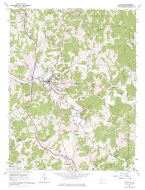
Ripley Topo Map West Virginia
To zoom in, hover over the map of Ripley
USGS Topo Quad 38081g6 - 1:24,000 scale
| Topo Map Name: | Ripley |
| USGS Topo Quad ID: | 38081g6 |
| Print Size: | ca. 21 1/4" wide x 27" high |
| Southeast Coordinates: | 38.75° N latitude / 81.625° W longitude |
| Map Center Coordinates: | 38.8125° N latitude / 81.6875° W longitude |
| U.S. State: | WV |
| Filename: | o38081g6.jpg |
| Download Map JPG Image: | Ripley topo map 1:24,000 scale |
| Map Type: | Topographic |
| Topo Series: | 7.5´ |
| Map Scale: | 1:24,000 |
| Source of Map Images: | United States Geological Survey (USGS) |
| Alternate Map Versions: |
Ripley WV 1960, updated 1963 Download PDF Buy paper map Ripley WV 1960, updated 1976 Download PDF Buy paper map Ripley WV 2011 Download PDF Buy paper map Ripley WV 2014 Download PDF Buy paper map Ripley WV 2016 Download PDF Buy paper map |
1:24,000 Topo Quads surrounding Ripley
> Back to 38081e1 at 1:100,000 scale
> Back to 38080a1 at 1:250,000 scale
> Back to U.S. Topo Maps home
Ripley topo map: Gazetteer
Ripley: Airports
Dickirson Heliport elevation 219m 718′Ripley: Crossings
Interchange 132 elevation 238m 780′Interchange 138 elevation 184m 603′
Ripley: Dams
Cedar Lakes Dam Number One elevation 185m 606′Cedar Lakes Dam Number Two elevation 192m 629′
Halls Farm Pond Dam elevation 263m 862′
Jackson County Livestock Pond Number One Dam elevation 259m 849′
Ripley: Parks
Cedar Lakes State Recreation Center elevation 230m 754′Ripley: Populated Places
Fairplain elevation 230m 754′Mentor (historical) elevation 263m 862′
Oak Hill elevation 279m 915′
Parchment Valley elevation 187m 613′
Ripley elevation 187m 613′
Salt Hill elevation 282m 925′
Shatto elevation 192m 629′
Sidneyville elevation 219m 718′
Skidmore elevation 189m 620′
Ripley: Ridges
Southall Ridge elevation 305m 1000′Stone Ridge elevation 243m 797′
Zion Ridge elevation 303m 994′
Ripley: Streams
Almon Run elevation 188m 616′Bear Fork elevation 197m 646′
Boar Run elevation 188m 616′
Buffalolick Run elevation 189m 620′
Bullfrog Run elevation 179m 587′
Burnt Run elevation 222m 728′
Burnt Run elevation 179m 587′
Claylick Run elevation 177m 580′
Cox Fork elevation 183m 600′
Elk Fork elevation 186m 610′
Fourmile Run elevation 187m 613′
Grass Run elevation 196m 643′
Grass Run elevation 183m 600′
Kissel Run elevation 188m 616′
Left Fork Sycamore Creek elevation 179m 587′
Little Grass Run elevation 196m 643′
Little Mill Creek elevation 186m 610′
Stationcamp Run elevation 187m 613′
Straight Run elevation 188m 616′
Sycamore Creek elevation 178m 583′
Tug Fork elevation 181m 593′
Wolf Run elevation 193m 633′
Wolfpen Run elevation 185m 606′
Ripley: Summits
Hargreave Knob elevation 295m 967′Reynolds Hill elevation 304m 997′
Ripley: Valleys
Simpson Hollow elevation 195m 639′Ripley digital topo map on disk
Buy this Ripley topo map showing relief, roads, GPS coordinates and other geographical features, as a high-resolution digital map file on DVD:
Western Virginia & Southern West Virginia
Buy digital topo maps: Western Virginia & Southern West Virginia


