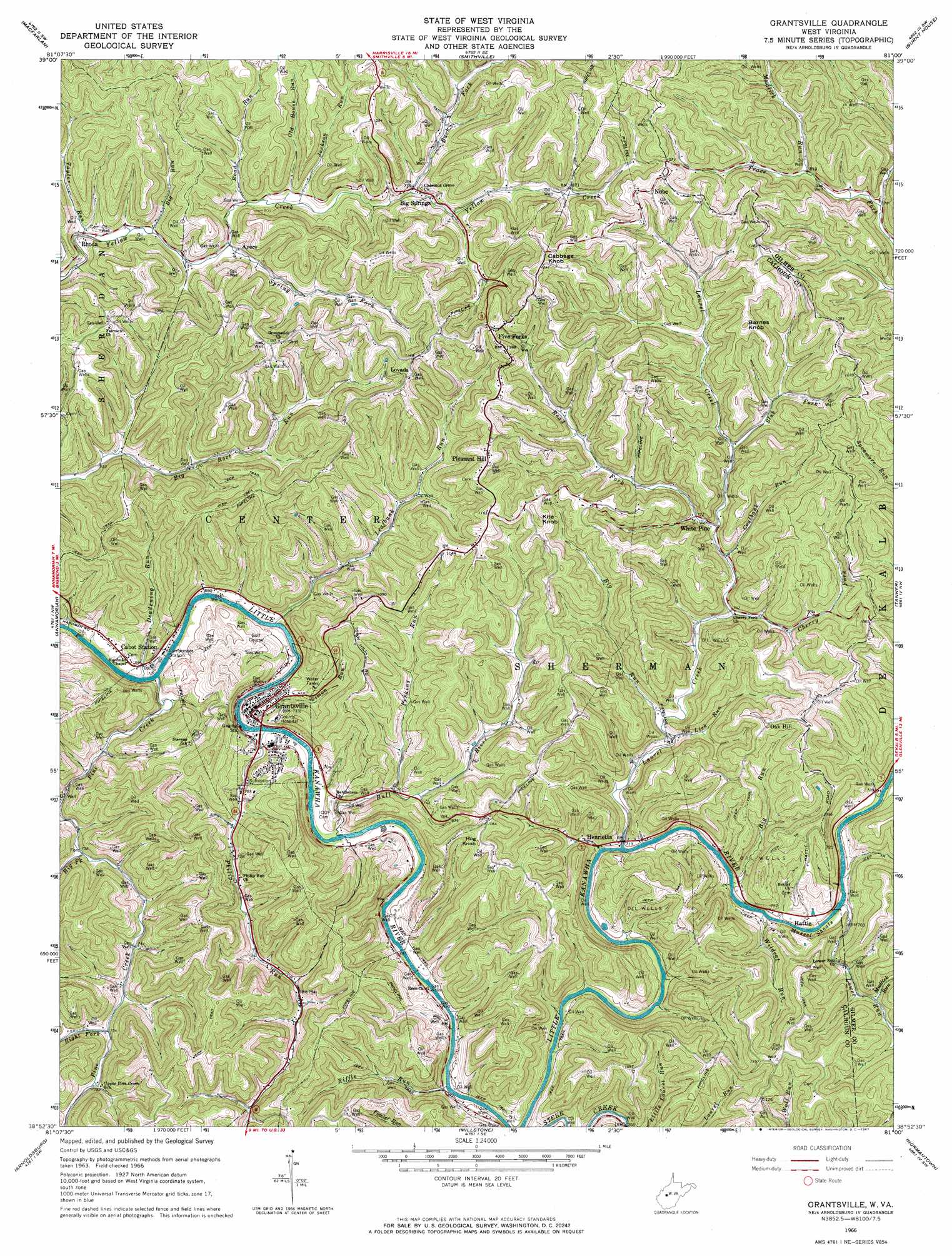
Grantsville Topo Map West Virginia
To zoom in, hover over the map of Grantsville
USGS Topo Quad 38081h1 - 1:24,000 scale
| Topo Map Name: | Grantsville |
| USGS Topo Quad ID: | 38081h1 |
| Print Size: | ca. 21 1/4" wide x 27" high |
| Southeast Coordinates: | 38.875° N latitude / 81° W longitude |
| Map Center Coordinates: | 38.9375° N latitude / 81.0625° W longitude |
| U.S. State: | WV |
| Filename: | o38081h1.jpg |
| Download Map JPG Image: | Grantsville topo map 1:24,000 scale |
| Map Type: | Topographic |
| Topo Series: | 7.5´ |
| Map Scale: | 1:24,000 |
| Source of Map Images: | United States Geological Survey (USGS) |
| Alternate Map Versions: |
Grantsville WV 1966, updated 1967 Download PDF Buy paper map Grantsville WV 2011 Download PDF Buy paper map Grantsville WV 2014 Download PDF Buy paper map Grantsville WV 2016 Download PDF Buy paper map |
1:24,000 Topo Quads surrounding Grantsville
Petroleum |
Cairo |
Harrisville |
Pullman |
Oxford |
Girta |
Macfarlan |
Smithville |
Burnt House |
Auburn |
Burning Springs |
Annamoriah |
Grantsville |
Tanner |
Glenville |
Spencer |
Arnoldsburg |
Millstone |
Normantown |
Cedarville |
Looneyville |
Tariff |
Chloe |
Rosedale |
Gassaway |
> Back to 38081e1 at 1:100,000 scale
> Back to 38080a1 at 1:250,000 scale
> Back to U.S. Topo Maps home
Grantsville topo map: Gazetteer
Grantsville: Bars
Mussel Shoals elevation 213m 698′Grantsville: Bridges
Little Kanawha River Bridge elevation 204m 669′Grantsville: Populated Places
Ayers elevation 227m 744′Big Springs elevation 235m 770′
Cabot Station elevation 209m 685′
Five Forks elevation 337m 1105′
Grantsville elevation 217m 711′
Hattie elevation 220m 721′
Henrietta elevation 215m 705′
Index (historical) elevation 261m 856′
Lovada elevation 334m 1095′
Nobe elevation 339m 1112′
Oak Hill elevation 342m 1122′
Pleasant Hill elevation 360m 1181′
Rhoda elevation 216m 708′
White Pine elevation 240m 787′
Grantsville: Post Offices
Big Springs Post Office elevation 242m 793′Five Forks Post Office elevation 357m 1171′
Nobe Post Office elevation 335m 1099′
Grantsville: Streams
Back Fork elevation 232m 761′Big Fork elevation 214m 702′
Big Run elevation 214m 702′
Big Run elevation 207m 679′
Big Run elevation 217m 711′
Bull River elevation 205m 672′
Cherry Fork elevation 224m 734′
Coalbank Run elevation 229m 751′
Deadening Run elevation 207m 679′
Jackson Run elevation 226m 741′
Laurel Creek elevation 211m 692′
Leafbank Run elevation 203m 666′
Lick Run elevation 214m 702′
Lower Run elevation 208m 682′
Mudlick Run elevation 245m 803′
Mudlick Run elevation 234m 767′
Old House Run elevation 224m 734′
Perkins Run elevation 213m 698′
Philip Run elevation 204m 669′
Pine Creek elevation 202m 662′
Riffle Run elevation 212m 695′
Right Fork Pine Creek elevation 228m 748′
Road Fork elevation 230m 754′
Road Run elevation 225m 738′
Simon Run elevation 206m 675′
Slab Fork elevation 240m 787′
Spring Fork elevation 218m 715′
Taylor Run elevation 215m 705′
Wildcat Run elevation 210m 688′
Grantsville: Summits
Barnes Knob elevation 368m 1207′Cabbage Knob elevation 390m 1279′
Hog Knob elevation 337m 1105′
Kite Knob elevation 378m 1240′
Grantsville digital topo map on disk
Buy this Grantsville topo map showing relief, roads, GPS coordinates and other geographical features, as a high-resolution digital map file on DVD:
Western Virginia & Southern West Virginia
Buy digital topo maps: Western Virginia & Southern West Virginia