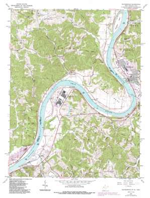
Ravenswood Topo Map Ohio
To zoom in, hover over the map of Ravenswood
USGS Topo Quad 38081h7 - 1:24,000 scale
| Topo Map Name: | Ravenswood |
| USGS Topo Quad ID: | 38081h7 |
| Print Size: | ca. 21 1/4" wide x 27" high |
| Southeast Coordinates: | 38.875° N latitude / 81.75° W longitude |
| Map Center Coordinates: | 38.9375° N latitude / 81.8125° W longitude |
| U.S. States: | OH, WV |
| Filename: | o38081h7.jpg |
| Download Map JPG Image: | Ravenswood topo map 1:24,000 scale |
| Map Type: | Topographic |
| Topo Series: | 7.5´ |
| Map Scale: | 1:24,000 |
| Source of Map Images: | United States Geological Survey (USGS) |
| Alternate Map Versions: |
Ravenswood WV 1960, updated 1963 Download PDF Buy paper map Ravenswood WV 1960, updated 1972 Download PDF Buy paper map Ravenswood WV 1960, updated 1976 Download PDF Buy paper map Ravenswood WV 1960, updated 1978 Download PDF Buy paper map Ravenswood WV 1960, updated 1987 Download PDF Buy paper map Ravenswood WV 1994, updated 1998 Download PDF Buy paper map Ravenswood WV 2011 Download PDF Buy paper map Ravenswood WV 2014 Download PDF Buy paper map Ravenswood WV 2016 Download PDF Buy paper map |
1:24,000 Topo Quads surrounding Ravenswood
> Back to 38081e1 at 1:100,000 scale
> Back to 38080a1 at 1:250,000 scale
> Back to U.S. Topo Maps home
Ravenswood topo map: Gazetteer
Ravenswood: Airports
Jackson County Airport elevation 229m 751′Ravenswood Seaplane Base elevation 172m 564′
Ravenswood: Bars
Sand Creek Bar elevation 172m 564′Ravenswood: Bays
Hughes Eddy elevation 171m 561′Ravenswood: Bends
Great Bend elevation 206m 675′Ravenswood: Crossings
Ravenswood Ferry elevation 172m 564′Ravenswood Ferry elevation 172m 564′
Ravenswood: Dams
Lock and Dam Number 22 (historical) elevation 172m 564′Lock and Dam Number 23 (historical) elevation 169m 554′
Lock Number 22 (historical) elevation 172m 564′
Porter Pond Dam elevation 230m 754′
Turkey Run Lake Dam elevation 181m 593′
Ravenswood: Islands
Buffington Island elevation 177m 580′Towhead Island (historical) elevation 171m 561′
Ravenswood: Lakes
Ritchies Pond elevation 182m 597′Ravenswood: Parks
Keraland Recreation Area elevation 199m 652′Turkey Run Lake Wildlife Management Area elevation 176m 577′
Ravenswood: Populated Places
Apple Grove elevation 182m 597′Estar elevation 182m 597′
Flatwoods elevation 230m 754′
Great Bend elevation 181m 593′
Hills Crossing elevation 184m 603′
Millwood elevation 176m 577′
North Ravenswood elevation 187m 613′
Oldtown Flats elevation 220m 721′
Pleasant View elevation 178m 583′
Ravenswood elevation 185m 606′
Ripley Landing elevation 177m 580′
Rolandus elevation 176m 577′
Saxon elevation 183m 600′
School House (historical) elevation 177m 580′
Sherman elevation 183m 600′
Spiller elevation 214m 702′
Ulric elevation 246m 807′
Willow Grove (historical) elevation 179m 587′
Ravenswood: Post Offices
Applegrove Post Office (historical) elevation 179m 587′Greatbend Post Office (historical) elevation 184m 603′
Ravenswood Post Office elevation 177m 580′
Rolandus Post Office (historical) elevation 176m 577′
Saxon Post Office (historical) elevation 183m 600′
Sherman Post Office elevation 184m 603′
Spiller Post Office (historical) elevation 213m 698′
Ulric Post Office (historical) elevation 245m 803′
Ravenswood: Reservoirs
Kera Lakes elevation 195m 639′Porter Pond elevation 230m 754′
Turkey Foot Lake elevation 189m 620′
Turkey Run Lake elevation 181m 593′
Ravenswood: Ridges
Lathem Ridge elevation 230m 754′Pleasant View Ridge elevation 243m 797′
Ravenswood: Streams
Bar Run elevation 172m 564′Cedar Run elevation 171m 561′
Cooks Run elevation 170m 557′
Dry Run elevation 172m 564′
Granny Run elevation 176m 577′
Groundhog Creek elevation 172m 564′
Lick Run elevation 169m 554′
Little Mill Creek elevation 171m 561′
Little Sandy Creek elevation 172m 564′
Mikes Run elevation 172m 564′
Mill Creek elevation 169m 554′
Mill Run elevation 171m 561′
Oldtown Creek elevation 172m 564′
Pole Run elevation 174m 570′
Sandy Creek elevation 172m 564′
Savers Run elevation 172m 564′
Silver Creek elevation 175m 574′
Skidmore Run elevation 178m 583′
Spring Creek elevation 170m 557′
Stedman Run elevation 177m 580′
Tanner Run elevation 172m 564′
Toms Run elevation 171m 561′
Turkey Run elevation 175m 574′
Ravenswood: Valleys
Copperhead Hollow elevation 173m 567′Lathley Hollow elevation 172m 564′
Ravenswood digital topo map on disk
Buy this Ravenswood topo map showing relief, roads, GPS coordinates and other geographical features, as a high-resolution digital map file on DVD:
Western Virginia & Southern West Virginia
Buy digital topo maps: Western Virginia & Southern West Virginia


