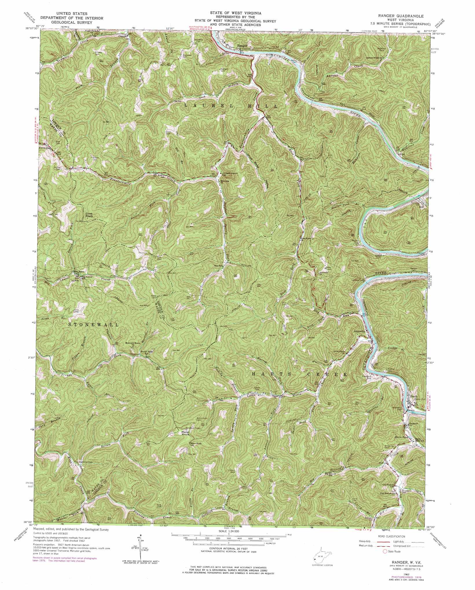
Ranger Topo Map West Virginia
To zoom in, hover over the map of Ranger
USGS Topo Quad 38082a2 - 1:24,000 scale
| Topo Map Name: | Ranger |
| USGS Topo Quad ID: | 38082a2 |
| Print Size: | ca. 21 1/4" wide x 27" high |
| Southeast Coordinates: | 38° N latitude / 82.125° W longitude |
| Map Center Coordinates: | 38.0625° N latitude / 82.1875° W longitude |
| U.S. State: | WV |
| Filename: | o38082a2.jpg |
| Download Map JPG Image: | Ranger topo map 1:24,000 scale |
| Map Type: | Topographic |
| Topo Series: | 7.5´ |
| Map Scale: | 1:24,000 |
| Source of Map Images: | United States Geological Survey (USGS) |
| Alternate Map Versions: |
Ranger WV 1962, updated 1964 Download PDF Buy paper map Ranger WV 1962, updated 1977 Download PDF Buy paper map Ranger WV 2011 Download PDF Buy paper map Ranger WV 2014 Download PDF Buy paper map Ranger WV 2016 Download PDF Buy paper map |
1:24,000 Topo Quads surrounding Ranger
Lavalette |
Winslow |
West Hamlin |
Hamlin |
Garretts Bend |
Wayne |
Nestlow |
Branchland |
Hager |
Griffithsville |
Radnor |
Kiahsville |
Ranger |
Big Creek |
Mud |
Webb |
Wilsondale |
Trace |
Chapmanville |
Henlawson |
Kermit |
Naugatuck |
Myrtle |
Holden |
Logan |
> Back to 38082a1 at 1:100,000 scale
> Back to 38082a1 at 1:250,000 scale
> Back to U.S. Topo Maps home
Ranger topo map: Gazetteer
Ranger: Dams
Bells Fishing Lake Dam elevation 273m 895′Ranger: Lakes
Harts Pond elevation 188m 616′Ranger: Populated Places
Atenville elevation 188m 616′Bolin (historical) elevation 187m 613′
Cuzzie elevation 212m 695′
Eden Park (historical) elevation 192m 629′
Fourteen (historical) elevation 224m 734′
Harts elevation 192m 629′
Lattin (historical) elevation 187m 613′
Ranger elevation 187m 613′
Wewanta elevation 197m 646′
Ranger: Post Offices
Harts Post Office elevation 192m 629′Ranger Post Office elevation 220m 721′
Ranger: Streams
Aarons Creek elevation 178m 583′Bearwallow Branch elevation 220m 721′
Beaver Pond Branch elevation 177m 580′
Bee Branch elevation 204m 669′
Big Branch elevation 180m 590′
Big Branch elevation 183m 600′
Big Harts Creek elevation 181m 593′
Big Ugly Creek elevation 177m 580′
Bridge Branch elevation 185m 606′
Browns Branch elevation 180m 590′
Bryant Fork elevation 276m 905′
Caney Branch elevation 187m 613′
Coal Branch elevation 186m 610′
Curry Branch elevation 186m 610′
Dalton Fork elevation 251m 823′
Dry Run elevation 179m 587′
East Fork Fourteenmile Creek elevation 179m 587′
Fourteenmile Creek elevation 178m 583′
Frances Creek elevation 236m 774′
Gartin Fork elevation 218m 715′
Hamilton Creek elevation 178m 583′
Hampton Creek elevation 176m 577′
Harless Branch elevation 253m 830′
Harvey Fork elevation 203m 666′
Laurel Fork elevation 210m 688′
Lick Branch elevation 175m 574′
Lick Fork elevation 200m 656′
Little Harts Creek elevation 180m 590′
Mudlick Branch elevation 216m 708′
Nelson Fork elevation 215m 705′
Pigpen Branch elevation 230m 754′
Plum Branch elevation 207m 679′
Pretty Branch elevation 266m 872′
Rollem Fork elevation 236m 774′
Sandlick Branch elevation 266m 872′
Short Bend Fork elevation 199m 652′
Steer Fork elevation 207m 679′
Sulphur Spring Fork elevation 196m 643′
Tomblin Branch elevation 244m 800′
Vance Branch elevation 237m 777′
West Fork Big Harts Creek elevation 181m 593′
Witcher Fork elevation 237m 777′
Ranger: Summits
Cove Knob elevation 410m 1345′Mann Knob elevation 429m 1407′
Ranger: Valleys
Short Bend Hollow elevation 188m 616′Ranger digital topo map on disk
Buy this Ranger topo map showing relief, roads, GPS coordinates and other geographical features, as a high-resolution digital map file on DVD:
Western Virginia & Southern West Virginia
Buy digital topo maps: Western Virginia & Southern West Virginia