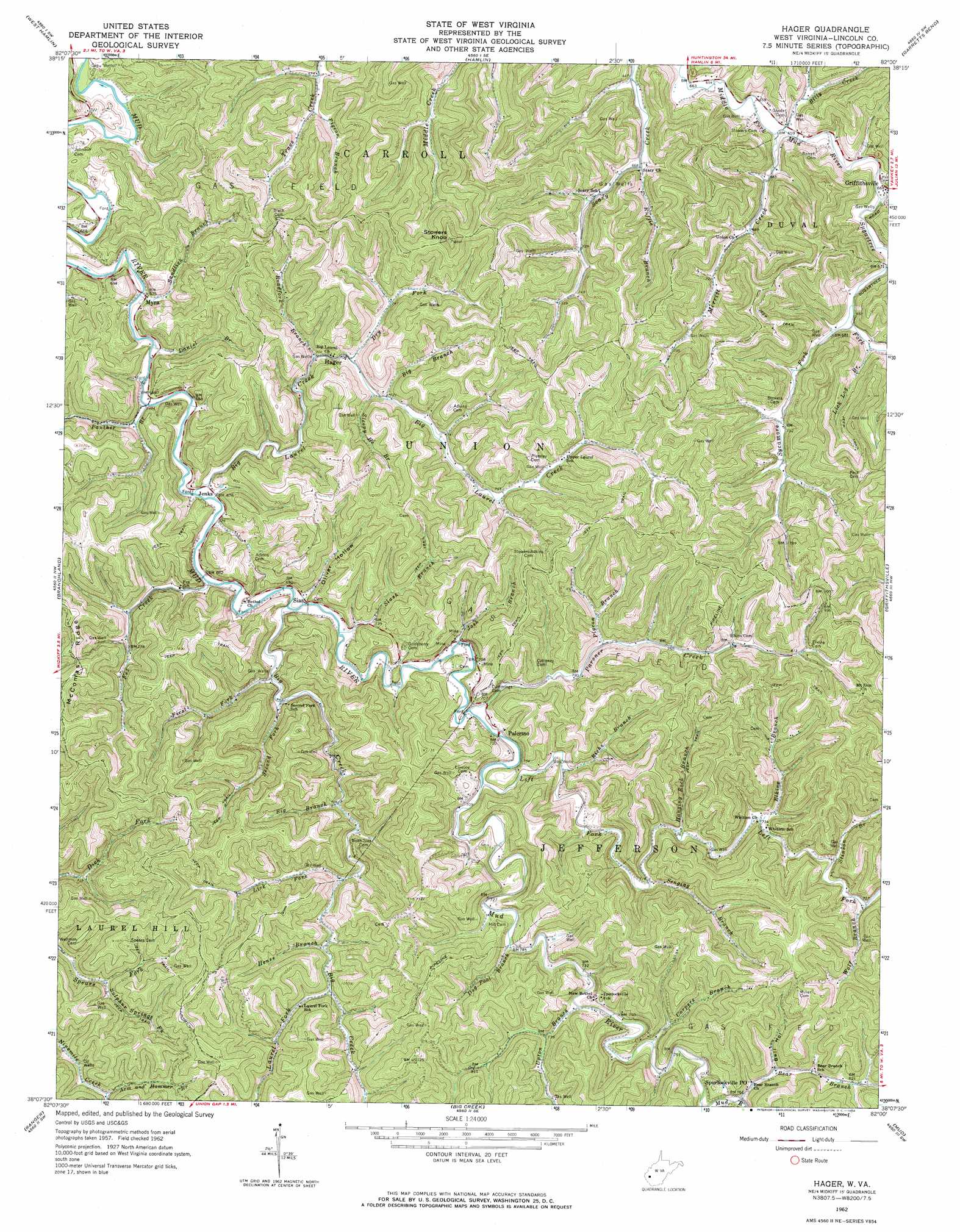
Hager Topo Map West Virginia
To zoom in, hover over the map of Hager
USGS Topo Quad 38082b1 - 1:24,000 scale
| Topo Map Name: | Hager |
| USGS Topo Quad ID: | 38082b1 |
| Print Size: | ca. 21 1/4" wide x 27" high |
| Southeast Coordinates: | 38.125° N latitude / 82° W longitude |
| Map Center Coordinates: | 38.1875° N latitude / 82.0625° W longitude |
| U.S. State: | WV |
| Filename: | o38082b1.jpg |
| Download Map JPG Image: | Hager topo map 1:24,000 scale |
| Map Type: | Topographic |
| Topo Series: | 7.5´ |
| Map Scale: | 1:24,000 |
| Source of Map Images: | United States Geological Survey (USGS) |
| Alternate Map Versions: |
Hager WV 1962, updated 1964 Download PDF Buy paper map Hager WV 2011 Download PDF Buy paper map Hager WV 2014 Download PDF Buy paper map Hager WV 2016 Download PDF Buy paper map |
1:24,000 Topo Quads surrounding Hager
Barboursville |
Milton |
Hurricane |
Scott Depot |
Saint Albans |
Winslow |
West Hamlin |
Hamlin |
Garretts Bend |
Alum Creek |
Nestlow |
Branchland |
Hager |
Griffithsville |
Julian |
Kiahsville |
Ranger |
Big Creek |
Mud |
Madison |
Wilsondale |
Trace |
Chapmanville |
Henlawson |
Clothier |
> Back to 38082a1 at 1:100,000 scale
> Back to 38082a1 at 1:250,000 scale
> Back to U.S. Topo Maps home
Hager topo map: Gazetteer
Hager: Populated Places
Bernie (historical) elevation 254m 833′Hager elevation 212m 695′
Jenks elevation 206m 675′
Myra elevation 202m 662′
Palermo elevation 211m 692′
Sias elevation 207m 679′
Spurlockville elevation 232m 761′
Hager: Post Offices
Myra Post Office elevation 205m 672′Sias Post Office elevation 222m 728′
Spurlockville Post Office (historical) elevation 233m 764′
Hager: Streams
Arm and Hammer Branch elevation 237m 777′Bear Branch elevation 229m 751′
Big Branch elevation 217m 711′
Big Branch elevation 233m 764′
Big Branch elevation 204m 669′
Big Creek elevation 206m 675′
Big Laurel Creek elevation 203m 666′
Billy Creek elevation 200m 656′
Carpers Branch elevation 224m 734′
Daniel Branch elevation 203m 666′
Dog Pool Branch elevation 220m 721′
Dry Fork elevation 224m 734′
Elkins Branch elevation 229m 751′
Fez Creek elevation 207m 679′
First Fork elevation 208m 682′
Hanging Rock Branch elevation 224m 734′
Hense Branch elevation 226m 741′
Josh Branch elevation 209m 685′
Laurel Fork elevation 230m 754′
Left Fork Mud River elevation 219m 718′
Lick Fork elevation 223m 731′
Lick Log Branch elevation 207m 679′
Merritt Creek elevation 200m 656′
Panther Branch elevation 205m 672′
Parsner Creek elevation 211m 692′
Pigeon Branch elevation 212m 695′
Pigeon Branch elevation 220m 721′
Richs Branch elevation 219m 718′
Roadfork Branch elevation 212m 695′
Ruffie Branch elevation 203m 666′
Sandlick Branch elevation 200m 656′
Second Fork elevation 209m 685′
Senging Branch elevation 222m 728′
Slash Branch elevation 205m 672′
Sleepy He Branch elevation 224m 734′
Stinson Branch elevation 228m 748′
Straight Fork elevation 199m 652′
Sugartree Fork elevation 199m 652′
Sulphur Springs Fork elevation 226m 741′
Sycamore Fork elevation 205m 672′
Upton Branch elevation 221m 725′
Wolf Branch elevation 229m 751′
Hager: Summits
Stowers Knob elevation 379m 1243′Hager: Valleys
Bell Hollow elevation 236m 774′Oliver Hollow elevation 209m 685′
Hager digital topo map on disk
Buy this Hager topo map showing relief, roads, GPS coordinates and other geographical features, as a high-resolution digital map file on DVD:
Western Virginia & Southern West Virginia
Buy digital topo maps: Western Virginia & Southern West Virginia