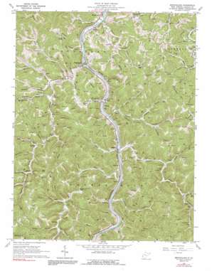
Branchland Topo Map West Virginia
To zoom in, hover over the map of Branchland
USGS Topo Quad 38082b2 - 1:24,000 scale
| Topo Map Name: | Branchland |
| USGS Topo Quad ID: | 38082b2 |
| Print Size: | ca. 21 1/4" wide x 27" high |
| Southeast Coordinates: | 38.125° N latitude / 82.125° W longitude |
| Map Center Coordinates: | 38.1875° N latitude / 82.1875° W longitude |
| U.S. State: | WV |
| Filename: | o38082b2.jpg |
| Download Map JPG Image: | Branchland topo map 1:24,000 scale |
| Map Type: | Topographic |
| Topo Series: | 7.5´ |
| Map Scale: | 1:24,000 |
| Source of Map Images: | United States Geological Survey (USGS) |
| Alternate Map Versions: |
Branchland WV 1962, updated 1964 Download PDF Buy paper map Branchland WV 1962, updated 1964 Download PDF Buy paper map Branchland WV 1962, updated 1991 Download PDF Buy paper map Branchland WV 2011 Download PDF Buy paper map Branchland WV 2014 Download PDF Buy paper map Branchland WV 2016 Download PDF Buy paper map |
1:24,000 Topo Quads surrounding Branchland
> Back to 38082a1 at 1:100,000 scale
> Back to 38082a1 at 1:250,000 scale
> Back to U.S. Topo Maps home
Branchland topo map: Gazetteer
Branchland: Populated Places
Bradyville elevation 183m 600′Branchland elevation 182m 597′
Hubball elevation 193m 633′
Kinder (historical) elevation 196m 643′
Midkiff elevation 182m 597′
Minerva elevation 205m 672′
Pleasant View elevation 180m 590′
Price elevation 213m 698′
Redwing elevation 194m 636′
Rockville elevation 184m 603′
Sheridan elevation 181m 593′
Branchland: Ridges
McComas Ridge elevation 332m 1089′Branchland: Streams
Bee Branch elevation 184m 603′Bluelick Branch elevation 190m 623′
Buck Branch elevation 181m 593′
Camp Branch elevation 171m 561′
Chaney Fork elevation 212m 695′
Cooper Branch elevation 197m 646′
Dick Fork elevation 203m 666′
Falls Branch elevation 204m 669′
Fourmile Creek elevation 171m 561′
Furnett Creek elevation 174m 570′
Hager Fork elevation 189m 620′
Harless Fork elevation 175m 574′
Hollybush Branch elevation 176m 577′
Horse Fork elevation 205m 672′
Horseshoe Branch elevation 203m 666′
Kentuck Fork elevation 177m 580′
Laurel Branch elevation 173m 567′
Laurel Fork elevation 201m 659′
Lick Branch elevation 190m 623′
Little Laurel Creek elevation 202m 662′
Lower Twin Branch elevation 191m 626′
Lowgap Branch elevation 173m 567′
McClarity Branch elevation 213m 698′
McComas Branch elevation 172m 564′
Mill Branch elevation 176m 577′
Ninemile Creek elevation 172m 564′
Peyton Branch elevation 174m 570′
Pound Fork elevation 186m 610′
Ranger Branch elevation 173m 567′
Red River Fork elevation 193m 633′
Reuben Branch elevation 169m 554′
Rockhouse Branch elevation 192m 629′
Sixmile Creek elevation 171m 561′
Spears Fork elevation 209m 685′
Stout Creek elevation 175m 574′
Tenmile Creek elevation 172m 564′
Thomas Branch elevation 200m 656′
Trace Fork elevation 173m 567′
Twomile Creek elevation 169m 554′
Upper Twin Branch elevation 192m 629′
Branchland: Summits
Bear Knob elevation 351m 1151′Flag Knob elevation 367m 1204′
Branchland: Valleys
Franklin Hollow elevation 177m 580′Stone Coal Hollow elevation 175m 574′
Branchland digital topo map on disk
Buy this Branchland topo map showing relief, roads, GPS coordinates and other geographical features, as a high-resolution digital map file on DVD:
Western Virginia & Southern West Virginia
Buy digital topo maps: Western Virginia & Southern West Virginia


