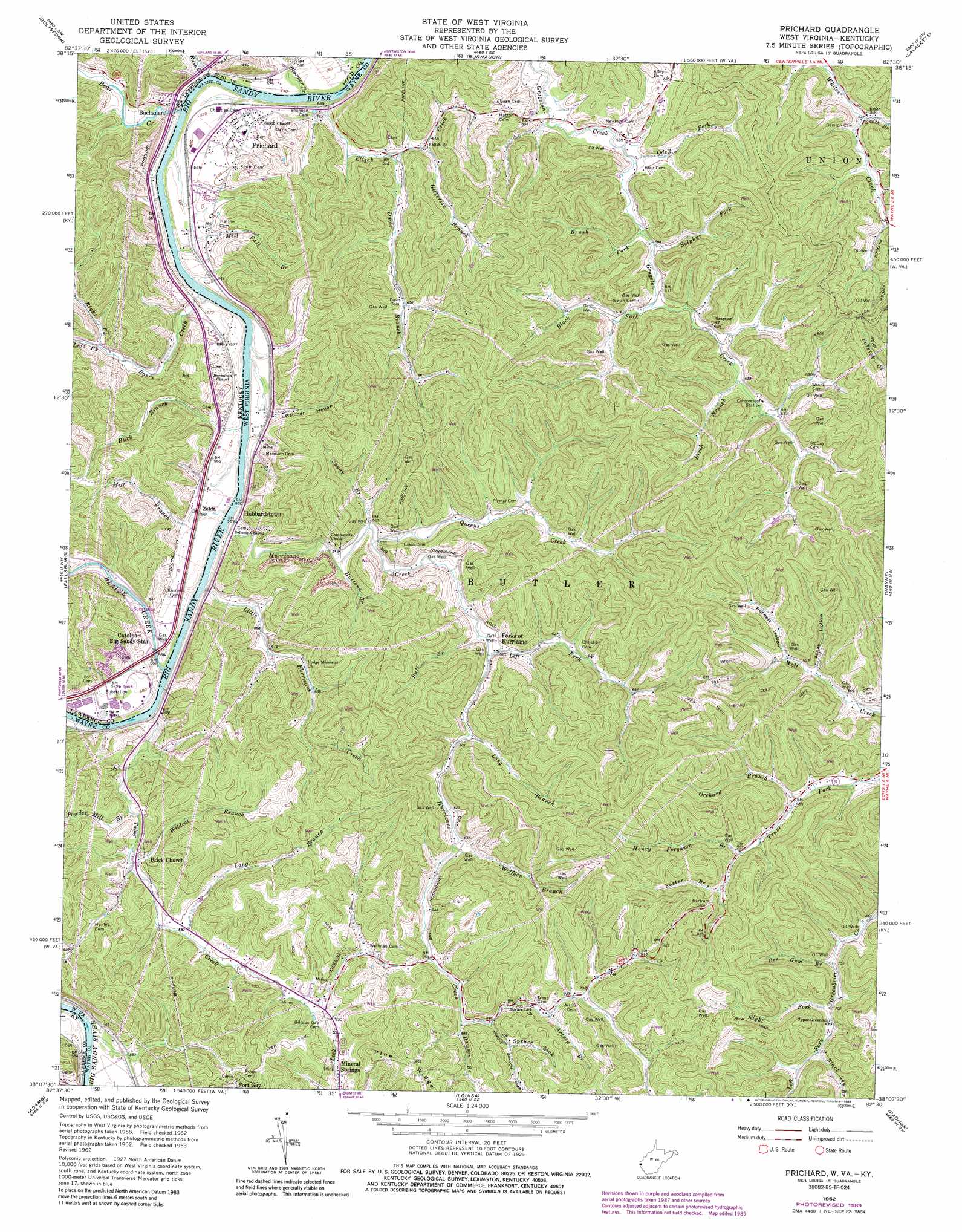
Prichard Topo Map West Virginia
To zoom in, hover over the map of Prichard
USGS Topo Quad 38082b5 - 1:24,000 scale
| Topo Map Name: | Prichard |
| USGS Topo Quad ID: | 38082b5 |
| Print Size: | ca. 21 1/4" wide x 27" high |
| Southeast Coordinates: | 38.125° N latitude / 82.5° W longitude |
| Map Center Coordinates: | 38.1875° N latitude / 82.5625° W longitude |
| U.S. States: | WV, KY |
| Filename: | o38082b5.jpg |
| Download Map JPG Image: | Prichard topo map 1:24,000 scale |
| Map Type: | Topographic |
| Topo Series: | 7.5´ |
| Map Scale: | 1:24,000 |
| Source of Map Images: | United States Geological Survey (USGS) |
| Alternate Map Versions: |
Prichard WV 1953, updated 1954 Download PDF Buy paper map Prichard WV 1953, updated 1957 Download PDF Buy paper map Prichard WV 1962, updated 1963 Download PDF Buy paper map Prichard WV 1962, updated 1972 Download PDF Buy paper map Prichard WV 1962, updated 1976 Download PDF Buy paper map Prichard WV 1962, updated 1977 Download PDF Buy paper map Prichard WV 1962, updated 1989 Download PDF Buy paper map Prichard WV 2011 Download PDF Buy paper map Prichard WV 2014 Download PDF Buy paper map Prichard WV 2016 Download PDF Buy paper map |
1:24,000 Topo Quads surrounding Prichard
Argillite |
Ashland |
Catlettsburg |
Huntington |
Barboursville |
Rush |
Boltsfork |
Burnaugh |
Lavalette |
Winslow |
Webbville |
Fallsburg |
Prichard |
Wayne |
Nestlow |
Blaine |
Adams |
Louisa |
Radnor |
Kiahsville |
Sitka |
Richardson |
Milo |
Webb |
Wilsondale |
> Back to 38082a1 at 1:100,000 scale
> Back to 38082a1 at 1:250,000 scale
> Back to U.S. Topo Maps home
Prichard topo map: Gazetteer
Prichard: Airports
Big 'G' Heliport elevation 227m 744′Prichard: Bridges
Bear Creek Bridge elevation 162m 531′Prichard: Populated Places
Buchanan elevation 173m 567′Greenwood (historical) elevation 174m 570′
Hubbardstown elevation 180m 590′
Mouth of Bear (historical) elevation 162m 531′
Prichard elevation 179m 587′
Rockville (historical) elevation 168m 551′
Zelda elevation 171m 561′
Prichard: Post Offices
Canterbury Post Office (historical) elevation 162m 531′Catalpa Post Office (historical) elevation 172m 564′
Durney Post Office (historical) elevation 171m 561′
Mouth of Blaine Post Office (historical) elevation 159m 521′
Prichard: Streams
Artrip Branch elevation 220m 721′Bear Creek elevation 162m 531′
Bee Gum Branch elevation 207m 679′
Birch Branch elevation 185m 606′
Black Fork elevation 182m 597′
Black Log Branch elevation 220m 721′
Blaine Creek elevation 160m 524′
Bloomer Branch elevation 164m 538′
Brush Fork elevation 176m 577′
Bull Branch elevation 171m 561′
Burk Branch elevation 164m 538′
Davis Branch elevation 165m 541′
Dawson Branch elevation 204m 669′
Elijah Creek elevation 164m 538′
Foster Branch elevation 224m 734′
Gilkerson Branch elevation 169m 554′
Hattons Branch elevation 165m 541′
Henry Ferguson Branch elevation 212m 695′
Hurricane Creek elevation 249m 816′
Left Fork Greenbrier Creek elevation 214m 702′
Left Fork Hurricane Creek elevation 175m 574′
Left Fork Roe Creek elevation 178m 583′
Little Hurricane Creek elevation 169m 554′
Long Branch elevation 176m 577′
Long Branch elevation 181m 593′
Mill Branch elevation 164m 538′
Mill Fall Branch elevation 164m 538′
Odell Fork elevation 173m 567′
Orchard Branch elevation 200m 656′
Powder Mill Branch elevation 173m 567′
Queens Creek elevation 165m 541′
Right Fork Greenbrier Creek elevation 211m 692′
Right Fork Roe Creek elevation 178m 583′
Roe Creek elevation 165m 541′
Rush Creek elevation 164m 538′
Smith Branch elevation 192m 629′
Spruce Lick elevation 209m 685′
Sugar Branch elevation 165m 541′
Sulphur Fork elevation 177m 580′
Tabor Creek elevation 165m 541′
Wildcat Branch elevation 168m 551′
Wolfpen Branch elevation 187m 613′
Prichard: Valleys
Belcher Hollow elevation 171m 561′Jonas Hollow elevation 205m 672′
Puckett Hollow elevation 211m 692′
Prichard digital topo map on disk
Buy this Prichard topo map showing relief, roads, GPS coordinates and other geographical features, as a high-resolution digital map file on DVD:
Western Virginia & Southern West Virginia
Buy digital topo maps: Western Virginia & Southern West Virginia