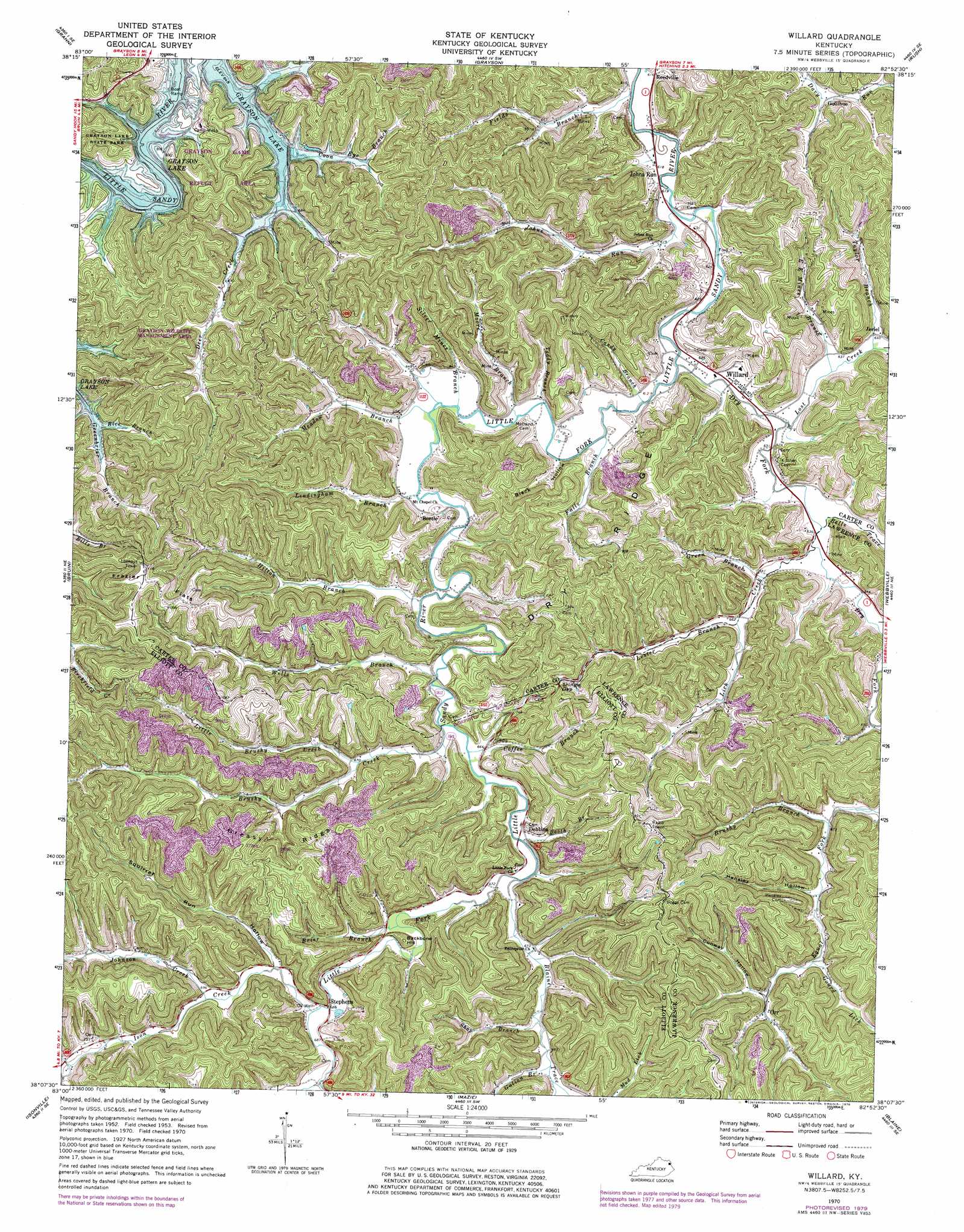
Willard Topo Map Kentucky
To zoom in, hover over the map of Willard
USGS Topo Quad 38082b8 - 1:24,000 scale
| Topo Map Name: | Willard |
| USGS Topo Quad ID: | 38082b8 |
| Print Size: | ca. 21 1/4" wide x 27" high |
| Southeast Coordinates: | 38.125° N latitude / 82.875° W longitude |
| Map Center Coordinates: | 38.1875° N latitude / 82.9375° W longitude |
| U.S. State: | KY |
| Filename: | o38082b8.jpg |
| Download Map JPG Image: | Willard topo map 1:24,000 scale |
| Map Type: | Topographic |
| Topo Series: | 7.5´ |
| Map Scale: | 1:24,000 |
| Source of Map Images: | United States Geological Survey (USGS) |
| Alternate Map Versions: |
Willard KY 1953, updated 1955 Download PDF Buy paper map Willard KY 1953, updated 1967 Download PDF Buy paper map Willard KY 1970, updated 1972 Download PDF Buy paper map Willard KY 1970, updated 1979 Download PDF Buy paper map Willard KY 2010 Download PDF Buy paper map Willard KY 2013 Download PDF Buy paper map Willard KY 2016 Download PDF Buy paper map |
1:24,000 Topo Quads surrounding Willard
Wesleyville |
Tygarts Valley |
Oldtown |
Argillite |
Ashland |
Olive Hill |
Grahn |
Grayson |
Rush |
Boltsfork |
Ault |
Bruin |
Willard |
Webbville |
Fallsburg |
Sandy Hook |
Isonville |
Mazie |
Blaine |
Adams |
Lenox |
Dingus |
Redbush |
Sitka |
Richardson |
> Back to 38082a1 at 1:100,000 scale
> Back to 38082a1 at 1:250,000 scale
> Back to U.S. Topo Maps home
Willard topo map: Gazetteer
Willard: Flats
Frazier Flats elevation 331m 1085′Willard: Gaps
Shingle Gap elevation 271m 889′Willard: Parks
Grayson Game Refuge Area elevation 252m 826′Willard: Populated Places
Antioch elevation 204m 669′Beetle elevation 198m 649′
Davy Run elevation 200m 656′
Dobbins elevation 206m 675′
Gollihue elevation 201m 659′
Gomez elevation 222m 728′
Jeriel elevation 196m 643′
Johns Run elevation 187m 613′
Lick Creek elevation 207m 679′
Orr elevation 217m 711′
Stephens elevation 208m 682′
Willard elevation 192m 629′
Willard: Post Offices
Beetle Post Office (historical) elevation 204m 669′Deer Creek Post Office (historical) elevation 256m 839′
Dobbins Post Office (historical) elevation 206m 675′
Dry Fork Post Office (historical) elevation 190m 623′
Gollihue Post Office (historical) elevation 200m 656′
Jeriel Post Office (historical) elevation 197m 646′
Johns Run Post Office (historical) elevation 189m 620′
Lego Post Office (historical) elevation 203m 666′
Little John Post Office (historical) elevation 200m 656′
McDavid Post Office (historical) elevation 205m 672′
Mountain Chapel United Baptist Church elevation 194m 636′
Orr Post Office (historical) elevation 312m 1023′
Partlow Post Office (historical) elevation 198m 649′
Reedville Post Office (historical) elevation 189m 620′
Rosedale Post Office (historical) elevation 205m 672′
Sansilk Post Office (historical) elevation 203m 666′
Stephens Post Office (historical) elevation 209m 685′
Willard: Ridges
Dry Ridge elevation 287m 941′Greasy Ridge elevation 233m 764′
Willard: Streams
Bells Trace Creek elevation 189m 620′Blaine Trace elevation 201m 659′
Booth Branch elevation 201m 659′
Brier Branch elevation 203m 666′
Brushy Branch elevation 204m 669′
Brushy Creek elevation 203m 666′
Candy Branch elevation 189m 620′
Coffee Branch elevation 197m 646′
Coon Eye Branch elevation 208m 682′
Deer Creek elevation 196m 643′
Dry Fork elevation 189m 620′
E K Mines Branch elevation 192m 629′
Falls Branch elevation 189m 620′
Fields Branch elevation 188m 616′
Galion Branch elevation 209m 685′
Gourd Lick elevation 209m 685′
Green Branch elevation 193m 633′
Hamilton Creek elevation 206m 675′
Hilton Branch elevation 196m 643′
Ison Creek elevation 203m 666′
Johns Run elevation 185m 606′
Johnson Creek elevation 213m 698′
Leadingham Branch elevation 191m 626′
Lester Branch elevation 198m 649′
Lick Creek elevation 193m 633′
Little Brushy Creek elevation 206m 675′
Lost Creek elevation 189m 620′
McDavid Branch elevation 191m 626′
Meadow Branch elevation 191m 626′
Moore Branch elevation 191m 626′
Rice Branch elevation 199m 652′
Rockhouse Fork elevation 209m 685′
Shop Branch elevation 206m 675′
Silver Mines Branch elevation 191m 626′
Taylor Branch elevation 191m 626′
Teddy Branch elevation 193m 633′
Wells Branch elevation 200m 656′
Willard: Summits
Backbone Hill elevation 242m 793′Willard: Valleys
Black Hollow elevation 201m 659′Conway Hollow elevation 218m 715′
Hensley Hollow elevation 205m 672′
Squirrel Run Hollow elevation 208m 682′
Willard digital topo map on disk
Buy this Willard topo map showing relief, roads, GPS coordinates and other geographical features, as a high-resolution digital map file on DVD:
Western Virginia & Southern West Virginia
Buy digital topo maps: Western Virginia & Southern West Virginia