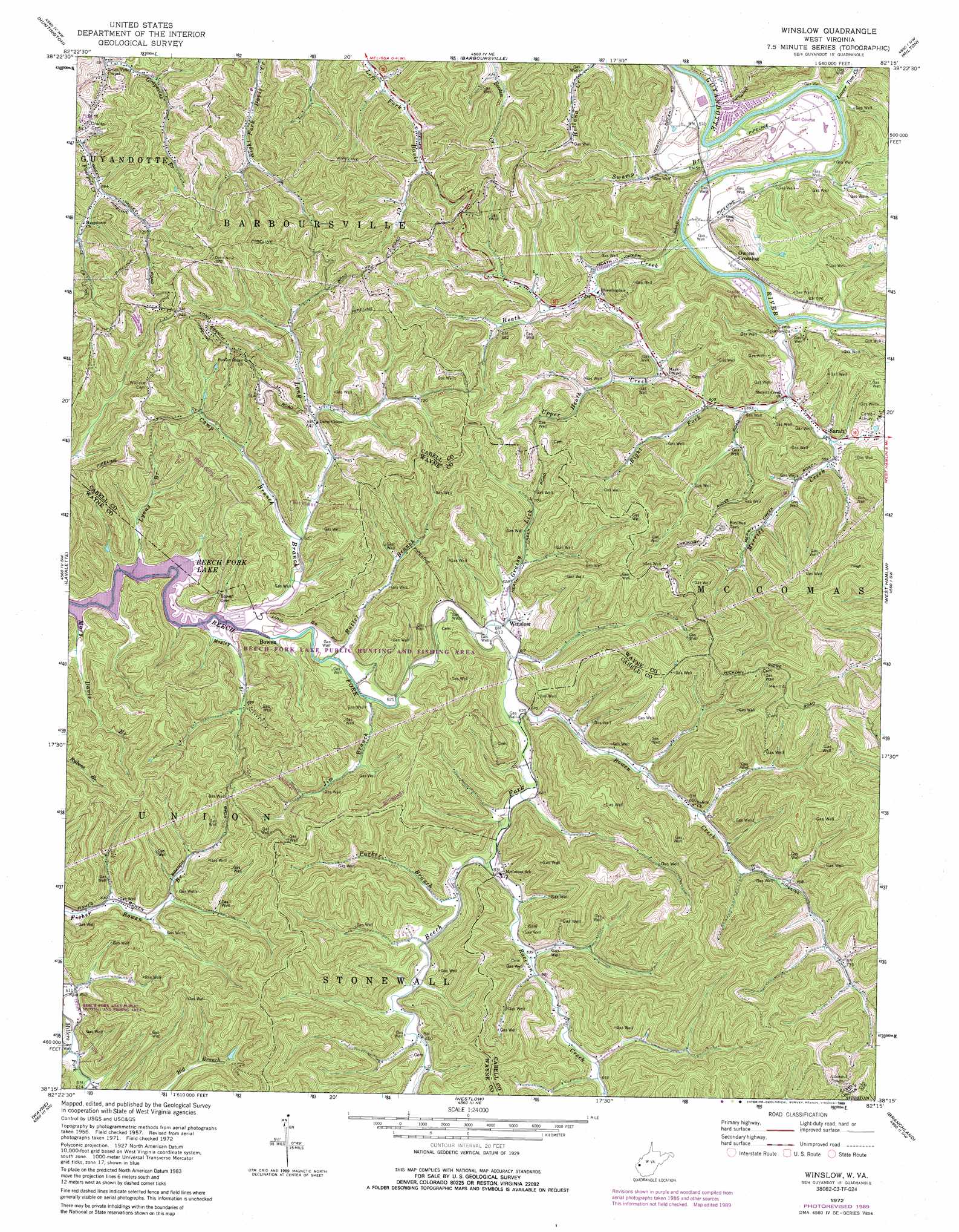
Winslow Topo Map West Virginia
To zoom in, hover over the map of Winslow
USGS Topo Quad 38082c3 - 1:24,000 scale
| Topo Map Name: | Winslow |
| USGS Topo Quad ID: | 38082c3 |
| Print Size: | ca. 21 1/4" wide x 27" high |
| Southeast Coordinates: | 38.25° N latitude / 82.25° W longitude |
| Map Center Coordinates: | 38.3125° N latitude / 82.3125° W longitude |
| U.S. State: | WV |
| Filename: | o38082c3.jpg |
| Download Map JPG Image: | Winslow topo map 1:24,000 scale |
| Map Type: | Topographic |
| Topo Series: | 7.5´ |
| Map Scale: | 1:24,000 |
| Source of Map Images: | United States Geological Survey (USGS) |
| Alternate Map Versions: |
Winslow WV 1957, updated 1959 Download PDF Buy paper map Winslow WV 1957, updated 1965 Download PDF Buy paper map Winslow WV 1972, updated 1973 Download PDF Buy paper map Winslow WV 1972, updated 1977 Download PDF Buy paper map Winslow WV 1972, updated 1987 Download PDF Buy paper map Winslow WV 1972, updated 1989 Download PDF Buy paper map Winslow WV 2011 Download PDF Buy paper map Winslow WV 2014 Download PDF Buy paper map Winslow WV 2016 Download PDF Buy paper map |
1:24,000 Topo Quads surrounding Winslow
Kitts Hill |
Aid |
Athalia |
Glenwood |
Mount Olive |
Catlettsburg |
Huntington |
Barboursville |
Milton |
Hurricane |
Burnaugh |
Lavalette |
Winslow |
West Hamlin |
Hamlin |
Prichard |
Wayne |
Nestlow |
Branchland |
Hager |
Louisa |
Radnor |
Kiahsville |
Ranger |
Big Creek |
> Back to 38082a1 at 1:100,000 scale
> Back to 38082a1 at 1:250,000 scale
> Back to U.S. Topo Maps home
Winslow topo map: Gazetteer
Winslow: Parks
Beech Fork State Park elevation 183m 600′Winslow: Populated Places
Bartram (historical) elevation 195m 639′Bowen elevation 182m 597′
Johnson (historical) elevation 195m 639′
Owens Crossing elevation 178m 583′
Sarah elevation 176m 577′
Winslow elevation 187m 613′
Winslow: Streams
Bowen Creek elevation 185m 606′Butler Branch elevation 182m 597′
Camp Branch elevation 184m 603′
Grassy Lick elevation 183m 600′
Heath Creek elevation 166m 544′
Jim Branch elevation 182m 597′
Lick Branch elevation 192m 629′
Long Branch elevation 177m 580′
Lower Tom Creek elevation 167m 547′
Lyons Branch elevation 177m 580′
Merritt Creek elevation 164m 538′
Moxley Branch elevation 178m 583′
Parker Branch elevation 188m 616′
Raccoon Creek elevation 186m 610′
Right Fork Merritt Creek elevation 171m 561′
Swamp Branch elevation 168m 551′
Upper Heath Creek elevation 173m 567′
Winslow digital topo map on disk
Buy this Winslow topo map showing relief, roads, GPS coordinates and other geographical features, as a high-resolution digital map file on DVD:
Western Virginia & Southern West Virginia
Buy digital topo maps: Western Virginia & Southern West Virginia