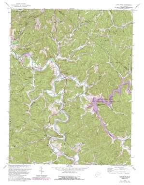
Lavalette Topo Map West Virginia
To zoom in, hover over the map of Lavalette
USGS Topo Quad 38082c4 - 1:24,000 scale
| Topo Map Name: | Lavalette |
| USGS Topo Quad ID: | 38082c4 |
| Print Size: | ca. 21 1/4" wide x 27" high |
| Southeast Coordinates: | 38.25° N latitude / 82.375° W longitude |
| Map Center Coordinates: | 38.3125° N latitude / 82.4375° W longitude |
| U.S. State: | WV |
| Filename: | o38082c4.jpg |
| Download Map JPG Image: | Lavalette topo map 1:24,000 scale |
| Map Type: | Topographic |
| Topo Series: | 7.5´ |
| Map Scale: | 1:24,000 |
| Source of Map Images: | United States Geological Survey (USGS) |
| Alternate Map Versions: |
Lavalette WV 1957, updated 1959 Download PDF Buy paper map Lavalette WV 1957, updated 1966 Download PDF Buy paper map Lavalette WV 1972, updated 1974 Download PDF Buy paper map Lavalette WV 1972, updated 1974 Download PDF Buy paper map Lavalette WV 1972, updated 1989 Download PDF Buy paper map Lavalette WV 2011 Download PDF Buy paper map Lavalette WV 2014 Download PDF Buy paper map Lavalette WV 2016 Download PDF Buy paper map |
1:24,000 Topo Quads surrounding Lavalette
> Back to 38082a1 at 1:100,000 scale
> Back to 38082a1 at 1:250,000 scale
> Back to U.S. Topo Maps home
Lavalette topo map: Gazetteer
Lavalette: Dams
Beech Fork Lake Dam elevation 169m 554′Lavalette: Parks
Beech Fork Lake Wildlife Management Area elevation 194m 636′Lavalette: Populated Places
Ardel elevation 180m 590′Booton elevation 184m 603′
Dickson elevation 174m 570′
Hodges elevation 213m 698′
Lavalette elevation 175m 574′
Shoals elevation 173m 567′
Lavalette: Post Offices
Shoals Post Office elevation 176m 577′Lavalette: Reservoirs
Beech Fork Lake elevation 168m 551′Lavalette: Streams
Beech Fork elevation 162m 531′Big Creek elevation 171m 561′
Camp Creek elevation 162m 531′
Cherry Branch elevation 194m 636′
Childers Branch elevation 177m 580′
Falls Branch elevation 167m 547′
Fisher Bowen Branch elevation 180m 590′
Garrett Creek elevation 176m 577′
Haneys Branch elevation 163m 534′
Long Branch elevation 203m 666′
Lynn Creek elevation 164m 538′
Mary Davis Branch elevation 177m 580′
Mays Branch elevation 168m 551′
Millers Fork elevation 177m 580′
Newcomb Creek elevation 162m 531′
Plymale Branch elevation 163m 534′
Price Creek elevation 177m 580′
Right Fork Camp Creek elevation 165m 541′
Right Fork Garrett Creek elevation 180m 590′
Rubens Branch elevation 177m 580′
Shoal Branch elevation 175m 574′
Spring Branch elevation 172m 564′
Stowers Branch elevation 177m 580′
Lavalette digital topo map on disk
Buy this Lavalette topo map showing relief, roads, GPS coordinates and other geographical features, as a high-resolution digital map file on DVD:
Western Virginia & Southern West Virginia
Buy digital topo maps: Western Virginia & Southern West Virginia


