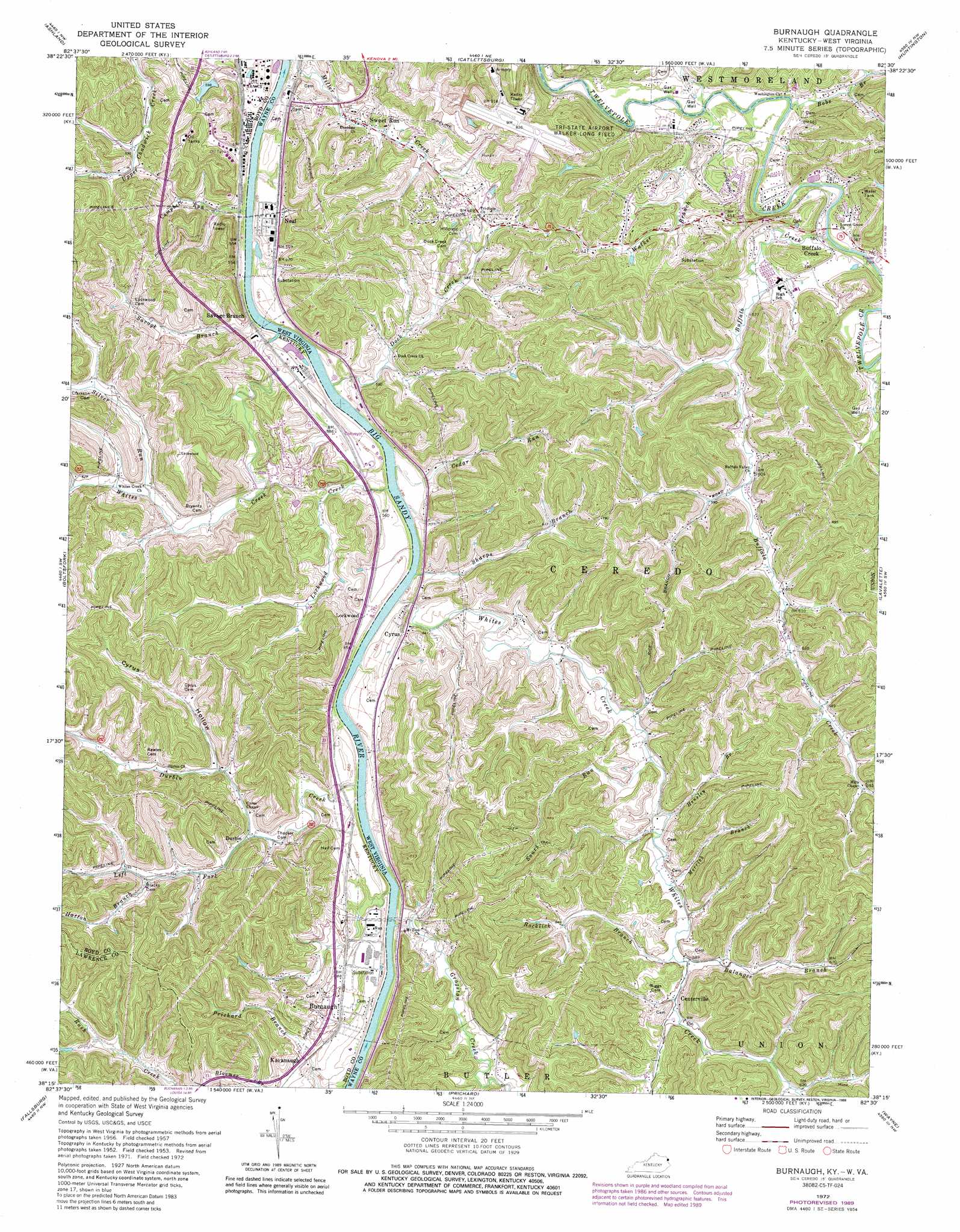
Burnaugh Topo Map West Virginia
To zoom in, hover over the map of Burnaugh
USGS Topo Quad 38082c5 - 1:24,000 scale
| Topo Map Name: | Burnaugh |
| USGS Topo Quad ID: | 38082c5 |
| Print Size: | ca. 21 1/4" wide x 27" high |
| Southeast Coordinates: | 38.25° N latitude / 82.5° W longitude |
| Map Center Coordinates: | 38.3125° N latitude / 82.5625° W longitude |
| U.S. States: | WV, KY |
| Filename: | o38082c5.jpg |
| Download Map JPG Image: | Burnaugh topo map 1:24,000 scale |
| Map Type: | Topographic |
| Topo Series: | 7.5´ |
| Map Scale: | 1:24,000 |
| Source of Map Images: | United States Geological Survey (USGS) |
| Alternate Map Versions: |
Burnaugh KY 1953, updated 1956 Download PDF Buy paper map Burnaugh KY 1957, updated 1959 Download PDF Buy paper map Burnaugh KY 1957, updated 1966 Download PDF Buy paper map Burnaugh KY 1972, updated 1974 Download PDF Buy paper map Burnaugh KY 1972, updated 1978 Download PDF Buy paper map Burnaugh KY 1972, updated 1989 Download PDF Buy paper map Burnaugh KY 2011 Download PDF Buy paper map Burnaugh KY 2013 Download PDF Buy paper map Burnaugh KY 2016 Download PDF Buy paper map |
1:24,000 Topo Quads surrounding Burnaugh
Greenup |
Ironton |
Kitts Hill |
Aid |
Athalia |
Argillite |
Ashland |
Catlettsburg |
Huntington |
Barboursville |
Rush |
Boltsfork |
Burnaugh |
Lavalette |
Winslow |
Webbville |
Fallsburg |
Prichard |
Wayne |
Nestlow |
Blaine |
Adams |
Louisa |
Radnor |
Kiahsville |
> Back to 38082a1 at 1:100,000 scale
> Back to 38082a1 at 1:250,000 scale
> Back to U.S. Topo Maps home
Burnaugh topo map: Gazetteer
Burnaugh: Airports
Tennessee Gas Heliport elevation 173m 567′Tri-State Airport elevation 232m 761′
Burnaugh: Populated Places
Buffalo Creek elevation 167m 547′Burnaugh elevation 179m 587′
Centerville elevation 180m 590′
Cyrus elevation 173m 567′
Durbin elevation 168m 551′
Durbin-Burnaugh elevation 178m 583′
Hidden Valley elevation 190m 623′
Kavanaugh elevation 175m 574′
Lockwood elevation 175m 574′
Meadow Haven elevation 170m 557′
Neal elevation 176m 577′
Savage Branch elevation 169m 554′
Sweet Run elevation 169m 554′
Whites Creek elevation 189m 620′
Burnaugh: Post Offices
Jim Wood Post Office (historical) elevation 171m 561′Potomac Post Office (historical) elevation 185m 606′
Burnaugh: Streams
Balangee Branch elevation 179m 587′Bobs Branch elevation 158m 518′
Buffalo Creek elevation 158m 518′
Campbell Run elevation 161m 528′
Cedar Run elevation 160m 524′
Dock Creek elevation 160m 524′
Dog Fork elevation 181m 593′
Durbin Creek elevation 162m 531′
Ellis Fork elevation 165m 541′
Gragston Creek elevation 163m 534′
Hatton Branch elevation 176m 577′
Hensley Branch elevation 173m 567′
Left Fork Durbin Creek elevation 164m 538′
Lockwood Creek elevation 160m 524′
Merrick Branch elevation 175m 574′
Prichard Branch elevation 163m 534′
Rocklick Branch elevation 178m 583′
Savage Branch elevation 160m 524′
Sharps Branch elevation 165m 541′
Silver Run elevation 170m 557′
Sours Run elevation 171m 561′
Walker Branch elevation 159m 521′
Whites Creek elevation 162m 531′
Whites Creek elevation 160m 524′
Burnaugh: Valleys
Cyrus Hollow elevation 173m 567′Burnaugh digital topo map on disk
Buy this Burnaugh topo map showing relief, roads, GPS coordinates and other geographical features, as a high-resolution digital map file on DVD:
Western Virginia & Southern West Virginia
Buy digital topo maps: Western Virginia & Southern West Virginia