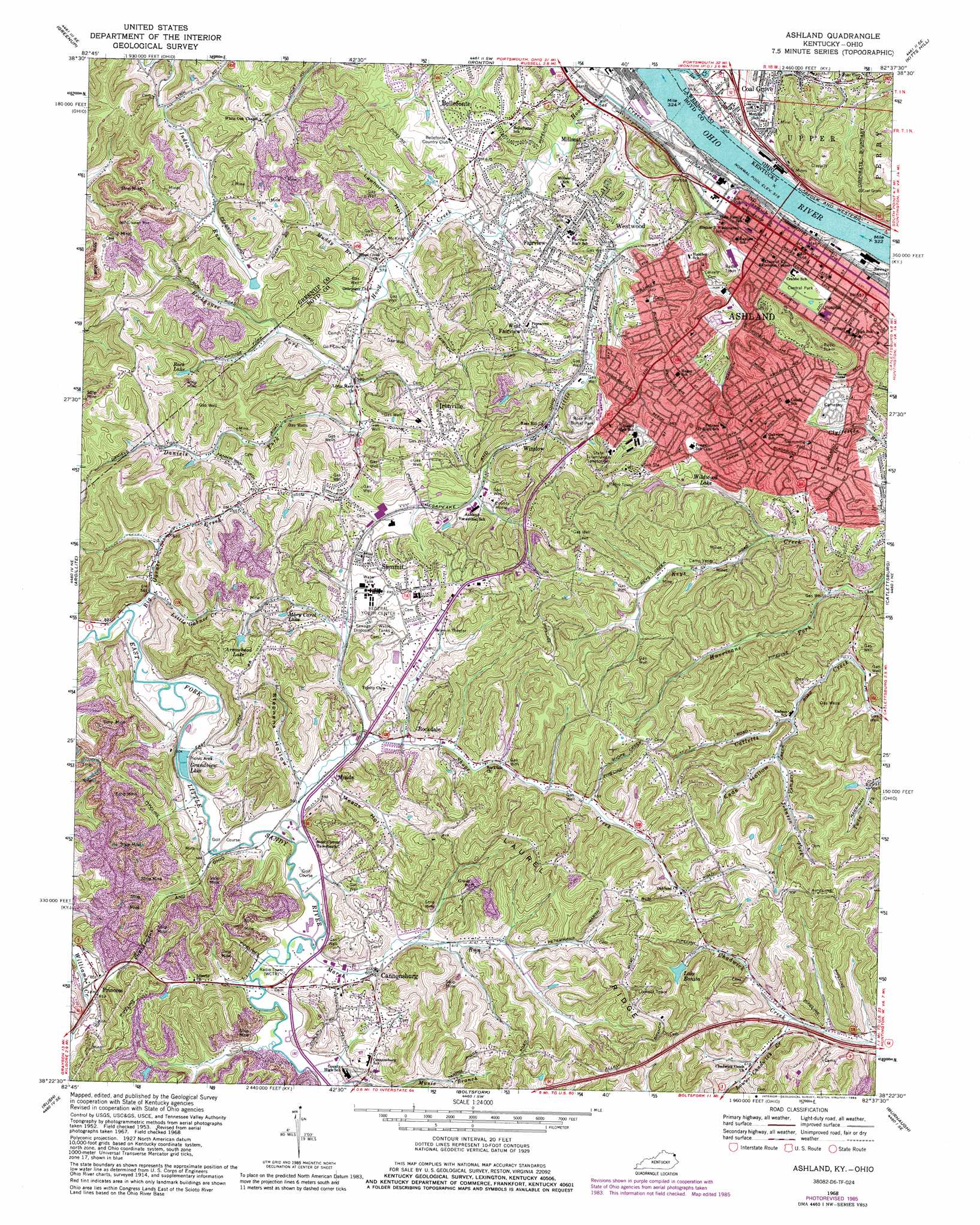
Ashland Topo Map Kentucky
To zoom in, hover over the map of Ashland
USGS Topo Quad 38082d6 - 1:24,000 scale
| Topo Map Name: | Ashland |
| USGS Topo Quad ID: | 38082d6 |
| Print Size: | ca. 21 1/4" wide x 27" high |
| Southeast Coordinates: | 38.375° N latitude / 82.625° W longitude |
| Map Center Coordinates: | 38.4375° N latitude / 82.6875° W longitude |
| U.S. States: | KY, OH |
| Filename: | o38082d6.jpg |
| Download Map JPG Image: | Ashland topo map 1:24,000 scale |
| Map Type: | Topographic |
| Topo Series: | 7.5´ |
| Map Scale: | 1:24,000 |
| Source of Map Images: | United States Geological Survey (USGS) |
| Alternate Map Versions: |
Ashland KY 1953, updated 1955 Download PDF Buy paper map Ashland KY 1958, updated 1959 Download PDF Buy paper map Ashland KY 1968, updated 1970 Download PDF Buy paper map Ashland KY 1968, updated 1976 Download PDF Buy paper map Ashland KY 1968, updated 1985 Download PDF Buy paper map Ashland KY 2010 Download PDF Buy paper map Ashland KY 2013 Download PDF Buy paper map Ashland KY 2016 Download PDF Buy paper map |
1:24,000 Topo Quads surrounding Ashland
Portsmouth |
Wheelersburg |
Pedro |
Sherritts |
Waterloo |
Load |
Greenup |
Ironton |
Kitts Hill |
Aid |
Oldtown |
Argillite |
Ashland |
Catlettsburg |
Huntington |
Grayson |
Rush |
Boltsfork |
Burnaugh |
Lavalette |
Willard |
Webbville |
Fallsburg |
Prichard |
Wayne |
> Back to 38082a1 at 1:100,000 scale
> Back to 38082a1 at 1:250,000 scale
> Back to U.S. Topo Maps home
Ashland topo map: Gazetteer
Ashland: Lakes
Rock Lake elevation 213m 698′Ashland: Parks
Central Park elevation 171m 561′Ashland: Populated Places
Ashland elevation 168m 551′Bellefonte elevation 194m 636′
Cannonsburg elevation 185m 606′
Chadwick Creek elevation 237m 777′
Fairview elevation 195m 639′
Geigers Crossing elevation 174m 570′
Ironville elevation 219m 718′
Little Garner elevation 179m 587′
Meads elevation 185m 606′
Millseat elevation 195m 639′
Princess elevation 185m 606′
Rockdale elevation 200m 656′
Summit elevation 220m 721′
West Fairview elevation 219m 718′
Westwood elevation 208m 682′
Winslow elevation 184m 603′
Ashland: Post Offices
Amanda Post Office elevation 209m 685′East Fork Post Office (historical) elevation 177m 580′
Herd Post Office (historical) elevation 188m 616′
McNeal Post Office (historical) elevation 180m 590′
Mock Post Office (historical) elevation 240m 787′
Princess Post Office (historical) elevation 186m 610′
Winslow Post Office (historical) elevation 215m 705′
Ashland: Reservoirs
Arrowhead Lake elevation 228m 748′Bonita Lake elevation 213m 698′
Grandview Lake elevation 176m 577′
Mary Carol Lake elevation 215m 705′
Wildwood Lake elevation 190m 623′
Ashland: Ridges
Laurel Ridge elevation 218m 715′Ashland: Streams
Big Garner Creek elevation 173m 567′Daniels Fork elevation 181m 593′
Hood Creek elevation 156m 511′
Hurricane Fork elevation 168m 551′
Johnson Fork elevation 181m 593′
Little Garner Creek elevation 175m 574′
Little Hood Creek elevation 165m 541′
Lower Chadwick Creek elevation 180m 590′
Marsh Run elevation 177m 580′
Muddy Branch elevation 171m 561′
Rockhouse Fork elevation 181m 593′
Shope Creek elevation 183m 600′
Ashland: Valleys
Eads Hollow elevation 191m 626′Lawhorn Hollow elevation 175m 574′
Meads Hollow elevation 179m 587′
Stephens Hollow elevation 179m 587′
Ashland digital topo map on disk
Buy this Ashland topo map showing relief, roads, GPS coordinates and other geographical features, as a high-resolution digital map file on DVD:
Western Virginia & Southern West Virginia
Buy digital topo maps: Western Virginia & Southern West Virginia