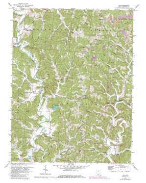
Aid Topo Map Ohio
To zoom in, hover over the map of Aid
USGS Topo Quad 38082e4 - 1:24,000 scale
| Topo Map Name: | Aid |
| USGS Topo Quad ID: | 38082e4 |
| Print Size: | ca. 21 1/4" wide x 27" high |
| Southeast Coordinates: | 38.5° N latitude / 82.375° W longitude |
| Map Center Coordinates: | 38.5625° N latitude / 82.4375° W longitude |
| U.S. State: | OH |
| Filename: | o38082e4.jpg |
| Download Map JPG Image: | Aid topo map 1:24,000 scale |
| Map Type: | Topographic |
| Topo Series: | 7.5´ |
| Map Scale: | 1:24,000 |
| Source of Map Images: | United States Geological Survey (USGS) |
| Alternate Map Versions: |
Aid OH 1961, updated 1963 Download PDF Buy paper map Aid OH 1972, updated 1973 Download PDF Buy paper map Aid OH 1972, updated 1978 Download PDF Buy paper map Aid OH 1972, updated 1985 Download PDF Buy paper map Aid OH 1972, updated 1985 Download PDF Buy paper map Aid OH 2002, updated 2006 Download PDF Buy paper map Aid OH 2011 Download PDF Buy paper map Aid OH 2013 Download PDF Buy paper map Aid OH 2016 Download PDF Buy paper map |
| FStopo: | US Forest Service topo Aid is available: Download FStopo PDF Download FStopo TIF |
1:24,000 Topo Quads surrounding Aid
> Back to 38082e1 at 1:100,000 scale
> Back to 38082a1 at 1:250,000 scale
> Back to U.S. Topo Maps home
Aid topo map: Gazetteer
Aid: Bridges
Scottown Bridge elevation 179m 587′Aid: Dams
Lake Forest Dam elevation 185m 606′Aid: Populated Places
Aid elevation 177m 580′Cebee elevation 173m 567′
Dobbston elevation 270m 885′
Ida (historical) elevation 292m 958′
Linnville elevation 174m 570′
Rappsburg elevation 277m 908′
Scottown elevation 178m 583′
Suiter elevation 286m 938′
Wilgus elevation 243m 797′
Willow Wood elevation 184m 603′
Aid: Post Offices
Aid Post Office (historical) elevation 176m 577′Cebee Post Office (historical) elevation 183m 600′
Dobbston Post Office (historical) elevation 270m 885′
Ida Post Office (historical) elevation 283m 928′
Rappsburg Post Office (historical) elevation 279m 915′
Scottown Post Office elevation 176m 577′
Suiter Post Office (historical) elevation 279m 915′
Wilgus Post Office (historical) elevation 250m 820′
Willowwood Post Office elevation 203m 666′
Aid: Reservoirs
Lake Forest elevation 185m 606′Twin Lake elevation 195m 639′
Aid: Ridges
Dillon Ridge elevation 273m 895′Ellsworth Ridge elevation 274m 898′
Greasy Ridge elevation 284m 931′
Right Ridge elevation 270m 885′
Aid: Streams
Big Spring Creek elevation 181m 593′Camp Branch Long Creek elevation 193m 633′
Coffee Creek elevation 175m 574′
Corbin Creek elevation 170m 557′
DeLoss Creek elevation 173m 567′
Dicks Creek elevation 172m 564′
Drift Creek elevation 169m 554′
Laurel Branch elevation 187m 613′
Leatherwood Creek elevation 173m 567′
Little Indian Guyan Creek elevation 177m 580′
Mounts Branch elevation 177m 580′
Nancy Branch elevation 171m 561′
Perkins Branch elevation 184m 603′
Reeves Creek elevation 178m 583′
Sharps Creek elevation 174m 570′
Slate Run elevation 169m 554′
Steel Trap Creek elevation 170m 557′
Trace Creek elevation 175m 574′
Venisonham Creek elevation 172m 564′
Wagner Branch elevation 171m 561′
Wall Creek elevation 177m 580′
Watson Creek elevation 190m 623′
Wolf Creek elevation 170m 557′
Yellow Creek elevation 170m 557′
Aid: Valleys
Fitch Hollow elevation 189m 620′Payne Hollow elevation 223m 731′
Shebear Hollow elevation 186m 610′
Aid digital topo map on disk
Buy this Aid topo map showing relief, roads, GPS coordinates and other geographical features, as a high-resolution digital map file on DVD:
Western Virginia & Southern West Virginia
Buy digital topo maps: Western Virginia & Southern West Virginia


