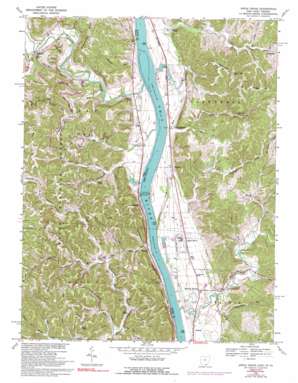
Apple Grove Topo Map Ohio
To zoom in, hover over the map of Apple Grove
USGS Topo Quad 38082f2 - 1:24,000 scale
| Topo Map Name: | Apple Grove |
| USGS Topo Quad ID: | 38082f2 |
| Print Size: | ca. 21 1/4" wide x 27" high |
| Southeast Coordinates: | 38.625° N latitude / 82.125° W longitude |
| Map Center Coordinates: | 38.6875° N latitude / 82.1875° W longitude |
| U.S. States: | OH, WV |
| Filename: | o38082f2.jpg |
| Download Map JPG Image: | Apple Grove topo map 1:24,000 scale |
| Map Type: | Topographic |
| Topo Series: | 7.5´ |
| Map Scale: | 1:24,000 |
| Source of Map Images: | United States Geological Survey (USGS) |
| Alternate Map Versions: |
Apple Grove WV 1958, updated 1961 Download PDF Buy paper map Apple Grove WV 1958, updated 1961 Download PDF Buy paper map Apple Grove WV 1968, updated 1970 Download PDF Buy paper map Apple Grove WV 1968, updated 1977 Download PDF Buy paper map Apple Grove WV 1968, updated 1992 Download PDF Buy paper map Apple Grove WV 2002, updated 2006 Download PDF Buy paper map Apple Grove WV 2011 Download PDF Buy paper map Apple Grove WV 2014 Download PDF Buy paper map Apple Grove WV 2016 Download PDF Buy paper map |
| FStopo: | US Forest Service topo Apple Grove is available: Download FStopo PDF Download FStopo TIF |
1:24,000 Topo Quads surrounding Apple Grove
> Back to 38082e1 at 1:100,000 scale
> Back to 38082a1 at 1:250,000 scale
> Back to U.S. Topo Maps home
Apple Grove topo map: Gazetteer
Apple Grove: Dams
Gallipolis Lock and Dam elevation 162m 531′Gallipolis Lock and Dam elevation 162m 531′
Lock and Dam Number 26 (historical) elevation 163m 534′
Apple Grove: Islands
Raccoon Island (historical) elevation 164m 538′Apple Grove: Populated Places
Angola (historical) elevation 169m 554′Apple Grove elevation 180m 590′
Bladen elevation 172m 564′
Clemma (historical) elevation 176m 577′
Eureka elevation 177m 580′
Halley (historical) elevation 201m 659′
Hogsett elevation 170m 557′
Holiday Hills elevation 173m 567′
Mercers Bottom elevation 178m 583′
Mohrtown elevation 187m 613′
Raccoon Island elevation 174m 570′
Thivener elevation 171m 561′
Apple Grove: Post Offices
Angola Post Office (historical) elevation 170m 557′Apple Grove Post Office elevation 183m 600′
Ashton Post Office elevation 172m 564′
Bladen Post Office (historical) elevation 172m 564′
Clemma Post Office (historical) elevation 175m 574′
Eureka Post Office (historical) elevation 173m 567′
Halley Post Office (historical) elevation 211m 692′
Thivener Post Office (historical) elevation 166m 544′
Apple Grove: Ridges
Pleasant Ridge elevation 268m 879′Shoestring Ridge elevation 240m 787′
Apple Grove: Springs
Garland Mohr Spring elevation 173m 567′George Errington Spring elevation 191m 626′
Lowery Spring elevation 190m 623′
Lowery Spring elevation 191m 626′
Lowery Spring elevation 183m 600′
Lowery Spring elevation 216m 708′
Apple Grove: Streams
Bear Run elevation 164m 538′Bullskin Creek elevation 164m 538′
Burrels Run elevation 165m 541′
Crab Creek elevation 164m 538′
Daves Run elevation 172m 564′
Flatfoot Creek elevation 162m 531′
Fullers Run elevation 164m 538′
Hildebrand Run elevation 162m 531′
Jerrys Run elevation 168m 551′
Middle Fork Crab Creek elevation 170m 557′
Millstone Creek elevation 173m 567′
Mud Run elevation 164m 538′
Peters Branch Swan Creek elevation 171m 561′
Raccoon Creek elevation 164m 538′
Sand Fork Crab Creek elevation 168m 551′
Sardis Run elevation 164m 538′
Sixteenmile Creek elevation 162m 531′
Stonecoal Run elevation 163m 534′
Teens Run elevation 163m 534′
Apple Grove digital topo map on disk
Buy this Apple Grove topo map showing relief, roads, GPS coordinates and other geographical features, as a high-resolution digital map file on DVD:
Western Virginia & Southern West Virginia
Buy digital topo maps: Western Virginia & Southern West Virginia


