Pedro Topo Map Ohio
To zoom in, hover over the map of Pedro
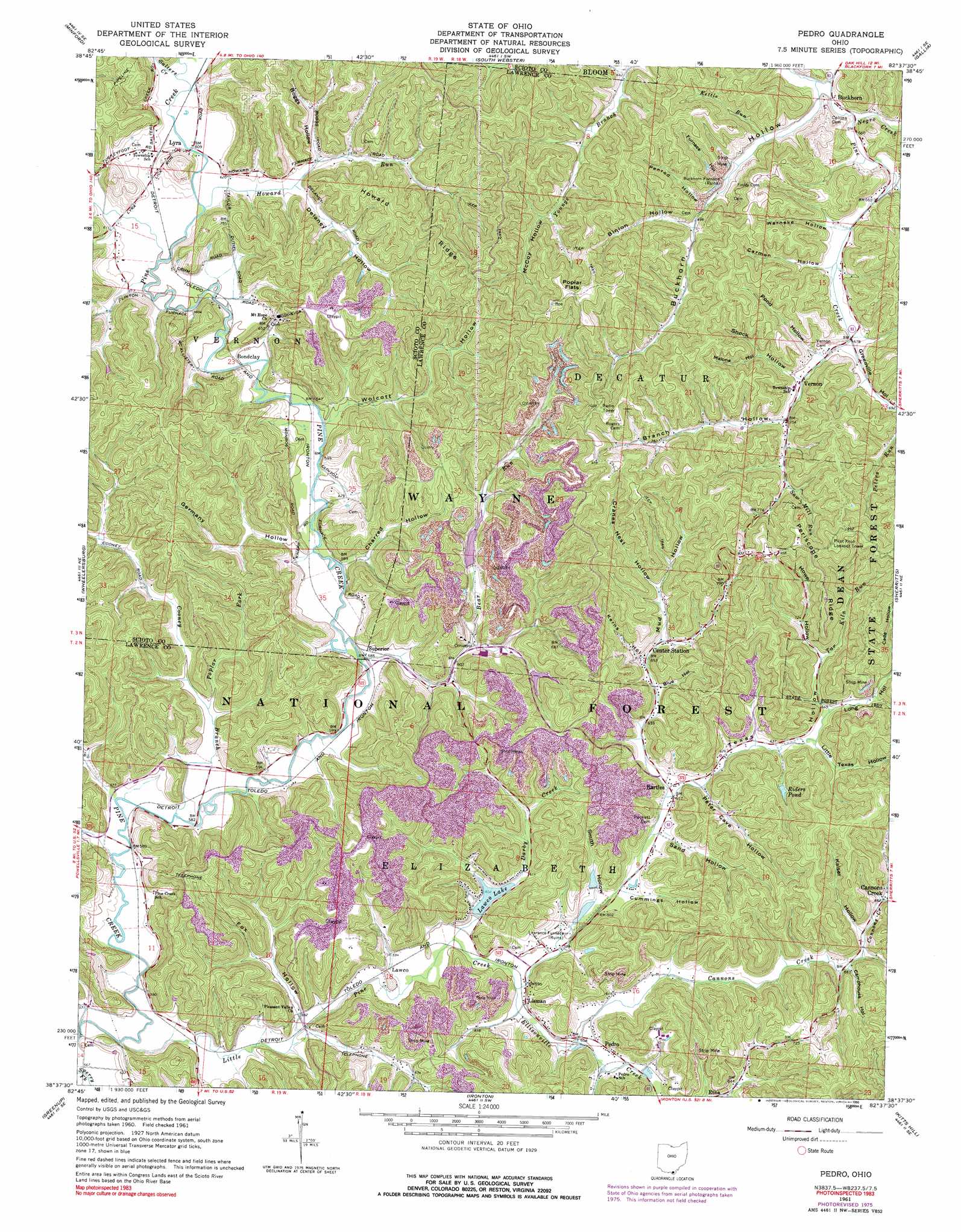
USGS Topo Quad 38082f6 - 1:24,000 scale
| Topo Map Name: | Pedro |
| USGS Topo Quad ID: | 38082f6 |
| Print Size: | ca. 21 1/4" wide x 27" high |
| Southeast Coordinates: | 38.625° N latitude / 82.625° W longitude |
| Map Center Coordinates: | 38.6875° N latitude / 82.6875° W longitude |
| U.S. State: | OH |
| Filename: | o38082f6.jpg |
| Download Map JPG Image: | Pedro topo map 1:24,000 scale |
| Map Type: | Topographic |
| Topo Series: | 7.5´ |
| Map Scale: | 1:24,000 |
| Source of Map Images: | United States Geological Survey (USGS) |
| Alternate Map Versions: |
Pedro OH 1961, updated 1963 Download PDF Buy paper map Pedro OH 1961, updated 1974 Download PDF Buy paper map Pedro OH 1961, updated 1976 Download PDF Buy paper map Pedro OH 1961, updated 1990 Download PDF Buy paper map Pedro OH 2002, updated 2006 Download PDF Buy paper map Pedro OH 2011 Download PDF Buy paper map Pedro OH 2013 Download PDF Buy paper map Pedro OH 2016 Download PDF Buy paper map |
| FStopo: | US Forest Service topo Pedro is available: Download FStopo PDF Download FStopo TIF |
1:24,000 Topo Quads surrounding Pedro
Lucasville |
Stockdale |
Petersburg |
Oak Hill |
Rio Grande |
New Boston |
Minford |
South Webster |
Gallia |
Patriot |
Portsmouth |
Wheelersburg |
Pedro |
Sherritts |
Waterloo |
Load |
Greenup |
Ironton |
Kitts Hill |
Aid |
Oldtown |
Argillite |
Ashland |
Catlettsburg |
Huntington |
> Back to 38082e1 at 1:100,000 scale
> Back to 38082a1 at 1:250,000 scale
> Back to U.S. Topo Maps home
Pedro topo map: Gazetteer
Pedro: Dams
Lawco Lake Dam elevation 184m 603′Marquette Cement Company Dam Number One elevation 220m 721′
Pedro: Flats
Poplar Flats elevation 311m 1020′Pedro: Parks
Dean State Forest elevation 272m 892′Pedro: Populated Places
Andre elevation 188m 616′Bartles elevation 192m 629′
Bondclay elevation 182m 597′
Buckhorn elevation 200m 656′
Buckhorn Furnace elevation 207m 679′
Cannons Creek elevation 215m 705′
Center Station elevation 198m 649′
Dean (historical) elevation 191m 626′
Lawco elevation 185m 606′
Lawrence elevation 183m 600′
Lawrence Furnace elevation 183m 600′
Lisman elevation 183m 600′
Lyra elevation 205m 672′
Moulton (historical) elevation 214m 702′
Pedro elevation 185m 606′
Vernon elevation 210m 688′
Pedro: Post Offices
Buckhorn Post Office (historical) elevation 202m 662′Lyra Post Office (historical) elevation 195m 639′
Pedro Post Office elevation 184m 603′
Pedro: Reservoirs
Lawco Lake elevation 184m 603′Marquette Cement Company Reservoir elevation 220m 721′
Riders Pond elevation 209m 685′
Superior Marquette Cement Company Pond elevation 216m 708′
Pedro: Ridges
Howard Ridge elevation 261m 856′Periscope Ridge elevation 289m 948′
Pedro: Streams
Bear Run elevation 177m 580′Cannons Creek elevation 182m 597′
Cooney Branch elevation 167m 547′
Darby Creek elevation 176m 577′
Ellisonville Creek elevation 178m 583′
Howard Run elevation 186m 610′
Kettle Run elevation 203m 666′
Kimble Creek elevation 219m 718′
Little Pine Creek elevation 172m 564′
Negro Creek elevation 198m 649′
Painter Creek elevation 196m 643′
Poplar Fork elevation 179m 587′
Prickley Ash Creek elevation 176m 577′
Salters Creek elevation 179m 587′
Saw Mill Run elevation 229m 751′
Tar Kiln Run elevation 210m 688′
Turkeyfoot Run elevation 183m 600′
Pedro: Valleys
Binion Hollow elevation 309m 1013′Blue Hollow elevation 200m 656′
Boggs Hollow elevation 186m 610′
Branch Hollow elevation 216m 708′
Buckhorn Hollow elevation 198m 649′
Camphouse Hollow elevation 195m 639′
Carmon Hollow elevation 207m 679′
Charred Hollow elevation 178m 583′
Cranes Nest Hollow elevation 207m 679′
Cummings Hollow elevation 190m 623′
Delaney Hollow elevation 185m 606′
Easter Hollow elevation 219m 718′
Fox Hollow elevation 177m 580′
Furnace Hollow elevation 220m 721′
Germany Hollow elevation 178m 583′
Greenville Hollow elevation 207m 679′
Happy Hollow elevation 195m 639′
Howe Hollow elevation 209m 685′
Kaiser Hollow elevation 199m 652′
Kerns Hollow elevation 197m 646′
Little Texas Hollow elevation 198m 649′
Long Hollow elevation 205m 672′
Malloy Hollow elevation 174m 570′
Malone Hollow elevation 226m 741′
McCoy Hollow elevation 242m 793′
Mud Hollow elevation 201m 659′
Penrod Hollow elevation 212m 695′
Peter Cave Hollow elevation 193m 633′
Pond Hollow elevation 212m 695′
Sand Hollow elevation 189m 620′
Shock Hollow elevation 211m 692′
Smith Hollow elevation 188m 616′
Texas Hollow elevation 197m 646′
Vinegar Hollow elevation 192m 629′
Warneke Hollow elevation 206m 675′
Wolcott Hollow elevation 179m 587′
Pedro digital topo map on disk
Buy this Pedro topo map showing relief, roads, GPS coordinates and other geographical features, as a high-resolution digital map file on DVD:
Western Virginia & Southern West Virginia
Buy digital topo maps: Western Virginia & Southern West Virginia