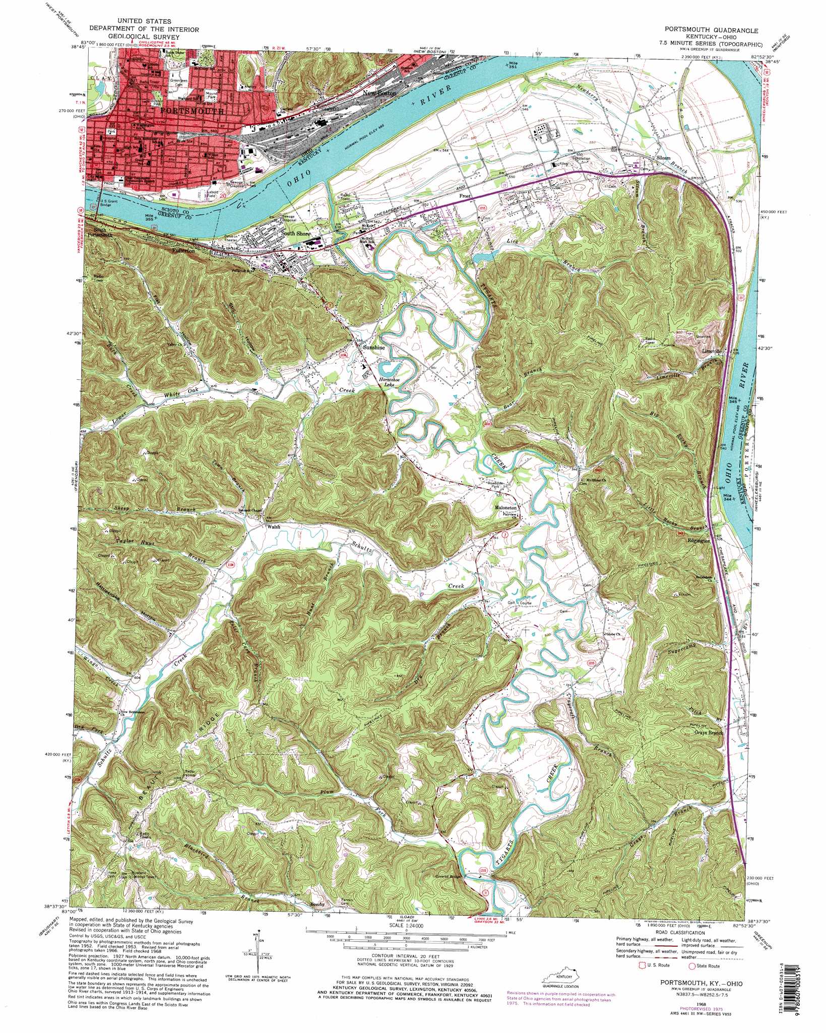
Portsmouth Topo Map Kentucky
To zoom in, hover over the map of Portsmouth
USGS Topo Quad 38082f8 - 1:24,000 scale
| Topo Map Name: | Portsmouth |
| USGS Topo Quad ID: | 38082f8 |
| Print Size: | ca. 21 1/4" wide x 27" high |
| Southeast Coordinates: | 38.625° N latitude / 82.875° W longitude |
| Map Center Coordinates: | 38.6875° N latitude / 82.9375° W longitude |
| U.S. States: | KY, OH |
| Filename: | o38082f8.jpg |
| Download Map JPG Image: | Portsmouth topo map 1:24,000 scale |
| Map Type: | Topographic |
| Topo Series: | 7.5´ |
| Map Scale: | 1:24,000 |
| Source of Map Images: | United States Geological Survey (USGS) |
| Alternate Map Versions: |
Portsmouth OH 1953, updated 1955 Download PDF Buy paper map Portsmouth OH 1953, updated 1965 Download PDF Buy paper map Portsmouth OH 1968, updated 1970 Download PDF Buy paper map Portsmouth OH 1968, updated 1977 Download PDF Buy paper map Portsmouth OH 2010 Download PDF Buy paper map Portsmouth OH 2013 Download PDF Buy paper map Portsmouth OH 2016 Download PDF Buy paper map |
1:24,000 Topo Quads surrounding Portsmouth
Rarden |
Wakefield |
Lucasville |
Stockdale |
Petersburg |
Otway |
West Portsmouth |
New Boston |
Minford |
South Webster |
Pond Run |
Friendship |
Portsmouth |
Wheelersburg |
Pedro |
Garrison |
Brushart |
Load |
Greenup |
Ironton |
Wesleyville |
Tygarts Valley |
Oldtown |
Argillite |
Ashland |
> Back to 38082e1 at 1:100,000 scale
> Back to 38082a1 at 1:250,000 scale
> Back to U.S. Topo Maps home
Portsmouth topo map: Gazetteer
Portsmouth: Bars
Bonanza Bar elevation 148m 485′Portsmouth: Lakes
Horseshoe Lake elevation 158m 518′Portsmouth: Parks
Bannon Park elevation 171m 561′Boneyfiddle Commercial Historic District elevation 162m 531′
Branch Rickey Park elevation 158m 518′
Labold Field elevation 155m 508′
Legion Park elevation 162m 531′
Mound Park elevation 176m 577′
York Park elevation 161m 528′
Portsmouth: Populated Places
Edgington elevation 166m 544′Frost elevation 166m 544′
Fullerton elevation 183m 600′
Grays Branch elevation 164m 538′
Limeville elevation 164m 538′
Maloneton elevation 169m 554′
Portsmouth elevation 162m 531′
Siloam elevation 169m 554′
South Shore elevation 166m 544′
Sunshine elevation 164m 538′
Walsh elevation 170m 557′
Portsmouth: Post Offices
Portsmouth Post Office elevation 162m 531′Portsmouth: Ridges
Beauty Ridge elevation 315m 1033′Portsmouth: Streams
Bear Branch elevation 156m 511′Big Rocky Branch elevation 147m 482′
Buck Creek elevation 182m 597′
Craycraft Branch elevation 159m 521′
Dry Branch elevation 158m 518′
Dry Fork elevation 183m 600′
Hunt Branch elevation 165m 541′
Lick Branch elevation 152m 498′
Limeville Branch elevation 149m 488′
Little Rocky Branch elevation 151m 495′
Lower White Oak Creek elevation 151m 495′
Newberry Branch elevation 150m 492′
Patton Run elevation 150m 492′
Peter Cave Branch elevation 171m 561′
Plum Fork elevation 164m 538′
Schultz Creek elevation 158m 518′
Sheep Branch elevation 168m 551′
Siloam Branch elevation 167m 547′
Taylor Hunt Branch elevation 170m 557′
Town Branch elevation 176m 577′
Tygarts Creek elevation 151m 495′
Wingo Creek elevation 179m 587′
Portsmouth: Valleys
Brewery Hollow elevation 169m 554′Flat Hollow elevation 176m 577′
Mabert Hollow elevation 163m 534′
Rattlesnake Hollow elevation 181m 593′
Still Hollow elevation 171m 561′
Portsmouth digital topo map on disk
Buy this Portsmouth topo map showing relief, roads, GPS coordinates and other geographical features, as a high-resolution digital map file on DVD:
Western Virginia & Southern West Virginia
Buy digital topo maps: Western Virginia & Southern West Virginia