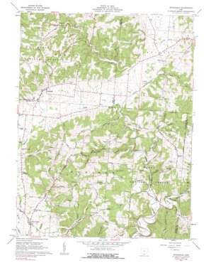
Stockdale Topo Map Ohio
To zoom in, hover over the map of Stockdale
USGS Topo Quad 38082h7 - 1:24,000 scale
| Topo Map Name: | Stockdale |
| USGS Topo Quad ID: | 38082h7 |
| Print Size: | ca. 21 1/4" wide x 27" high |
| Southeast Coordinates: | 38.875° N latitude / 82.75° W longitude |
| Map Center Coordinates: | 38.9375° N latitude / 82.8125° W longitude |
| U.S. State: | OH |
| Filename: | o38082h7.jpg |
| Download Map JPG Image: | Stockdale topo map 1:24,000 scale |
| Map Type: | Topographic |
| Topo Series: | 7.5´ |
| Map Scale: | 1:24,000 |
| Source of Map Images: | United States Geological Survey (USGS) |
| Alternate Map Versions: |
Stockdale OH 1961, updated 1962 Download PDF Buy paper map Stockdale OH 1961, updated 1975 Download PDF Buy paper map Stockdale OH 2010 Download PDF Buy paper map Stockdale OH 2013 Download PDF Buy paper map Stockdale OH 2016 Download PDF Buy paper map |
1:24,000 Topo Quads surrounding Stockdale
> Back to 38082e1 at 1:100,000 scale
> Back to 38082a1 at 1:250,000 scale
> Back to U.S. Topo Maps home
Stockdale topo map: Gazetteer
Stockdale: Bridges
Johnson Road Bridge elevation 189m 620′Stockdale: Populated Places
Massie (historical) elevation 202m 662′Perry Addition elevation 205m 672′
Stockdale elevation 219m 718′
Stockdale: Post Offices
Massie Post Office (historical) elevation 207m 679′Stockdale Post Office elevation 223m 731′
Stockdale: Streams
Brushy Fork elevation 196m 643′Buckhorn Creek elevation 176m 577′
Bucklick Creek elevation 176m 577′
Dry Run elevation 189m 620′
Glade Run elevation 182m 597′
Holland Fork elevation 177m 580′
McConnel Creek elevation 188m 616′
McDowell Creek elevation 189m 620′
Millstone Run elevation 182m 597′
Sugarcamp Creek elevation 177m 580′
Stockdale: Valleys
Dever Valley elevation 177m 580′Irish Hollow elevation 194m 636′
Mill Hollow elevation 180m 590′
Stockdale digital topo map on disk
Buy this Stockdale topo map showing relief, roads, GPS coordinates and other geographical features, as a high-resolution digital map file on DVD:
Western Virginia & Southern West Virginia
Buy digital topo maps: Western Virginia & Southern West Virginia


