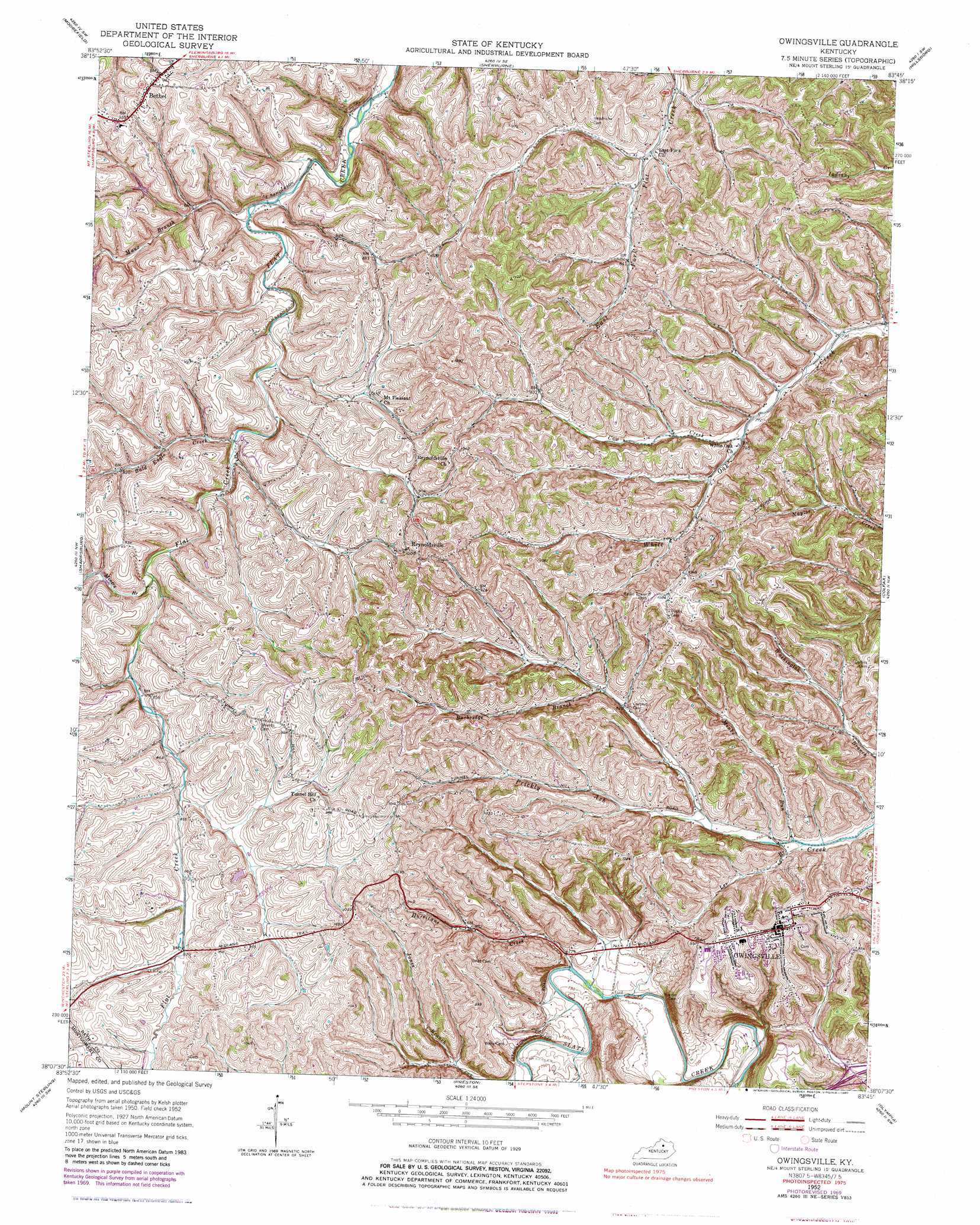
Owingsville Topo Map Kentucky
To zoom in, hover over the map of Owingsville
USGS Topo Quad 38083b7 - 1:24,000 scale
| Topo Map Name: | Owingsville |
| USGS Topo Quad ID: | 38083b7 |
| Print Size: | ca. 21 1/4" wide x 27" high |
| Southeast Coordinates: | 38.125° N latitude / 83.75° W longitude |
| Map Center Coordinates: | 38.1875° N latitude / 83.8125° W longitude |
| U.S. State: | KY |
| Filename: | o38083b7.jpg |
| Download Map JPG Image: | Owingsville topo map 1:24,000 scale |
| Map Type: | Topographic |
| Topo Series: | 7.5´ |
| Map Scale: | 1:24,000 |
| Source of Map Images: | United States Geological Survey (USGS) |
| Alternate Map Versions: |
Owingsville KY 1952, updated 1953 Download PDF Buy paper map Owingsville KY 1952, updated 1970 Download PDF Buy paper map Owingsville KY 1952, updated 1971 Download PDF Buy paper map Owingsville KY 1952, updated 1980 Download PDF Buy paper map Owingsville KY 2010 Download PDF Buy paper map Owingsville KY 2013 Download PDF Buy paper map Owingsville KY 2016 Download PDF Buy paper map |
1:24,000 Topo Quads surrounding Owingsville
Piqua |
Cowan |
Elizaville |
Flemingsburg |
Burtonville |
Carlisle |
Moorefield |
Sherburne |
Hillsboro |
Plummers Landing |
North Middletown |
Sharpsburg |
Owingsville |
Colfax |
Farmers |
Sideview |
Mount Sterling |
Preston |
Olympia |
Salt Lick |
Hedges |
Levee |
Means |
Frenchburg |
Scranton |
> Back to 38083a1 at 1:100,000 scale
> Back to 38082a1 at 1:250,000 scale
> Back to U.S. Topo Maps home
Owingsville topo map: Gazetteer
Owingsville: Bridges
Bald Eagle Bridge elevation 237m 777′Owingsville: Populated Places
Bald Eagle elevation 241m 790′Bethel elevation 286m 938′
East Fork elevation 241m 790′
Harpers elevation 257m 843′
Needmore elevation 239m 784′
Owingsville elevation 306m 1003′
Pittsburgh elevation 247m 810′
Reynoldsville elevation 310m 1017′
Upper Prickly Ash elevation 269m 882′
Upper White Oak elevation 239m 784′
Owingsville: Post Offices
Bald Eagle Post Office (historical) elevation 243m 797′Bath County Post Office elevation 306m 1003′
Bethel Post Office (historical) elevation 285m 935′
Eastville Post Office (historical) elevation 241m 790′
Odessa Post Office (historical) elevation 217m 711′
Pittsburgh Post Office (historical) elevation 247m 810′
Reynoldsville Post Office (historical) elevation 310m 1017′
Owingsville: Streams
Bald Eagle Creek elevation 237m 777′Burbridge Branch elevation 253m 830′
Cow Creek elevation 239m 784′
Hurricane Creek elevation 216m 708′
Lee Branch elevation 224m 734′
Maux Branch elevation 218m 715′
Miners Branch elevation 243m 797′
Minks Run elevation 226m 741′
North Prong Prickly Ash Creek elevation 265m 869′
Owingsville: Summits
Tunnel Hill elevation 300m 984′White Oak Hill elevation 327m 1072′
Owingsville digital topo map on disk
Buy this Owingsville topo map showing relief, roads, GPS coordinates and other geographical features, as a high-resolution digital map file on DVD:
Western Virginia & Southern West Virginia
Buy digital topo maps: Western Virginia & Southern West Virginia