Sardis Topo Map Kentucky
To zoom in, hover over the map of Sardis
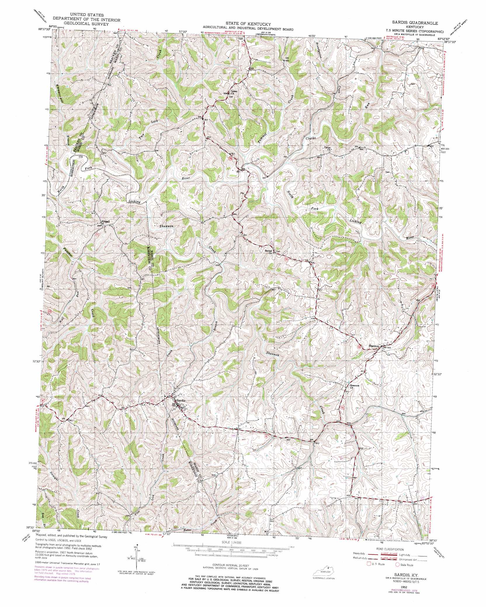
USGS Topo Quad 38083e8 - 1:24,000 scale
| Topo Map Name: | Sardis |
| USGS Topo Quad ID: | 38083e8 |
| Print Size: | ca. 21 1/4" wide x 27" high |
| Southeast Coordinates: | 38.5° N latitude / 83.875° W longitude |
| Map Center Coordinates: | 38.5625° N latitude / 83.9375° W longitude |
| U.S. State: | KY |
| Filename: | o38083e8.jpg |
| Download Map JPG Image: | Sardis topo map 1:24,000 scale |
| Map Type: | Topographic |
| Topo Series: | 7.5´ |
| Map Scale: | 1:24,000 |
| Source of Map Images: | United States Geological Survey (USGS) |
| Alternate Map Versions: |
Sardis KY 1952, updated 1953 Download PDF Buy paper map Sardis KY 1952, updated 1978 Download PDF Buy paper map Sardis KY 2010 Download PDF Buy paper map Sardis KY 2013 Download PDF Buy paper map Sardis KY 2016 Download PDF Buy paper map |
1:24,000 Topo Quads surrounding Sardis
Moscow |
Felicity |
Higginsport |
Russellville |
Decatur |
Berlin |
Brooksville |
Germantown |
Maysville West |
Maysville East |
Claysville |
Mount Olivet |
Sardis |
Mays Lick |
Orangeburg |
Shady Nook |
Piqua |
Cowan |
Elizaville |
Flemingsburg |
Millersburg |
Carlisle |
Moorefield |
Sherburne |
Hillsboro |
> Back to 38083e1 at 1:100,000 scale
> Back to 38082a1 at 1:250,000 scale
> Back to U.S. Topo Maps home
Sardis topo map: Gazetteer
Sardis: Airports
Tennessee Gas Heliport elevation 233m 764′Sardis: Populated Places
Abigail elevation 271m 889′Dexter (historical) elevation 237m 777′
Five Lick Creek (historical) elevation 224m 734′
Manley (historical) elevation 284m 931′
Ogden Ridge (historical) elevation 244m 800′
Sardis elevation 291m 954′
Shannon elevation 280m 918′
Sardis: Post Offices
Abigail Post Office (historical) elevation 271m 889′Bromel Post Office (historical) elevation 283m 928′
Kennard Post Office (historical) elevation 210m 688′
Needmore Post Office (historical) elevation 245m 803′
Sardis Post Office (historical) elevation 288m 944′
Shannon Post Office (historical) elevation 286m 938′
Sardis: Ridges
Ogden Ridge elevation 282m 925′Sardis: Streams
Brandywine Creek elevation 204m 669′Clarks Run elevation 199m 652′
Pommel Creek elevation 198m 649′
Shannon Creek elevation 194m 636′
Smith Branch elevation 212m 695′
Two Lick Creek elevation 194m 636′
Whippoorwill Branch elevation 194m 636′
Wolf Run elevation 204m 669′
Sardis digital topo map on disk
Buy this Sardis topo map showing relief, roads, GPS coordinates and other geographical features, as a high-resolution digital map file on DVD:
Western Virginia & Southern West Virginia
Buy digital topo maps: Western Virginia & Southern West Virginia