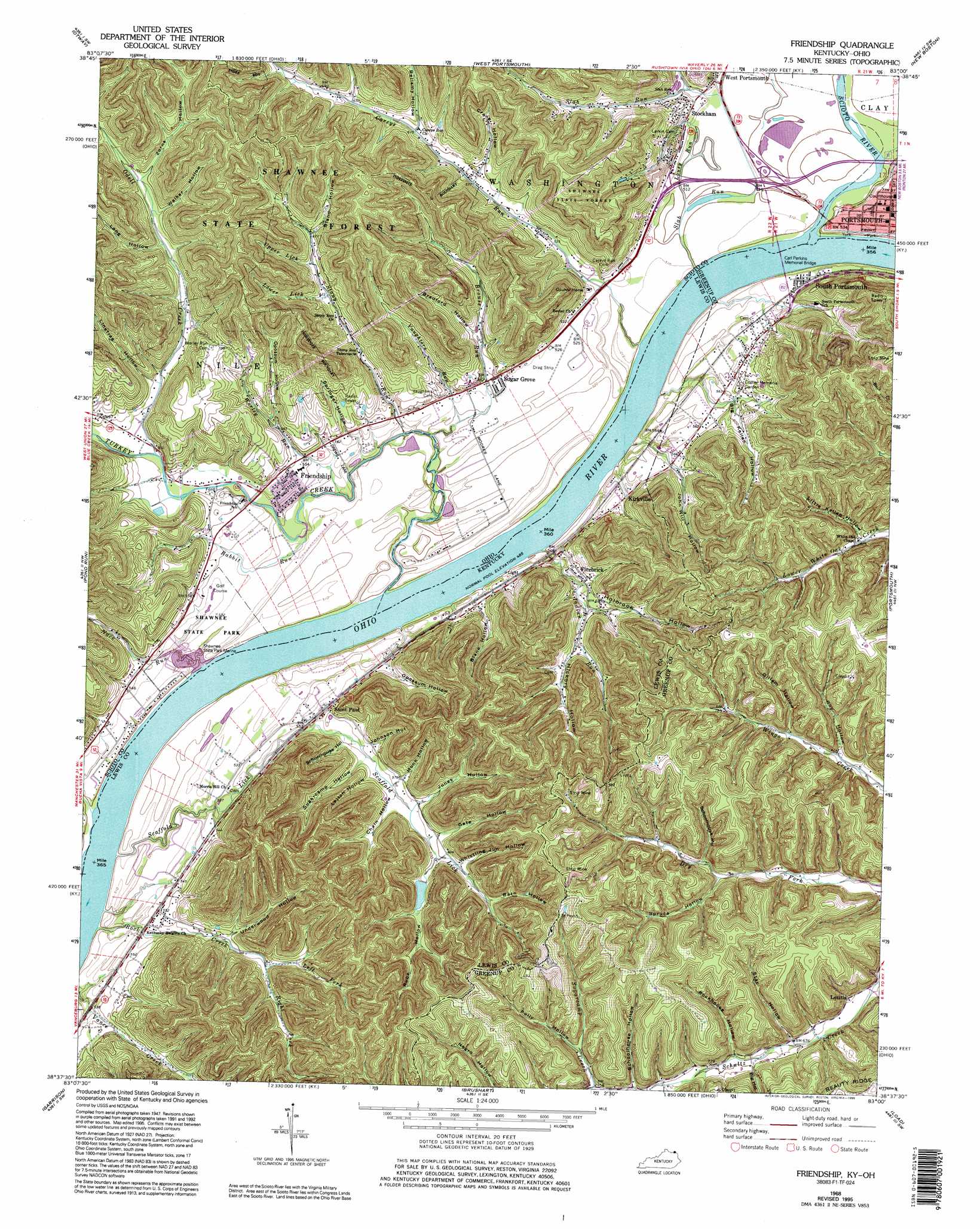
Friendship Topo Map Kentucky
To zoom in, hover over the map of Friendship
USGS Topo Quad 38083f1 - 1:24,000 scale
| Topo Map Name: | Friendship |
| USGS Topo Quad ID: | 38083f1 |
| Print Size: | ca. 21 1/4" wide x 27" high |
| Southeast Coordinates: | 38.625° N latitude / 83° W longitude |
| Map Center Coordinates: | 38.6875° N latitude / 83.0625° W longitude |
| U.S. States: | KY, OH |
| Filename: | o38083f1.jpg |
| Download Map JPG Image: | Friendship topo map 1:24,000 scale |
| Map Type: | Topographic |
| Topo Series: | 7.5´ |
| Map Scale: | 1:24,000 |
| Source of Map Images: | United States Geological Survey (USGS) |
| Alternate Map Versions: |
Friendship OH 1949, updated 1962 Download PDF Buy paper map Friendship OH 1951 Download PDF Buy paper map Friendship OH 1951 Download PDF Buy paper map Friendship OH 1968, updated 1970 Download PDF Buy paper map Friendship OH 1968, updated 1976 Download PDF Buy paper map Friendship OH 1968, updated 1995 Download PDF Buy paper map Friendship OH 2010 Download PDF Buy paper map Friendship OH 2013 Download PDF Buy paper map Friendship OH 2016 Download PDF Buy paper map |
1:24,000 Topo Quads surrounding Friendship
Jaybird |
Rarden |
Wakefield |
Lucasville |
Stockdale |
Blue Creek |
Otway |
West Portsmouth |
New Boston |
Minford |
Buena Vista |
Pond Run |
Friendship |
Portsmouth |
Wheelersburg |
Vanceburg |
Garrison |
Brushart |
Load |
Greenup |
Head Of Grassy |
Wesleyville |
Tygarts Valley |
Oldtown |
Argillite |
> Back to 38083e1 at 1:100,000 scale
> Back to 38082a1 at 1:250,000 scale
> Back to U.S. Topo Maps home
Friendship topo map: Gazetteer
Friendship: Airports
Shawnee Airport elevation 162m 531′Friendship: Bridges
Carl Perkins Memorial Bridge elevation 148m 485′Friendship: Dams
Lock and Dam Number 31 (historical) elevation 150m 492′Friendship: Parks
Earl Thomas Conley Riverside Park elevation 160m 524′Riverfront Park elevation 160m 524′
Second Street Historic District elevation 161m 528′
Sixth Street Historic District elevation 161m 528′
Friendship: Populated Places
Alexandria elevation 156m 511′Dennis elevation 159m 521′
Firebrick elevation 181m 593′
Friendship elevation 168m 551′
Kirkville elevation 173m 567′
Letitia elevation 202m 662′
Saint Paul elevation 165m 541′
Shannoah Town (historical) elevation 160m 524′
South Portsmouth elevation 169m 554′
Stockham elevation 160m 524′
Sugar Grove elevation 162m 531′
Friendship: Post Offices
Alexandria Post Office (historical) elevation 159m 521′Dennis Post Office (historical) elevation 160m 524′
Firebrick Post Office (historical) elevation 176m 577′
Friendship Post Office elevation 168m 551′
Saint Pauls Post Office (historical) elevation 165m 541′
Friendship: Streams
Bellamy Run elevation 188m 616′Bronze Run elevation 153m 501′
Brouse Run elevation 152m 498′
Careys Run elevation 152m 498′
Hygean Run elevation 161m 528′
Indian Run elevation 152m 498′
Left Fork Rock Creek elevation 191m 626′
Lousy Run elevation 152m 498′
Lower Lick elevation 202m 662′
Nace Run elevation 152m 498′
Odell Creek elevation 164m 538′
Pond Run elevation 149m 488′
Rabbit Run elevation 162m 531′
Right Fork Rock Creek elevation 190m 623′
Rock Creek elevation 249m 816′
Rock Creek elevation 151m 495′
Scaffold Lick elevation 153m 501′
Scioto River elevation 150m 492′
Slab Run elevation 151m 495′
Spellacy Run elevation 152m 498′
Stony Run elevation 150m 492′
Sulphur Lick elevation 201m 659′
Turkey Creek elevation 152m 498′
Upper Lick elevation 198m 649′
Vaughters Run elevation 156m 511′
Worley Run elevation 154m 505′
Friendship: Valleys
Barn Hollow elevation 203m 666′Bellamy Hollow elevation 188m 616′
Big Hollow elevation 224m 734′
Big Kellen Hollow elevation 171m 561′
Bland Hollow elevation 218m 715′
Blane Hollow elevation 167m 547′
Bradford Hollow elevation 173m 567′
Chain Hollow elevation 170m 557′
Crane Hollow elevation 205m 672′
Gate Hollow elevation 186m 610′
Gillem Hollow elevation 218m 715′
Hickory Hollow elevation 186m 610′
Holbrook Hollow elevation 180m 590′
John Will Hollow elevation 177m 580′
Johnson Hollow elevation 174m 570′
Jones Hollow elevation 177m 580′
Leitch Hollow elevation 170m 557′
Linetree Hollow elevation 177m 580′
Little Kellen Hollow elevation 207m 679′
Long Hollow elevation 199m 652′
Monk Hollow elevation 181m 593′
Opossum Hollow elevation 167m 547′
Opossum Hollow elevation 170m 557′
Polly Hollow elevation 239m 784′
Rockhouse Hollow elevation 212m 695′
Roy Hollow elevation 203m 666′
Rube Hollow elevation 182m 597′
Schoolhouse Hollow elevation 227m 744′
Schoolhouse Hollow elevation 225m 738′
Schoolhouse Hollow elevation 166m 544′
Springer Hollow elevation 179m 587′
Spruce Hollow elevation 228m 748′
Star Hollow elevation 201m 659′
Sugarcamp Hollow elevation 172m 564′
Underwood Hollow elevation 183m 600′
Walker Hollow elevation 215m 705′
Whistling Jim Hollow elevation 191m 626′
Zorns Hollow elevation 212m 695′
Friendship digital topo map on disk
Buy this Friendship topo map showing relief, roads, GPS coordinates and other geographical features, as a high-resolution digital map file on DVD:
Western Virginia & Southern West Virginia
Buy digital topo maps: Western Virginia & Southern West Virginia