Buena Vista Topo Map Ohio
To zoom in, hover over the map of Buena Vista
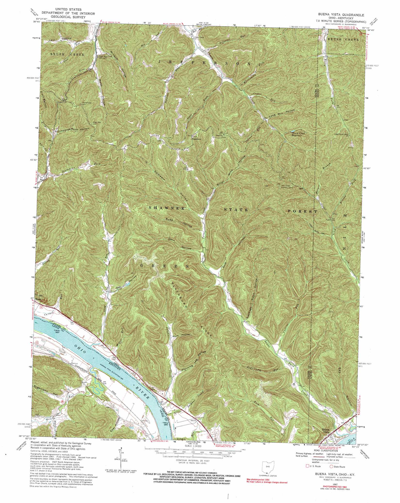
USGS Topo Quad 38083f3 - 1:24,000 scale
| Topo Map Name: | Buena Vista |
| USGS Topo Quad ID: | 38083f3 |
| Print Size: | ca. 21 1/4" wide x 27" high |
| Southeast Coordinates: | 38.625° N latitude / 83.25° W longitude |
| Map Center Coordinates: | 38.6875° N latitude / 83.3125° W longitude |
| U.S. States: | OH, KY |
| Filename: | o38083f3.jpg |
| Download Map JPG Image: | Buena Vista topo map 1:24,000 scale |
| Map Type: | Topographic |
| Topo Series: | 7.5´ |
| Map Scale: | 1:24,000 |
| Source of Map Images: | United States Geological Survey (USGS) |
| Alternate Map Versions: |
Buena Vista OH 1949, updated 1964 Download PDF Buy paper map Buena Vista OH 1951 Download PDF Buy paper map Buena Vista OH 1967, updated 1969 Download PDF Buy paper map Buena Vista OH 1967, updated 1990 Download PDF Buy paper map Buena Vista OH 2010 Download PDF Buy paper map Buena Vista OH 2013 Download PDF Buy paper map Buena Vista OH 2016 Download PDF Buy paper map |
1:24,000 Topo Quads surrounding Buena Vista
Seaman |
Peebles |
Jaybird |
Rarden |
Wakefield |
West Union |
Lynx |
Blue Creek |
Otway |
West Portsmouth |
Manchester Islands |
Concord |
Buena Vista |
Pond Run |
Friendship |
Tollesboro |
Charters |
Vanceburg |
Garrison |
Brushart |
Burtonville |
Stricklett |
Head Of Grassy |
Wesleyville |
Tygarts Valley |
> Back to 38083e1 at 1:100,000 scale
> Back to 38082a1 at 1:250,000 scale
> Back to U.S. Topo Maps home
Buena Vista topo map: Gazetteer
Buena Vista: Bars
Twin Creek Bar elevation 151m 495′Buena Vista: Dams
Dam Number 32 elevation 147m 482′Lock and Dam Number 32 (historical) elevation 147m 482′
Buena Vista: Populated Places
Buena Vista elevation 267m 875′Selig elevation 232m 761′
Sunshine elevation 357m 1171′
Buena Vista: Post Offices
Buena Vista Post Office (historical) elevation 260m 853′Halbert Post Office (historical) elevation 151m 495′
Buena Vista: Reservoirs
Churn Creek Reservoir elevation 303m 994′Buena Vista: Ridges
Blackburn Ridge elevation 342m 1122′Buena Vista: Streams
Black Walnut Fork Stout Creek elevation 204m 669′Blood Lick elevation 158m 518′
Bolander Run elevation 228m 748′
Brushy Fork Upper Twin Creek elevation 268m 879′
Buttermilk Fork Churn Creek elevation 240m 787′
Carter Run elevation 260m 853′
Coffer Run elevation 258m 846′
Glen Run elevation 226m 741′
Hall Fork elevation 218m 715′
Horner Branch Upper Twin Creek elevation 282m 925′
Johnson Run elevation 220m 721′
Little Sulphur Creek elevation 149m 488′
Long Lick Run elevation 151m 495′
Lower Twin Creek elevation 152m 498′
Minque Run elevation 230m 754′
Moon Run elevation 237m 777′
Pine Fork elevation 228m 748′
Quicks Run elevation 152m 498′
Slate Fork Churn Creek elevation 239m 784′
Southdown Fork Stout Run elevation 180m 590′
Sugarcamp Run elevation 171m 561′
Sulphur Creek elevation 151m 495′
Vastine Run elevation 186m 610′
Wikoff Run elevation 151m 495′
Wyckoffs Run elevation 148m 485′
Buena Vista: Valleys
Bond Hollow elevation 199m 652′Cabbage Patch Hollow elevation 193m 633′
Coal Hollow elevation 172m 564′
Copperas Rock Hollow elevation 214m 702′
Corn Hollow elevation 215m 705′
Demazie Hollow elevation 226m 741′
Gas Hollow elevation 159m 521′
Gum Hollow elevation 207m 679′
Little Gum Hollow elevation 275m 902′
Minque Hollow elevation 240m 787′
Moon Hollow elevation 238m 780′
Owl Hollow elevation 172m 564′
Rube Hollow elevation 223m 731′
Silver Mine Hollow elevation 257m 843′
Stocking Leg Hollow elevation 177m 580′
Sugarcamp Hollow elevation 159m 521′
Buena Vista digital topo map on disk
Buy this Buena Vista topo map showing relief, roads, GPS coordinates and other geographical features, as a high-resolution digital map file on DVD:
Western Virginia & Southern West Virginia
Buy digital topo maps: Western Virginia & Southern West Virginia