West Union Topo Map Ohio
To zoom in, hover over the map of West Union
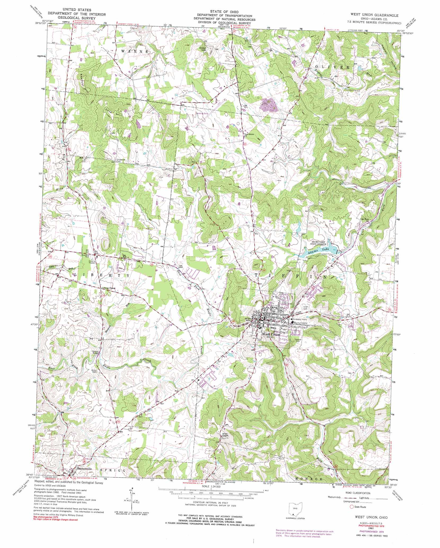
USGS Topo Quad 38083g5 - 1:24,000 scale
| Topo Map Name: | West Union |
| USGS Topo Quad ID: | 38083g5 |
| Print Size: | ca. 21 1/4" wide x 27" high |
| Southeast Coordinates: | 38.75° N latitude / 83.5° W longitude |
| Map Center Coordinates: | 38.8125° N latitude / 83.5625° W longitude |
| U.S. State: | OH |
| Filename: | o38083g5.jpg |
| Download Map JPG Image: | West Union topo map 1:24,000 scale |
| Map Type: | Topographic |
| Topo Series: | 7.5´ |
| Map Scale: | 1:24,000 |
| Source of Map Images: | United States Geological Survey (USGS) |
| Alternate Map Versions: |
West Union OH 1961, updated 1962 Download PDF Buy paper map West Union OH 1961, updated 1975 Download PDF Buy paper map West Union OH 1961, updated 1991 Download PDF Buy paper map West Union OH 2010 Download PDF Buy paper map West Union OH 2013 Download PDF Buy paper map West Union OH 2016 Download PDF Buy paper map |
1:24,000 Topo Quads surrounding West Union
Sardinia |
Sugar Tree Ridge |
Belfast |
Sinking Spring |
Byington |
Ash Ridge |
Winchester |
Seaman |
Peebles |
Jaybird |
Russellville |
Decatur |
West Union |
Lynx |
Blue Creek |
Maysville West |
Maysville East |
Manchester Islands |
Concord |
Buena Vista |
Mays Lick |
Orangeburg |
Tollesboro |
Charters |
Vanceburg |
> Back to 38083e1 at 1:100,000 scale
> Back to 38082a1 at 1:250,000 scale
> Back to U.S. Topo Maps home
West Union topo map: Gazetteer
West Union: Airports
Adams County Hospital Heliport elevation 305m 1000′Alexander Salamon Airport elevation 267m 875′
West Union: Bridges
Kirker Bridge elevation 243m 797′West Union: Dams
Adams Lake Dam elevation 232m 761′Dodge Pond Dam elevation 286m 938′
West Union: Parks
Adams Lake State Park elevation 236m 774′Chaparral Prairie Nature Preserve elevation 281m 921′
Johnson Ridge State Nature Preserve elevation 292m 958′
West Union: Populated Places
Panhandle elevation 285m 935′West Union elevation 290m 951′
Whippoorwill elevation 203m 666′
West Union: Post Offices
West Union Post Office elevation 291m 954′West Union: Reservoirs
Adams Lake elevation 232m 761′Dodge Pond elevation 286m 938′
West Union: Streams
Hannah Run elevation 243m 797′West Union: Summits
Cave Hill elevation 338m 1108′Coon Hill elevation 309m 1013′
Spencer Hill elevation 336m 1102′
West Union digital topo map on disk
Buy this West Union topo map showing relief, roads, GPS coordinates and other geographical features, as a high-resolution digital map file on DVD:
Western Virginia & Southern West Virginia
Buy digital topo maps: Western Virginia & Southern West Virginia