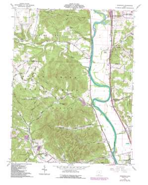
Wakefield Topo Map Ohio
To zoom in, hover over the map of Wakefield
USGS Topo Quad 38083h1 - 1:24,000 scale
| Topo Map Name: | Wakefield |
| USGS Topo Quad ID: | 38083h1 |
| Print Size: | ca. 21 1/4" wide x 27" high |
| Southeast Coordinates: | 38.875° N latitude / 83° W longitude |
| Map Center Coordinates: | 38.9375° N latitude / 83.0625° W longitude |
| U.S. State: | OH |
| Filename: | o38083h1.jpg |
| Download Map JPG Image: | Wakefield topo map 1:24,000 scale |
| Map Type: | Topographic |
| Topo Series: | 7.5´ |
| Map Scale: | 1:24,000 |
| Source of Map Images: | United States Geological Survey (USGS) |
| Alternate Map Versions: |
Wakefield OH 1961, updated 1963 Download PDF Buy paper map Wakefield OH 1961, updated 1976 Download PDF Buy paper map Wakefield OH 1961, updated 1987 Download PDF Buy paper map Wakefield OH 2010 Download PDF Buy paper map Wakefield OH 2013 Download PDF Buy paper map Wakefield OH 2016 Download PDF Buy paper map |
1:24,000 Topo Quads surrounding Wakefield
> Back to 38083e1 at 1:100,000 scale
> Back to 38082a1 at 1:250,000 scale
> Back to U.S. Topo Maps home
Wakefield topo map: Gazetteer
Wakefield: Airports
Hidden Quarry Airport elevation 254m 833′Wakefield: Dams
Lake Frasure Dam elevation 163m 534′Wakefield: Populated Places
Bear Creek elevation 195m 639′Bonds Trailer Court elevation 164m 538′
Camp elevation 188m 616′
Clifford elevation 177m 580′
Coopersville elevation 160m 524′
Crabtree elevation 222m 728′
Dawsons Mobile Home Park elevation 170m 557′
Sedan elevation 240m 787′
Wakefield elevation 167m 547′
Wetmore elevation 174m 570′
Wakefield: Post Offices
Bearcreek Post Office (historical) elevation 184m 603′Camp Post Office (historical) elevation 188m 616′
Clifford Post Office (historical) elevation 178m 583′
Coopersville Post Office (historical) elevation 159m 521′
Crabtree Post Office (historical) elevation 223m 731′
Sedan Post Office (historical) elevation 241m 790′
Wakefield Post Office elevation 169m 554′
Wetmore Post Office (historical) elevation 181m 593′
Wakefield: Reservoirs
Lake Frasure elevation 163m 534′Wakefield: Ridges
McChesney Ridge elevation 293m 961′Wakefield: Streams
Bear Creek elevation 159m 521′Big Run elevation 161m 528′
Big Run elevation 156m 511′
Camp Creek elevation 161m 528′
Devers Run elevation 156m 511′
Ganderhook Creek elevation 160m 524′
Miller Run elevation 158m 518′
Rocky Fork elevation 176m 577′
Salt Creek elevation 166m 544′
Slate Run elevation 159m 521′
Wakefield: Summits
Goldust Hill elevation 240m 787′Henderson Knob elevation 282m 925′
Wakefield: Valleys
Bean Hollow elevation 195m 639′Hiles Hollow elevation 185m 606′
Rapp Hollow elevation 177m 580′
Starr Hollow elevation 169m 554′
Wheeler Hollow elevation 177m 580′
Wildcat Hollow elevation 196m 643′
Wakefield digital topo map on disk
Buy this Wakefield topo map showing relief, roads, GPS coordinates and other geographical features, as a high-resolution digital map file on DVD:
Western Virginia & Southern West Virginia
Buy digital topo maps: Western Virginia & Southern West Virginia


