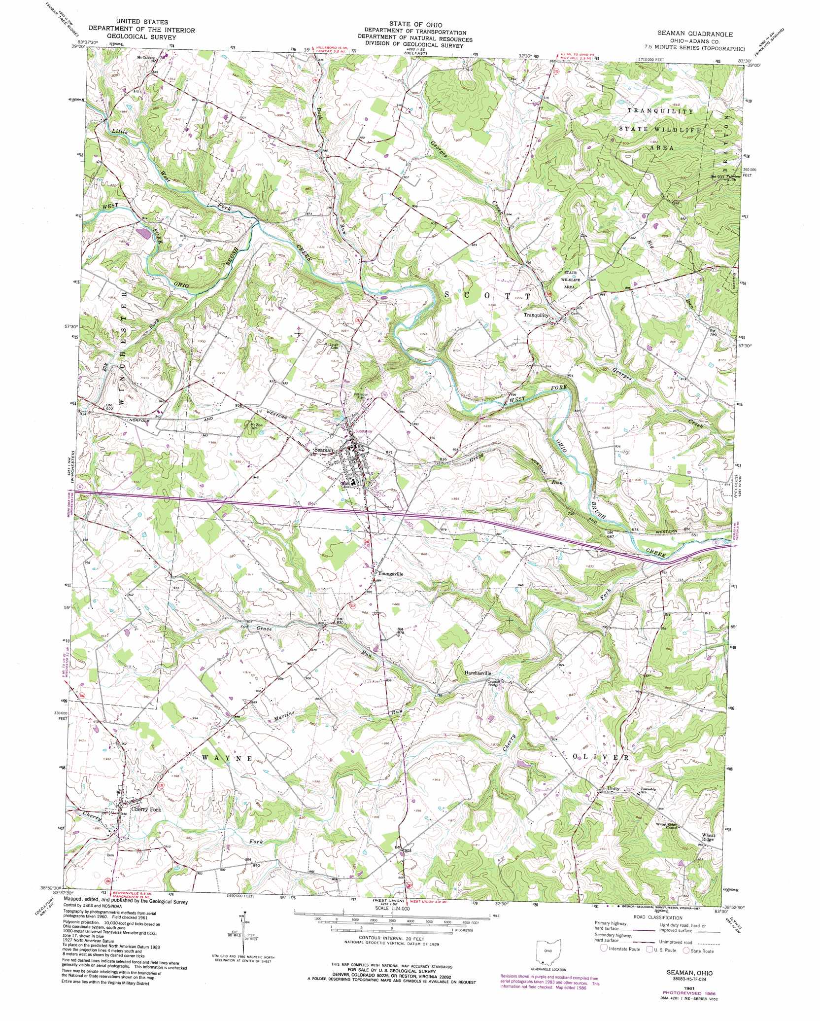
Seaman Topo Map Ohio
To zoom in, hover over the map of Seaman
USGS Topo Quad 38083h5 - 1:24,000 scale
| Topo Map Name: | Seaman |
| USGS Topo Quad ID: | 38083h5 |
| Print Size: | ca. 21 1/4" wide x 27" high |
| Southeast Coordinates: | 38.875° N latitude / 83.5° W longitude |
| Map Center Coordinates: | 38.9375° N latitude / 83.5625° W longitude |
| U.S. State: | OH |
| Filename: | o38083h5.jpg |
| Download Map JPG Image: | Seaman topo map 1:24,000 scale |
| Map Type: | Topographic |
| Topo Series: | 7.5´ |
| Map Scale: | 1:24,000 |
| Source of Map Images: | United States Geological Survey (USGS) |
| Alternate Map Versions: |
Seaman OH 1961, updated 1962 Download PDF Buy paper map Seaman OH 1961, updated 1975 Download PDF Buy paper map Seaman OH 1961, updated 1982 Download PDF Buy paper map Seaman OH 1961, updated 1987 Download PDF Buy paper map Seaman OH 2010 Download PDF Buy paper map Seaman OH 2013 Download PDF Buy paper map Seaman OH 2016 Download PDF Buy paper map |
1:24,000 Topo Quads surrounding Seaman
Lynchburg |
New Market |
Hillsboro |
Rainsboro |
Bainbridge |
Sardinia |
Sugar Tree Ridge |
Belfast |
Sinking Spring |
Byington |
Ash Ridge |
Winchester |
Seaman |
Peebles |
Jaybird |
Russellville |
Decatur |
West Union |
Lynx |
Blue Creek |
Maysville West |
Maysville East |
Manchester Islands |
Concord |
Buena Vista |
> Back to 38083e1 at 1:100,000 scale
> Back to 38082a1 at 1:250,000 scale
> Back to U.S. Topo Maps home
Seaman topo map: Gazetteer
Seaman: Bridges
Harshasville Bridge elevation 219m 718′Seaman: Populated Places
Buck Run (historical) elevation 242m 793′Cherry Fork elevation 274m 898′
Harshasville elevation 220m 721′
Irvington (historical) elevation 248m 813′
Mount Leigh (historical) elevation 263m 862′
Mount Zion (historical) elevation 296m 971′
Seaman elevation 276m 905′
Tranquility elevation 236m 774′
Unity elevation 290m 951′
Wheat Ridge elevation 289m 948′
Youngsville elevation 270m 885′
Seaman: Post Offices
Buck Run Post Office (historical) elevation 242m 793′Cherry Fork Post Office elevation 274m 898′
Harshasville Post Office (historical) elevation 223m 731′
Irvington Post Office (historical) elevation 248m 813′
Mount Leigh Post Office (historical) elevation 263m 862′
Seaman Post Office elevation 279m 915′
Tranquillity Post Office (historical) elevation 236m 774′
Seaman: Streams
Buck Run elevation 221m 725′Cherry Fork elevation 193m 633′
Elk Fork elevation 236m 774′
Grace Run elevation 217m 711′
Gregg Run elevation 194m 636′
Little West Fork Ohio Brush Creek elevation 230m 754′
Martins Run elevation 231m 757′
Seaman digital topo map on disk
Buy this Seaman topo map showing relief, roads, GPS coordinates and other geographical features, as a high-resolution digital map file on DVD:
Western Virginia & Southern West Virginia
Buy digital topo maps: Western Virginia & Southern West Virginia