Piqua Topo Map Kentucky
To zoom in, hover over the map of Piqua
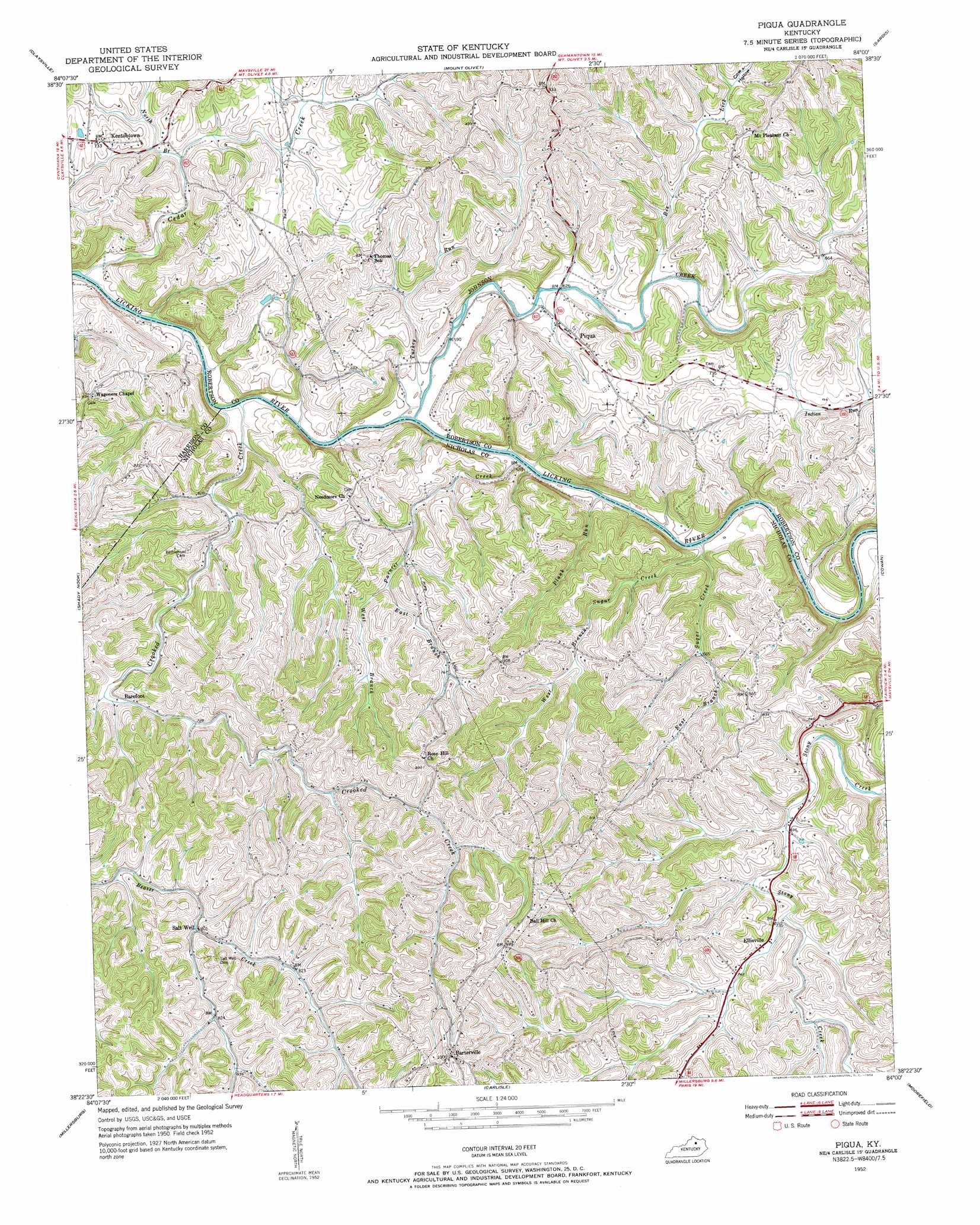
USGS Topo Quad 38084d1 - 1:24,000 scale
| Topo Map Name: | Piqua |
| USGS Topo Quad ID: | 38084d1 |
| Print Size: | ca. 21 1/4" wide x 27" high |
| Southeast Coordinates: | 38.375° N latitude / 84° W longitude |
| Map Center Coordinates: | 38.4375° N latitude / 84.0625° W longitude |
| U.S. State: | KY |
| Filename: | o38084d1.jpg |
| Download Map JPG Image: | Piqua topo map 1:24,000 scale |
| Map Type: | Topographic |
| Topo Series: | 7.5´ |
| Map Scale: | 1:24,000 |
| Source of Map Images: | United States Geological Survey (USGS) |
| Alternate Map Versions: |
Piqua KY 1952, updated 1954 Download PDF Buy paper map Piqua KY 2010 Download PDF Buy paper map Piqua KY 2013 Download PDF Buy paper map Piqua KY 2016 Download PDF Buy paper map |
1:24,000 Topo Quads surrounding Piqua
Falmouth |
Berlin |
Brooksville |
Germantown |
Maysville West |
Kelat |
Claysville |
Mount Olivet |
Sardis |
Mays Lick |
Cynthiana |
Shady Nook |
Piqua |
Cowan |
Elizaville |
Shawhan |
Millersburg |
Carlisle |
Moorefield |
Sherburne |
Paris West |
Paris East |
North Middletown |
Sharpsburg |
Owingsville |
> Back to 38084a1 at 1:100,000 scale
> Back to 38084a1 at 1:250,000 scale
> Back to U.S. Topo Maps home
Piqua topo map: Gazetteer
Piqua: Bridges
Jim Berry Iron Bridge elevation 199m 652′Piqua Bridge elevation 186m 610′
Piqua: Crossings
Days Ferry (historical) elevation 174m 570′Piqua: Populated Places
Barefoot elevation 220m 721′Barterville elevation 307m 1007′
Ellisville elevation 228m 748′
Kentontown elevation 221m 725′
Mount Pleasant (historical) elevation 255m 836′
Piqua elevation 215m 705′
Piqua: Post Offices
Barefoot Post Office (historical) elevation 220m 721′Barterville Post Office (historical) elevation 303m 994′
Chapel Post Office (historical) elevation 251m 823′
Crayton Post Office (historical) elevation 206m 675′
Ellisville Post Office (historical) elevation 230m 754′
Kentontown Post Office (historical) elevation 224m 734′
Paynter Post Office (historical) elevation 177m 580′
Piqua Post Office (historical) elevation 207m 679′
Salt Well Post Office (historical) elevation 243m 797′
Piqua: Reservoirs
Adkins Brothers Lake elevation 223m 731′Martins Lake elevation 206m 675′
Piqua: Streams
Bee Lick elevation 196m 643′Cedar Creek elevation 177m 580′
Crooked Creek elevation 176m 577′
East Branch Painter Creek elevation 212m 695′
East Branch Sugar Creek elevation 175m 574′
Elk Lick elevation 186m 610′
Johnson Creek elevation 174m 570′
North Branch Cedar Creek elevation 194m 636′
Painter Creek elevation 176m 577′
Plank Run elevation 177m 580′
Turkey Run elevation 177m 580′
West Branch Painter Creek elevation 212m 695′
West Branch Sugar Creek elevation 175m 574′
Piqua: Summits
Poke Wagoner Hill elevation 276m 905′Rose Hill elevation 288m 944′
Piqua: Valleys
Cow Hollow elevation 210m 688′Piqua digital topo map on disk
Buy this Piqua topo map showing relief, roads, GPS coordinates and other geographical features, as a high-resolution digital map file on DVD: