Aberdeen Topo Map Indiana
To zoom in, hover over the map of Aberdeen
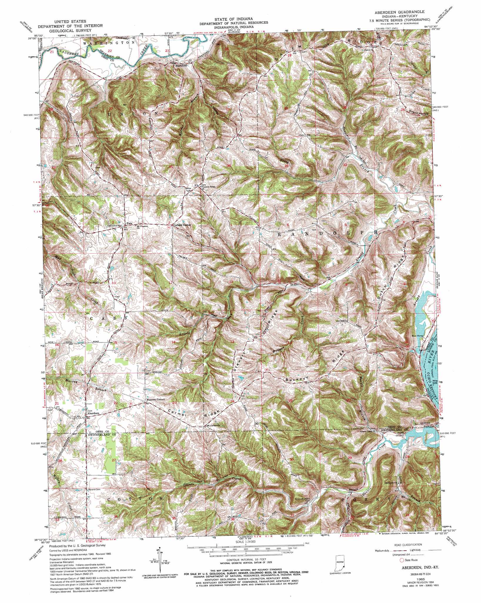
USGS Topo Quad 38084h8 - 1:24,000 scale
| Topo Map Name: | Aberdeen |
| USGS Topo Quad ID: | 38084h8 |
| Print Size: | ca. 21 1/4" wide x 27" high |
| Southeast Coordinates: | 38.875° N latitude / 84.875° W longitude |
| Map Center Coordinates: | 38.9375° N latitude / 84.9375° W longitude |
| U.S. States: | IN, KY |
| Filename: | o38084h8.jpg |
| Download Map JPG Image: | Aberdeen topo map 1:24,000 scale |
| Map Type: | Topographic |
| Topo Series: | 7.5´ |
| Map Scale: | 1:24,000 |
| Source of Map Images: | United States Geological Survey (USGS) |
| Alternate Map Versions: |
Aberdeen IN 1943 Download PDF Buy paper map Aberdeen IN 1953, updated 1955 Download PDF Buy paper map Aberdeen IN 1953, updated 1965 Download PDF Buy paper map Aberdeen IN 1965, updated 1967 Download PDF Buy paper map Aberdeen IN 1965, updated 1989 Download PDF Buy paper map Aberdeen IN 1965, updated 1994 Download PDF Buy paper map Aberdeen IN 2011 Download PDF Buy paper map Aberdeen IN 2013 Download PDF Buy paper map Aberdeen IN 2016 Download PDF Buy paper map |
1:24,000 Topo Quads surrounding Aberdeen
Pierceville |
Sunman |
Guilford |
Hooven |
Addyston |
Milan |
Dillsboro |
Aurora |
Lawrenceburg |
Burlington |
Cross Plains |
Bear Branch |
Aberdeen |
Rising Sun |
Union |
Bennington |
Vevay North |
Florence |
Patriot |
Verona |
Carrollton |
Vevay South |
Sanders |
Glencoe |
Elliston |
> Back to 38084e1 at 1:100,000 scale
> Back to 38084a1 at 1:250,000 scale
> Back to U.S. Topo Maps home
Aberdeen topo map: Gazetteer
Aberdeen: Populated Places
Aberdeen elevation 269m 882′Bascom Corner elevation 272m 892′
Cofield Corner elevation 269m 882′
Hartford elevation 153m 501′
Aberdeen: Ridges
Buckey Ridge elevation 260m 853′Carmel Ridge elevation 270m 885′
Dutch Ridge elevation 245m 803′
Salem Ridge elevation 275m 902′
Stewart Ridge elevation 262m 859′
Aberdeen: Streams
Arnold Creek elevation 137m 449′Henschen Branch elevation 148m 485′
Kinnet Branch elevation 138m 452′
Marble Branch elevation 140m 459′
North Branch Arnold Creek elevation 140m 459′
Wolfpen Creek elevation 151m 495′
Aberdeen digital topo map on disk
Buy this Aberdeen topo map showing relief, roads, GPS coordinates and other geographical features, as a high-resolution digital map file on DVD: