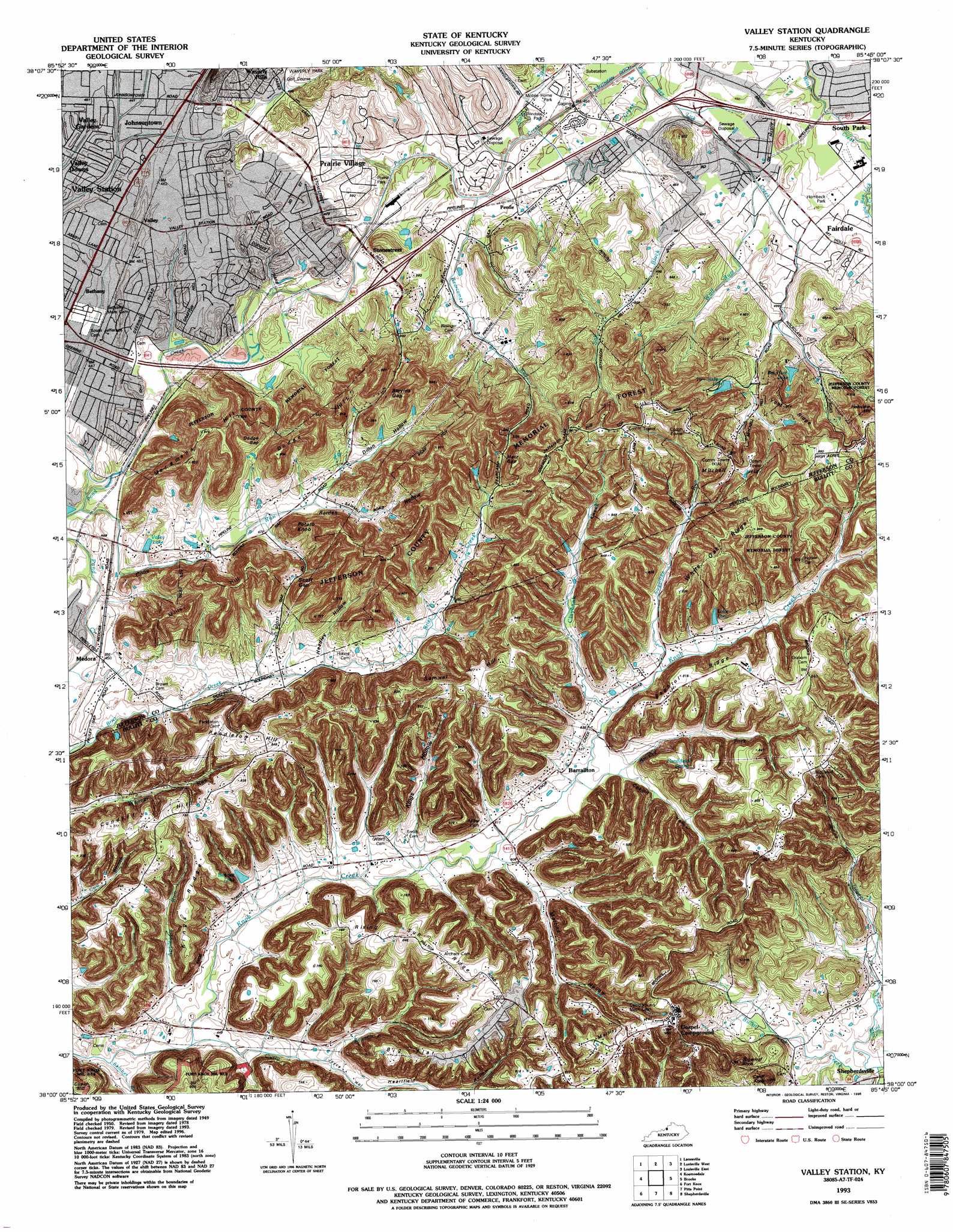
Valley Station Topo Map Kentucky
To zoom in, hover over the map of Valley Station
USGS Topo Quad 38085a7 - 1:24,000 scale
| Topo Map Name: | Valley Station |
| USGS Topo Quad ID: | 38085a7 |
| Print Size: | ca. 21 1/4" wide x 27" high |
| Southeast Coordinates: | 38° N latitude / 85.75° W longitude |
| Map Center Coordinates: | 38.0625° N latitude / 85.8125° W longitude |
| U.S. State: | KY |
| Filename: | o38085a7.jpg |
| Download Map JPG Image: | Valley Station topo map 1:24,000 scale |
| Map Type: | Topographic |
| Topo Series: | 7.5´ |
| Map Scale: | 1:24,000 |
| Source of Map Images: | United States Geological Survey (USGS) |
| Alternate Map Versions: |
Valley Station KY 1951 Download PDF Buy paper map Valley Station KY 1955, updated 1956 Download PDF Buy paper map Valley Station KY 1960, updated 1960 Download PDF Buy paper map Valley Station KY 1960, updated 1972 Download PDF Buy paper map Valley Station KY 1982, updated 1982 Download PDF Buy paper map Valley Station KY 1982, updated 1984 Download PDF Buy paper map Valley Station KY 1982, updated 1988 Download PDF Buy paper map Valley Station KY 1982, updated 1991 Download PDF Buy paper map Valley Station KY 1993, updated 1996 Download PDF Buy paper map Valley Station KY 2010 Download PDF Buy paper map Valley Station KY 2013 Download PDF Buy paper map Valley Station KY 2016 Download PDF Buy paper map |
1:24,000 Topo Quads surrounding Valley Station
Crandall |
Georgetown |
New Albany |
Jeffersonville |
Anchorage |
Corydon East |
Lanesville |
Louisville West |
Louisville East |
Jeffersontown |
Laconia |
Kosmosdale |
Valley Station |
Brooks |
Mount Washington |
Rock Haven |
Fort Knox |
Pitts Point |
Shepherdsville |
Samuels |
Flaherty |
Vine Grove |
Colesburg |
Lebanon Junction |
Cravens |
> Back to 38085a1 at 1:100,000 scale
> Back to 38084a1 at 1:250,000 scale
> Back to U.S. Topo Maps home
Valley Station topo map: Gazetteer
Valley Station: Airports
Humana Hospital Southwest Heliport elevation 143m 469′Valley Station: Flats
Big Flat elevation 234m 767′Valley Station: Forests
Jefferson County Memorial Forest elevation 258m 846′Valley Station: Gaps
Blevins Gap elevation 207m 679′Dodge Gap elevation 164m 538′
Metz Gap elevation 216m 708′
Scott Gap elevation 181m 593′
Valley Station: Parks
Gospel Campground elevation 258m 846′Valley Station: Populated Places
Barrallton elevation 162m 531′Bethany elevation 138m 452′
Fairdale elevation 145m 475′
Johnsontown elevation 138m 452′
Medora elevation 136m 446′
Penile elevation 139m 456′
Prairie Village elevation 144m 472′
Valley elevation 139m 456′
Valley Downs elevation 137m 449′
Valley Gardens elevation 137m 449′
Valley Station elevation 136m 446′
Waverly Hills elevation 148m 485′
Valley Station: Post Offices
Valley Station Post Office elevation 139m 456′Valley Station: Reservoirs
Bennett Lake elevation 156m 511′Big Horn Lake elevation 178m 583′
Elmo Lake elevation 182m 597′
Rieber Lake elevation 137m 449′
Tom Wallace Lake elevation 171m 561′
Valley Station: Ridges
Beghto Ridge elevation 205m 672′Kings Ridge elevation 215m 705′
White Oak Ridge elevation 261m 856′
Valley Station: Springs
Harshfield Spring elevation 230m 754′Valley Station: Streams
Applegate Run elevation 134m 439′Bearcamp Run elevation 133m 436′
Bee Lick Creek elevation 139m 456′
Brushy Fork elevation 155m 508′
Claybank Creek elevation 164m 538′
Crane Run elevation 128m 419′
Curry Branch elevation 133m 436′
Gravel Creek elevation 130m 426′
Mud Run elevation 128m 419′
Salt Block Creek elevation 134m 439′
Skinner Branch elevation 131m 429′
Slate Run elevation 132m 433′
Sugartree Run elevation 165m 541′
Valley Station: Summits
Cahill Knob elevation 230m 754′Cundiff Hill elevation 234m 767′
Dodge Hill elevation 245m 803′
Jefferson Hill elevation 261m 856′
Martins Hill elevation 256m 839′
Miller Hill elevation 237m 777′
Mitchell Hill elevation 261m 856′
Moremans Hill elevation 247m 810′
Pendleton Hill elevation 260m 853′
Potato Knob elevation 227m 744′
Samuel Hill elevation 255m 836′
Sugarloaf Knob elevation 230m 754′
Valley Station: Valleys
Coalpit Hollow elevation 160m 524′Dillon Hollow elevation 154m 505′
Headley Hollow elevation 146m 479′
Heartfield Hollow elevation 222m 728′
Joyce Hollow elevation 145m 475′
Kings Hollow elevation 159m 521′
Martins Hollow elevation 150m 492′
Rearden Hollow elevation 146m 479′
Valley Station digital topo map on disk
Buy this Valley Station topo map showing relief, roads, GPS coordinates and other geographical features, as a high-resolution digital map file on DVD: