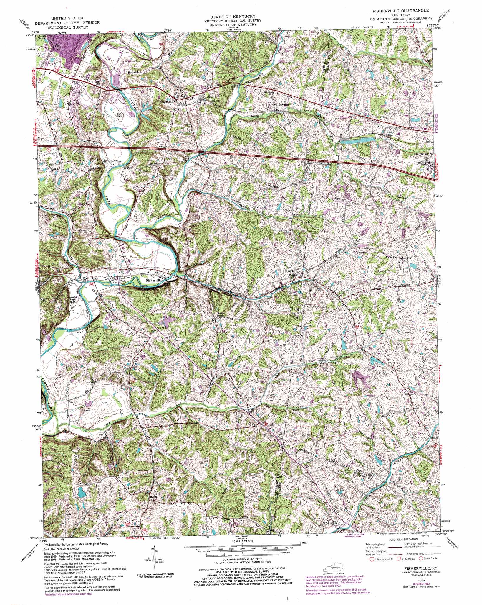
Fisherville Topo Map Kentucky
To zoom in, hover over the map of Fisherville
USGS Topo Quad 38085b4 - 1:24,000 scale
| Topo Map Name: | Fisherville |
| USGS Topo Quad ID: | 38085b4 |
| Print Size: | ca. 21 1/4" wide x 27" high |
| Southeast Coordinates: | 38.125° N latitude / 85.375° W longitude |
| Map Center Coordinates: | 38.1875° N latitude / 85.4375° W longitude |
| U.S. State: | KY |
| Filename: | o38085b4.jpg |
| Download Map JPG Image: | Fisherville topo map 1:24,000 scale |
| Map Type: | Topographic |
| Topo Series: | 7.5´ |
| Map Scale: | 1:24,000 |
| Source of Map Images: | United States Geological Survey (USGS) |
| Alternate Map Versions: |
Fisherville KY 1951 Download PDF Buy paper map Fisherville KY 1960, updated 1961 Download PDF Buy paper map Fisherville KY 1982, updated 1982 Download PDF Buy paper map Fisherville KY 1982, updated 1987 Download PDF Buy paper map Fisherville KY 1982, updated 1994 Download PDF Buy paper map Fisherville KY 2010 Download PDF Buy paper map Fisherville KY 2013 Download PDF Buy paper map Fisherville KY 2016 Download PDF Buy paper map |
1:24,000 Topo Quads surrounding Fisherville
Charlestown |
Owen |
La Grange |
Smithfield |
New Castle |
Jeffersonville |
Anchorage |
Crestwood |
Ballardsville |
Eminence |
Louisville East |
Jeffersontown |
Fisherville |
Simpsonville |
Shelbyville |
Brooks |
Mount Washington |
Waterford |
Taylorsville |
Mount Eden |
Shepherdsville |
Samuels |
Fairfield |
Bloomfield |
Chaplin |
> Back to 38085a1 at 1:100,000 scale
> Back to 38084a1 at 1:250,000 scale
> Back to U.S. Topo Maps home
Fisherville topo map: Gazetteer
Fisherville: Parks
Brentlawn Race Course (historical) elevation 196m 643′Fisherville: Populated Places
Boston elevation 187m 613′Conner elevation 215m 705′
Eastwood elevation 220m 721′
Fisherville elevation 170m 557′
L S Park elevation 228m 748′
Lincoln Ridge elevation 229m 751′
Long Run elevation 195m 639′
Routt elevation 204m 669′
Wilsonville elevation 196m 643′
Fisherville: Post Offices
Fisherville Post Office elevation 168m 551′Floyds Fork Post Office (historical) elevation 199m 652′
Lincoln Ridge Post Office (historical) elevation 233m 764′
Wilsonville Post Office (historical) elevation 195m 639′
Fisherville: Streams
Big Long Run elevation 208m 682′Brush Run elevation 168m 551′
Brush Run elevation 180m 590′
Cane Run elevation 158m 518′
Chenoweth Run elevation 180m 590′
Dunbar Branch elevation 176m 577′
East Fork Cane Run elevation 184m 603′
Long Run elevation 171m 561′
Pope Lick elevation 166m 544′
Shakes Run elevation 177m 580′
Sheckels Run elevation 166m 544′
South Long Run elevation 184m 603′
Fisherville digital topo map on disk
Buy this Fisherville topo map showing relief, roads, GPS coordinates and other geographical features, as a high-resolution digital map file on DVD: