Bethlehem Topo Map Indiana
To zoom in, hover over the map of Bethlehem
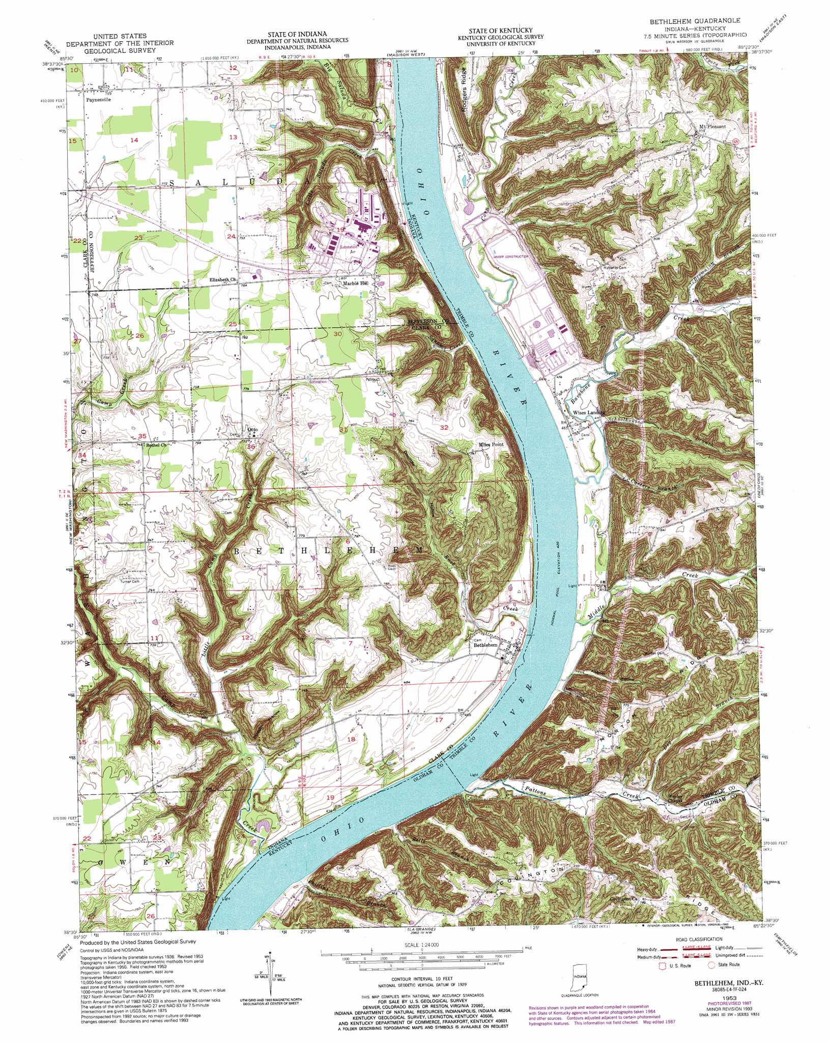
USGS Topo Quad 38085e4 - 1:24,000 scale
| Topo Map Name: | Bethlehem |
| USGS Topo Quad ID: | 38085e4 |
| Print Size: | ca. 21 1/4" wide x 27" high |
| Southeast Coordinates: | 38.5° N latitude / 85.375° W longitude |
| Map Center Coordinates: | 38.5625° N latitude / 85.4375° W longitude |
| U.S. States: | IN, KY |
| Filename: | o38085e4.jpg |
| Download Map JPG Image: | Bethlehem topo map 1:24,000 scale |
| Map Type: | Topographic |
| Topo Series: | 7.5´ |
| Map Scale: | 1:24,000 |
| Source of Map Images: | United States Geological Survey (USGS) |
| Alternate Map Versions: |
Bethlehem IN 1939 Download PDF Buy paper map Bethlehem IN 1939 Download PDF Buy paper map Bethlehem IN 1948 Download PDF Buy paper map Bethlehem IN 1953, updated 1955 Download PDF Buy paper map Bethlehem IN 1953, updated 1957 Download PDF Buy paper map Bethlehem IN 1953, updated 1972 Download PDF Buy paper map Bethlehem IN 1953, updated 1981 Download PDF Buy paper map Bethlehem IN 1953, updated 1987 Download PDF Buy paper map Bethlehem IN 1953, updated 1993 Download PDF Buy paper map Bethlehem IN 2010 Download PDF Buy paper map Bethlehem IN 2013 Download PDF Buy paper map Bethlehem IN 2016 Download PDF Buy paper map |
1:24,000 Topo Quads surrounding Bethlehem
Deputy |
Volga |
Clifty Falls |
Canaan |
Bennington |
Blocher |
Kent |
Madison West |
Madison East |
Carrollton |
Otisco |
New Washington |
Bethlehem |
Bedford |
Campbellsburg |
Charlestown |
Owen |
La Grange |
Smithfield |
New Castle |
Jeffersonville |
Anchorage |
Crestwood |
Ballardsville |
Eminence |
> Back to 38085e1 at 1:100,000 scale
> Back to 38084a1 at 1:250,000 scale
> Back to U.S. Topo Maps home
Bethlehem topo map: Gazetteer
Bethlehem: Populated Places
Bethlehem elevation 143m 469′Marble Hill elevation 244m 800′
Miles Point elevation 243m 797′
Mount Pleasant elevation 259m 849′
Otto elevation 231m 757′
Paynesville elevation 233m 764′
Wises Landing elevation 138m 452′
Bethlehem: Ridges
Covington Ridge elevation 204m 669′Bethlehem: Streams
Barebone Creek elevation 129m 423′Bells Branch elevation 130m 426′
Big Saluda Creek elevation 128m 419′
Browning Branch elevation 142m 465′
Carters Branch elevation 132m 433′
Corn Creek elevation 128m 419′
Dog Branch elevation 140m 459′
Jeff Branch elevation 155m 508′
Knob Creek elevation 128m 419′
Little Camp Creek elevation 131m 429′
Little Saluda Creek elevation 128m 419′
Middle Creek elevation 128m 419′
Pattons Creek elevation 128m 419′
Phillips Branch elevation 131m 429′
Schoolhouse Branch elevation 134m 439′
Squaw Creek elevation 128m 419′
Bethlehem: Valleys
Abbott Hollow elevation 135m 442′Dodson Hollow elevation 136m 446′
Doolittle Hollow elevation 161m 528′
Bethlehem digital topo map on disk
Buy this Bethlehem topo map showing relief, roads, GPS coordinates and other geographical features, as a high-resolution digital map file on DVD: