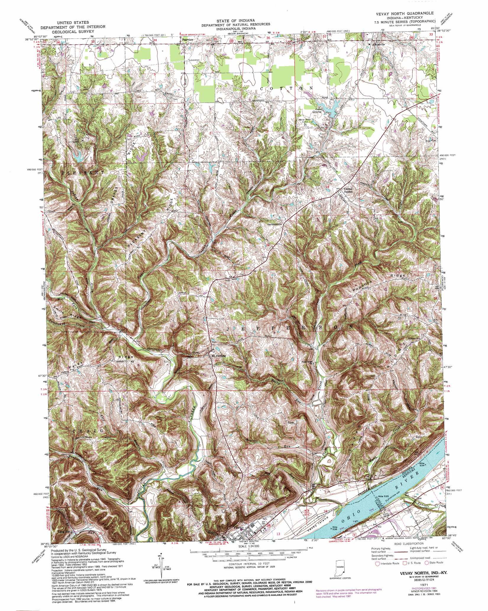
Vevay North Topo Map Indiana
To zoom in, hover over the map of Vevay North
USGS Topo Quad 38085g1 - 1:24,000 scale
| Topo Map Name: | Vevay North |
| USGS Topo Quad ID: | 38085g1 |
| Print Size: | ca. 21 1/4" wide x 27" high |
| Southeast Coordinates: | 38.75° N latitude / 85° W longitude |
| Map Center Coordinates: | 38.8125° N latitude / 85.0625° W longitude |
| U.S. States: | IN, KY |
| Filename: | o38085g1.jpg |
| Download Map JPG Image: | Vevay North topo map 1:24,000 scale |
| Map Type: | Topographic |
| Topo Series: | 7.5´ |
| Map Scale: | 1:24,000 |
| Source of Map Images: | United States Geological Survey (USGS) |
| Alternate Map Versions: |
Vevay North IN 1943 Download PDF Buy paper map Vevay North IN 1957, updated 1958 Download PDF Buy paper map Vevay North IN 1957, updated 1958 Download PDF Buy paper map Vevay North IN 1971, updated 1973 Download PDF Buy paper map Vevay North IN 1971, updated 1981 Download PDF Buy paper map Vevay North IN 1971, updated 1994 Download PDF Buy paper map Vevay North IN 2010 Download PDF Buy paper map Vevay North IN 2013 Download PDF Buy paper map Vevay North IN 2016 Download PDF Buy paper map |
1:24,000 Topo Quads surrounding Vevay North
Versailles |
Milan |
Dillsboro |
Aurora |
Lawrenceburg |
Rexville |
Cross Plains |
Bear Branch |
Aberdeen |
Rising Sun |
Canaan |
Bennington |
Vevay North |
Florence |
Patriot |
Madison East |
Carrollton |
Vevay South |
Sanders |
Glencoe |
Bedford |
Campbellsburg |
Worthville |
New Liberty |
Owenton |
> Back to 38085e1 at 1:100,000 scale
> Back to 38084a1 at 1:250,000 scale
> Back to U.S. Topo Maps home
Vevay North topo map: Gazetteer
Vevay North: Dams
Camp Livingston Lake Dam elevation 238m 780′Edwin Pray Lake Dam elevation 248m 813′
Lake Geneva Dam elevation 252m 826′
Vevay North: Islands
Vevay Island elevation 134m 439′Vevay North: Parks
Camp Livingston elevation 256m 839′White Water Camp elevation 266m 872′
Vevay North: Populated Places
Allensville elevation 267m 875′Center Square elevation 270m 885′
Fairview elevation 272m 892′
Jacksonville elevation 263m 862′
Long Run elevation 144m 472′
Mount Sterling elevation 242m 793′
Vevay North: Reservoirs
Camp Livingston Lake elevation 238m 780′Edwin Pray Lake elevation 248m 813′
Lake Geneva elevation 260m 853′
Vevay North: Ridges
Drakes Ridge elevation 263m 862′Parks Ridge elevation 228m 748′
Pleasant Ridge elevation 257m 843′
Popcorn Ridge elevation 254m 833′
Tapps Ridge elevation 254m 833′
Vevay North: Streams
Abes Branch elevation 134m 439′Agniels Creek elevation 131m 429′
Beetree Run elevation 134m 439′
Broad Run elevation 137m 449′
Halls Branch elevation 144m 472′
Hog Run elevation 134m 439′
Hunt Creek elevation 130m 426′
Long Run elevation 131m 429′
Pendleton Run elevation 132m 433′
Plum Creek elevation 134m 439′
Tumblebug Creek elevation 159m 521′
Upper Indian Creek elevation 155m 508′
West Fork Indian Creek elevation 161m 528′
Vevay North digital topo map on disk
Buy this Vevay North topo map showing relief, roads, GPS coordinates and other geographical features, as a high-resolution digital map file on DVD: