Vernon Topo Map Indiana
To zoom in, hover over the map of Vernon
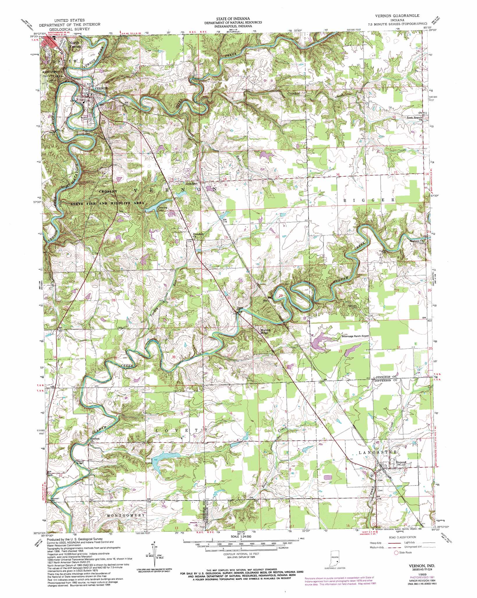
USGS Topo Quad 38085h5 - 1:24,000 scale
| Topo Map Name: | Vernon |
| USGS Topo Quad ID: | 38085h5 |
| Print Size: | ca. 21 1/4" wide x 27" high |
| Southeast Coordinates: | 38.875° N latitude / 85.5° W longitude |
| Map Center Coordinates: | 38.9375° N latitude / 85.5625° W longitude |
| U.S. State: | IN |
| Filename: | o38085h5.jpg |
| Download Map JPG Image: | Vernon topo map 1:24,000 scale |
| Map Type: | Topographic |
| Topo Series: | 7.5´ |
| Map Scale: | 1:24,000 |
| Source of Map Images: | United States Geological Survey (USGS) |
| Alternate Map Versions: |
Vernon IN 1959, updated 1960 Download PDF Buy paper map Vernon IN 1959, updated 1973 Download PDF Buy paper map Vernon IN 1959, updated 1981 Download PDF Buy paper map Vernon IN 1959, updated 1994 Download PDF Buy paper map Vernon IN 1959, updated 1994 Download PDF Buy paper map Vernon IN 2010 Download PDF Buy paper map Vernon IN 2013 Download PDF Buy paper map Vernon IN 2016 Download PDF Buy paper map |
1:24,000 Topo Quads surrounding Vernon
Elizabethtown |
Grammer |
Westport |
Millhousen |
Osgood |
Azalia |
North Vernon |
Butlerville |
Holton |
Versailles |
Chestnut Ridge |
Hayden |
Vernon |
San Jacinto |
Rexville |
Crothersville |
Deputy |
Volga |
Clifty Falls |
Canaan |
Scottsburg |
Blocher |
Kent |
Madison West |
Madison East |
> Back to 38085e1 at 1:100,000 scale
> Back to 38084a1 at 1:250,000 scale
> Back to U.S. Topo Maps home
Vernon topo map: Gazetteer
Vernon: Airports
Broomsage Ranch Airport elevation 247m 810′Vernon: Dams
Broomsage Ranch Lake Dam elevation 239m 784′Crosley Lake Dam elevation 223m 731′
Gaylord Stark Lake Dam elevation 233m 764′
Hickory Lake Dam elevation 213m 698′
Whippoorwill Lake Dam elevation 214m 702′
Vernon: Parks
Crosley State Fish and Wildlife Area elevation 216m 708′Vernon: Populated Places
Dupont elevation 241m 790′Grayford elevation 230m 754′
Vernon elevation 202m 662′
Walnut Ridge elevation 235m 770′
Vernon: Reservoirs
Broomsage Lake elevation 239m 784′Crosley Lake elevation 215m 705′
Gaylord Stark Lake elevation 233m 764′
Hickory Lake elevation 213m 698′
Whippoorwill Lake elevation 214m 702′
Vernon: Streams
Camp Creek elevation 231m 757′Crooked Creek elevation 194m 636′
Goose Run elevation 191m 626′
Huckleberry Branch elevation 205m 672′
Otter Creek elevation 184m 603′
Turkey Run elevation 203m 666′
Vernon digital topo map on disk
Buy this Vernon topo map showing relief, roads, GPS coordinates and other geographical features, as a high-resolution digital map file on DVD: