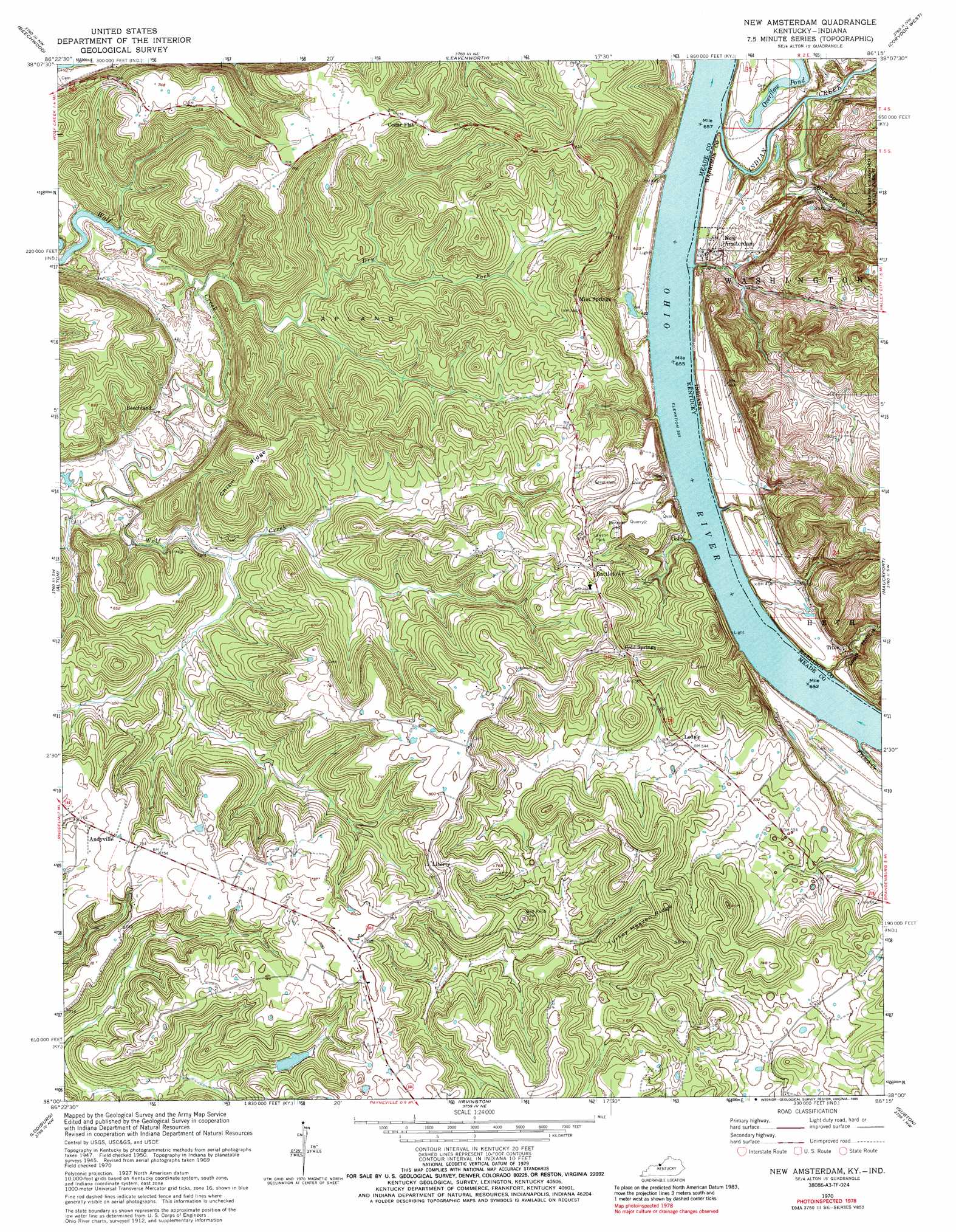
New Amsterdam Topo Map Kentucky
To zoom in, hover over the map of New Amsterdam
USGS Topo Quad 38086a3 - 1:24,000 scale
| Topo Map Name: | New Amsterdam |
| USGS Topo Quad ID: | 38086a3 |
| Print Size: | ca. 21 1/4" wide x 27" high |
| Southeast Coordinates: | 38° N latitude / 86.25° W longitude |
| Map Center Coordinates: | 38.0625° N latitude / 86.3125° W longitude |
| U.S. States: | KY, IN |
| Filename: | o38086a3.jpg |
| Download Map JPG Image: | New Amsterdam topo map 1:24,000 scale |
| Map Type: | Topographic |
| Topo Series: | 7.5´ |
| Map Scale: | 1:24,000 |
| Source of Map Images: | United States Geological Survey (USGS) |
| Alternate Map Versions: |
New Amsterdam IN 1950, updated 1954 Download PDF Buy paper map New Amsterdam IN 1950, updated 1967 Download PDF Buy paper map New Amsterdam IN 1970, updated 1972 Download PDF Buy paper map New Amsterdam IN 1970, updated 1989 Download PDF Buy paper map New Amsterdam IN 2010 Download PDF Buy paper map New Amsterdam IN 2013 Download PDF Buy paper map New Amsterdam IN 2016 Download PDF Buy paper map |
1:24,000 Topo Quads surrounding New Amsterdam
Taswell |
English |
Milltown |
Depauw |
Crandall |
Branchville |
Beechwood |
Leavenworth |
Corydon West |
Corydon East |
Derby |
Alton |
New Amsterdam |
Mauckport |
Laconia |
Rome |
Lodiburg |
Irvington |
Guston |
Rock Haven |
Mattingly |
Hardinsburg |
Garfield |
Big Spring |
Flaherty |
> Back to 38086a1 at 1:100,000 scale
> Back to 38086a1 at 1:250,000 scale
> Back to U.S. Topo Maps home
New Amsterdam topo map: Gazetteer
New Amsterdam: Areas
Lapland elevation 177m 580′New Amsterdam: Lakes
Overflow Pond elevation 123m 403′New Amsterdam: Parks
Lawson Park elevation 208m 682′New Amsterdam: Populated Places
Andyville elevation 216m 708′Battletown elevation 212m 695′
Beechland elevation 132m 433′
Cedar Flat elevation 242m 793′
Cold Springs elevation 229m 751′
Liberty elevation 244m 800′
Lodale elevation 172m 564′
New Amsterdam elevation 137m 449′
Oolite elevation 136m 446′
Titus elevation 130m 426′
New Amsterdam: Ridges
Chism Ridge elevation 241m 790′Turkey Heaven Ridge elevation 228m 748′
New Amsterdam: Springs
Big Spring elevation 127m 416′New Amsterdam: Streams
Brock Creek elevation 243m 797′Dry Fork elevation 118m 387′
French Creek elevation 116m 380′
Indian Creek elevation 116m 380′
New Amsterdam: Valleys
Blue Spring Hollow elevation 122m 400′Gas Well Hollow elevation 126m 413′
Lopp Hollow elevation 123m 403′
New Amsterdam digital topo map on disk
Buy this New Amsterdam topo map showing relief, roads, GPS coordinates and other geographical features, as a high-resolution digital map file on DVD: