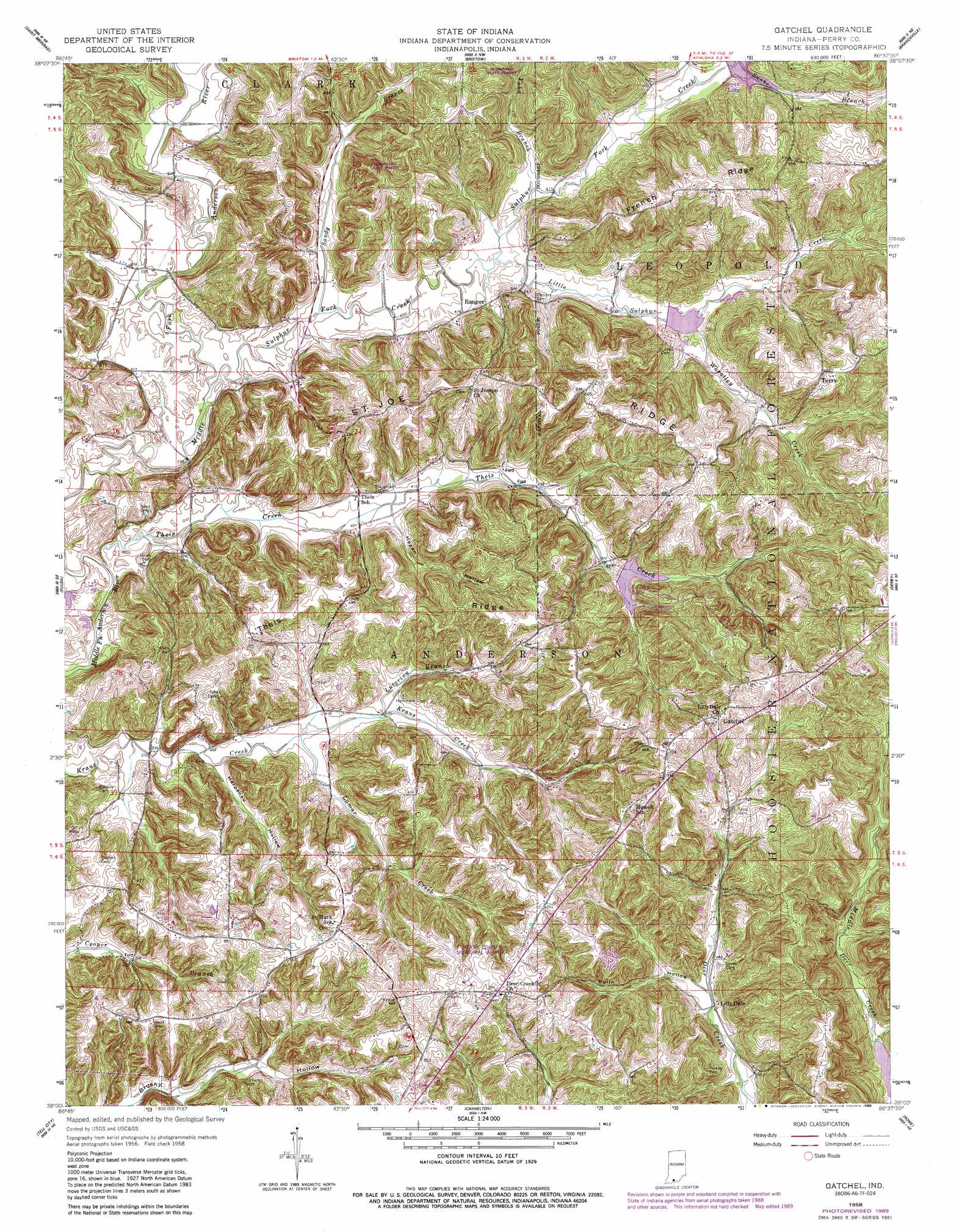
Gatchel Topo Map Indiana
To zoom in, hover over the map of Gatchel
USGS Topo Quad 38086a6 - 1:24,000 scale
| Topo Map Name: | Gatchel |
| USGS Topo Quad ID: | 38086a6 |
| Print Size: | ca. 21 1/4" wide x 27" high |
| Southeast Coordinates: | 38° N latitude / 86.625° W longitude |
| Map Center Coordinates: | 38.0625° N latitude / 86.6875° W longitude |
| U.S. State: | IN |
| Filename: | o38086a6.jpg |
| Download Map JPG Image: | Gatchel topo map 1:24,000 scale |
| Map Type: | Topographic |
| Topo Series: | 7.5´ |
| Map Scale: | 1:24,000 |
| Source of Map Images: | United States Geological Survey (USGS) |
| Alternate Map Versions: |
Gatchel IN 1958, updated 1959 Download PDF Buy paper map Gatchel IN 1958, updated 1977 Download PDF Buy paper map Gatchel IN 1958, updated 1981 Download PDF Buy paper map Gatchel IN 1958, updated 1989 Download PDF Buy paper map Gatchel IN 1993, updated 1996 Download PDF Buy paper map Gatchel IN 2010 Download PDF Buy paper map Gatchel IN 2013 Download PDF Buy paper map Gatchel IN 2016 Download PDF Buy paper map |
| FStopo: | US Forest Service topo Gatchel is available: Download FStopo PDF Download FStopo TIF |
1:24,000 Topo Quads surrounding Gatchel
Huntingburg |
Saint Anthony |
Birdseye |
Taswell |
English |
Dale |
Saint Meinrad |
Bristow |
Branchville |
Beechwood |
Santa Claus |
Fulda |
Gatchel |
Derby |
Alton |
Lewisport |
Tell City |
Cannelton |
Rome |
Lodiburg |
Maceo |
Pellville |
Cloverport |
Mattingly |
Hardinsburg |
> Back to 38086a1 at 1:100,000 scale
> Back to 38086a1 at 1:250,000 scale
> Back to U.S. Topo Maps home
Gatchel topo map: Gazetteer
Gatchel: Airports
Perry County Municipal Airport elevation 196m 643′Gatchel: Dams
Middle Fork Dam Number 1 elevation 150m 492′Middle Fork Dam Number 2 elevation 129m 423′
Gatchel: Lakes
Gatchel Pond elevation 199m 652′Middle Deer Pond elevation 199m 652′
Gatchel: Parks
Saddle Lake Recreation Area elevation 144m 472′Gatchel: Populated Places
Gatchel elevation 218m 715′Lilly Dale elevation 138m 452′
Ranger elevation 131m 429′
Terry elevation 208m 682′
Gatchel: Post Offices
Don Juan Post Office (historical) elevation 128m 419′Gatchel: Reservoirs
Mill Lake elevation 129m 423′Saddle Lake elevation 150m 492′
Tipsaw Lake elevation 133m 436′
Gatchel: Ridges
French Ridge elevation 202m 662′Saint Joe Ridge elevation 209m 685′
Saint Joe Ridge elevation 191m 626′
Theis Ridge elevation 180m 590′
Gatchel: Streams
Lamar Creek elevation 125m 410′Little Sulphur Creek elevation 125m 410′
Lutgring Branch elevation 128m 419′
Sandy Branch elevation 122m 400′
Sulphur Fork Creek elevation 119m 390′
Theis Creek elevation 115m 377′
Wheatley Creek elevation 129m 423′
Yoho Branch elevation 125m 410′
Gatchel: Valleys
Bolin Hollow elevation 138m 452′Harpenau Hollow elevation 122m 400′
Hogan Hollow elevation 128m 419′
Gatchel digital topo map on disk
Buy this Gatchel topo map showing relief, roads, GPS coordinates and other geographical features, as a high-resolution digital map file on DVD: