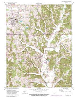
Saint Meinrad Topo Map Indiana
To zoom in, hover over the map of Saint Meinrad
USGS Topo Quad 38086b7 - 1:24,000 scale
| Topo Map Name: | Saint Meinrad |
| USGS Topo Quad ID: | 38086b7 |
| Print Size: | ca. 21 1/4" wide x 27" high |
| Southeast Coordinates: | 38.125° N latitude / 86.75° W longitude |
| Map Center Coordinates: | 38.1875° N latitude / 86.8125° W longitude |
| U.S. State: | IN |
| Filename: | o38086b7.jpg |
| Download Map JPG Image: | Saint Meinrad topo map 1:24,000 scale |
| Map Type: | Topographic |
| Topo Series: | 7.5´ |
| Map Scale: | 1:24,000 |
| Source of Map Images: | United States Geological Survey (USGS) |
| Alternate Map Versions: |
Saint Meinrad IN 1960, updated 1962 Download PDF Buy paper map Saint Meinrad IN 1960, updated 1962 Download PDF Buy paper map Saint Meinrad IN 1960, updated 1981 Download PDF Buy paper map Saint Meinrad IN 1960, updated 1981 Download PDF Buy paper map Saint Meinrad IN 2010 Download PDF Buy paper map Saint Meinrad IN 2013 Download PDF Buy paper map Saint Meinrad IN 2016 Download PDF Buy paper map |
1:24,000 Topo Quads surrounding Saint Meinrad
> Back to 38086a1 at 1:100,000 scale
> Back to 38086a1 at 1:250,000 scale
> Back to U.S. Topo Maps home
Saint Meinrad topo map: Gazetteer
Saint Meinrad: Canals
Monkey Hollow Ditch elevation 125m 410′Saint Meinrad: Crossings
Interchange 63 elevation 162m 531′Saint Meinrad: Dams
Felmont Oil Company Dam elevation 152m 498′Ferdinand Old Lake Dam elevation 164m 538′
Ferdinand Water Supply Reservoir Dam elevation 151m 495′
Saint Meinrad: Forests
Ferdinand State Forest elevation 198m 649′Saint Meinrad: Lakes
Saint Meinrad Lake elevation 166m 544′Saint Meinrad: Populated Places
Adyeville elevation 129m 423′Ferdinand elevation 164m 538′
Monte Cassino Shrine elevation 185m 606′
Saint Josephs Shrine elevation 134m 439′
Saint Meinrad elevation 135m 442′
Saint Meinrad: Reservoirs
Felmont Oil Company Reservoir elevation 152m 498′Ferdinand Old Lake elevation 164m 538′
Ferdinand Water Supply Reservoir elevation 151m 495′
Holiday Lake elevation 159m 521′
Saint Meinrad: Streams
Abbey Run elevation 125m 410′Bird Run elevation 130m 426′
Black Run elevation 134m 439′
Blackhawk Creek elevation 125m 410′
Crooks Hollow Creek elevation 126m 413′
Cyclone Branch elevation 129m 423′
Ferdinand Run elevation 125m 410′
Friday Branch elevation 128m 419′
Hawk Run elevation 131m 429′
Hurricane Creek elevation 125m 410′
Monte Run elevation 126m 413′
Nest Run elevation 130m 426′
Pale Run elevation 146m 479′
Rock Run elevation 127m 416′
Rockhouse Branch elevation 125m 410′
Stapleton Run elevation 128m 419′
Swinging Creek elevation 122m 400′
Till Drain elevation 122m 400′
Water Run elevation 149m 488′
Wind Run elevation 128m 419′
Saint Meinrad: Valleys
Meinrad Hollow elevation 122m 400′Saint Meinrad digital topo map on disk
Buy this Saint Meinrad topo map showing relief, roads, GPS coordinates and other geographical features, as a high-resolution digital map file on DVD:


