Owensburg Topo Map Indiana
To zoom in, hover over the map of Owensburg
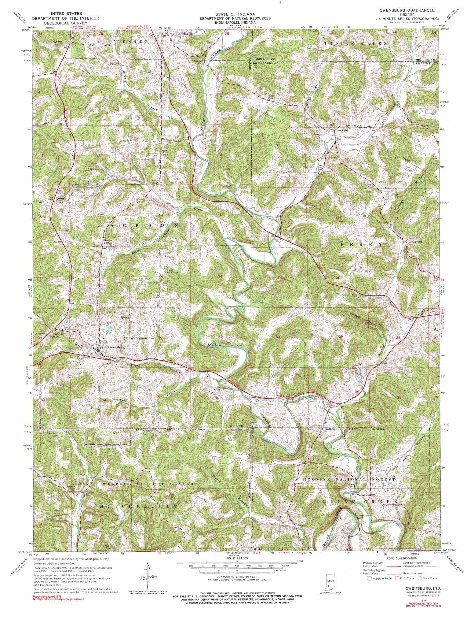
USGS Topo Quad 38086h6 - 1:24,000 scale
| Topo Map Name: | Owensburg |
| USGS Topo Quad ID: | 38086h6 |
| Print Size: | ca. 21 1/4" wide x 27" high |
| Southeast Coordinates: | 38.875° N latitude / 86.625° W longitude |
| Map Center Coordinates: | 38.9375° N latitude / 86.6875° W longitude |
| U.S. State: | IN |
| Filename: | o38086h6.jpg |
| Download Map JPG Image: | Owensburg topo map 1:24,000 scale |
| Map Type: | Topographic |
| Topo Series: | 7.5´ |
| Map Scale: | 1:24,000 |
| Source of Map Images: | United States Geological Survey (USGS) |
| Alternate Map Versions: |
Owensburg IN 1957, updated 1958 Download PDF Buy paper map Owensburg IN 1975, updated 1976 Download PDF Buy paper map Owensburg IN 1975, updated 1978 Download PDF Buy paper map Owensburg IN 2010 Download PDF Buy paper map Owensburg IN 2013 Download PDF Buy paper map Owensburg IN 2016 Download PDF Buy paper map |
| FStopo: | US Forest Service topo Owensburg is available: Download FStopo PDF Download FStopo TIF |
1:24,000 Topo Quads surrounding Owensburg
Arney |
Freedom |
Whitehall |
Bloomington |
Unionville |
Bloomfield |
Solsberry |
Stanford |
Clear Creek |
Allens Creek |
Scotland |
Koleen |
Owensburg |
Oolitic |
Bartlettsville |
Odon |
Indian Springs |
Williams |
Bedford West |
Bedford East |
Loogootee |
Shoals |
Huron |
Georgia |
Mitchell |
> Back to 38086e1 at 1:100,000 scale
> Back to 38086a1 at 1:250,000 scale
> Back to U.S. Topo Maps home
Owensburg topo map: Gazetteer
Owensburg: Dams
Thomas Lake Dam elevation 209m 685′Owensburg: Populated Places
Hobbieville elevation 239m 784′Owensburg elevation 196m 643′
Popcorn elevation 198m 649′
Owensburg: Reservoirs
Thomas Lake elevation 209m 685′Owensburg: Springs
Sexson Spring elevation 204m 669′Owensburg: Streams
Cole Branch elevation 167m 547′Dry Branch elevation 184m 603′
Hodge Branch elevation 192m 629′
Little Indian Creek elevation 177m 580′
Mitchell Branch elevation 183m 600′
Popcorn Creek elevation 181m 593′
Spring Creek elevation 169m 554′
Town Branch elevation 168m 551′
Owensburg: Summits
Tunnel Hill elevation 260m 853′Owensburg: Valleys
Boone Hollow elevation 164m 538′Hert Hollow elevation 184m 603′
Linden Hollow elevation 204m 669′
Speed Hollow elevation 182m 597′
Owensburg digital topo map on disk
Buy this Owensburg topo map showing relief, roads, GPS coordinates and other geographical features, as a high-resolution digital map file on DVD: