Sandborn Topo Map Indiana
To zoom in, hover over the map of Sandborn
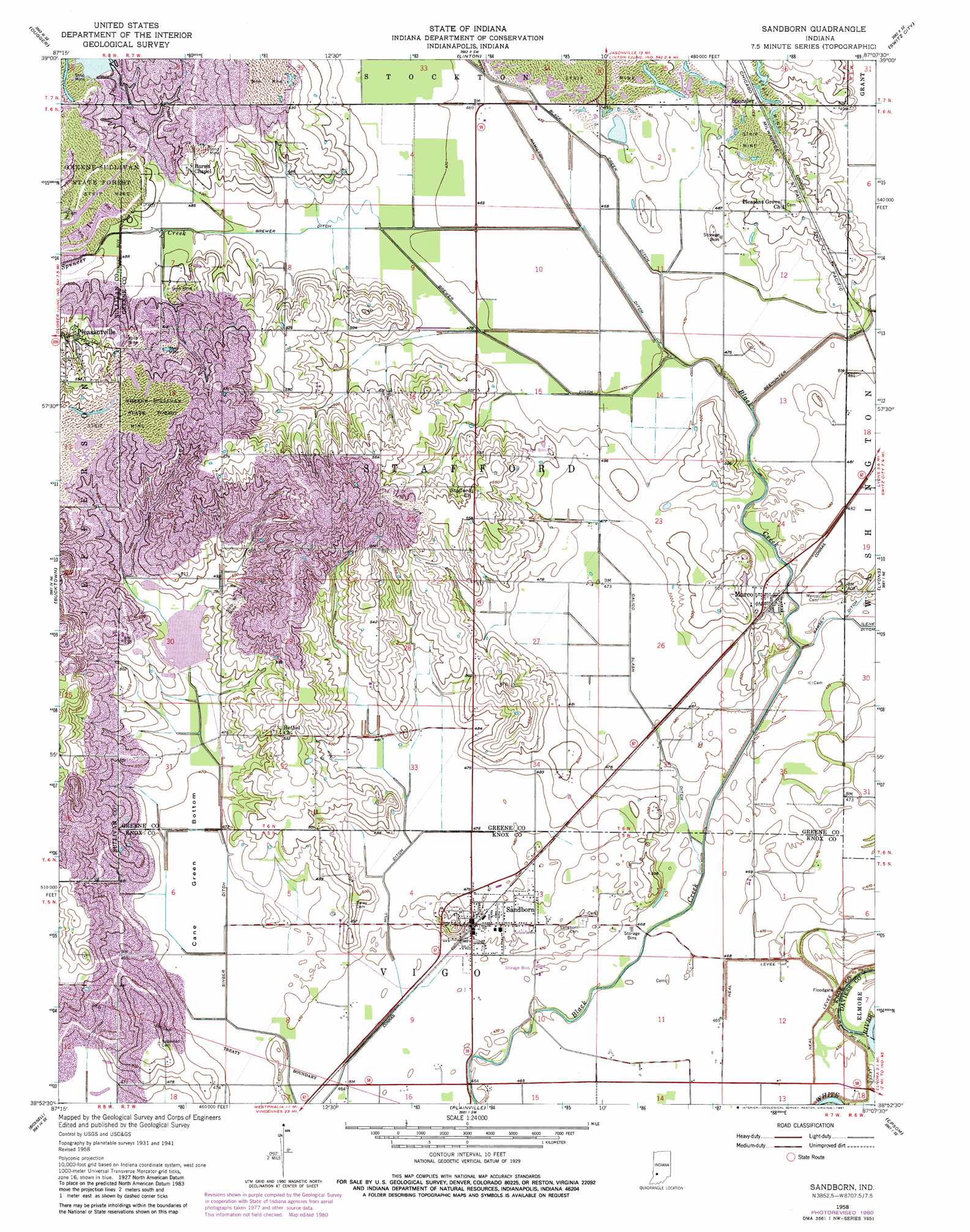
USGS Topo Quad 38087h2 - 1:24,000 scale
| Topo Map Name: | Sandborn |
| USGS Topo Quad ID: | 38087h2 |
| Print Size: | ca. 21 1/4" wide x 27" high |
| Southeast Coordinates: | 38.875° N latitude / 87.125° W longitude |
| Map Center Coordinates: | 38.9375° N latitude / 87.1875° W longitude |
| U.S. State: | IN |
| Filename: | o38087h2.jpg |
| Download Map JPG Image: | Sandborn topo map 1:24,000 scale |
| Map Type: | Topographic |
| Topo Series: | 7.5´ |
| Map Scale: | 1:24,000 |
| Source of Map Images: | United States Geological Survey (USGS) |
| Alternate Map Versions: |
Sandborn IN 1943 Download PDF Buy paper map Sandborn IN 1958, updated 1959 Download PDF Buy paper map Sandborn IN 1958, updated 1981 Download PDF Buy paper map Sandborn IN 2010 Download PDF Buy paper map Sandborn IN 2013 Download PDF Buy paper map Sandborn IN 2016 Download PDF Buy paper map |
1:24,000 Topo Quads surrounding Sandborn
Shelburn |
Hymera |
Jasonville |
Coal City |
Arney |
Sullivan |
Dugger |
Linton |
Switz City |
Bloomfield |
Carlisle |
Bucktown |
Sandborn |
Lyons |
Scotland |
Oaktown |
Bicknell |
Plainville |
Epsom |
Odon |
Fritchton |
Wheatland |
Washington |
Montgomery |
Loogootee |
> Back to 38087e1 at 1:100,000 scale
> Back to 38086a1 at 1:250,000 scale
> Back to U.S. Topo Maps home
Sandborn topo map: Gazetteer
Sandborn: Basins
Cane Green Bottom elevation 142m 465′Sandborn: Canals
Armuth Ditch elevation 143m 469′Black Creek Ditch elevation 143m 469′
Brewer Ditch elevation 143m 469′
Calico Slash Ditch elevation 143m 469′
Hamilton Ditch elevation 143m 469′
Hill Ditch elevation 143m 469′
Singer Ditch elevation 143m 469′
Sandborn: Dams
Singer Ditch Dam elevation 144m 472′Sandborn: Forests
Greene-Sullivan State Forest elevation 159m 521′Sandborn: Levees
McGinnis Levee elevation 141m 462′Neal Levee elevation 140m 459′
Sandborn: Populated Places
Marco elevation 148m 485′Sandborn elevation 146m 479′
Sandborn: Streams
Spencer Creek elevation 146m 479′Sandborn: Swamps
Goose Pond (historical) elevation 143m 469′Sandborn digital topo map on disk
Buy this Sandborn topo map showing relief, roads, GPS coordinates and other geographical features, as a high-resolution digital map file on DVD: