Stoy Topo Map Illinois
To zoom in, hover over the map of Stoy
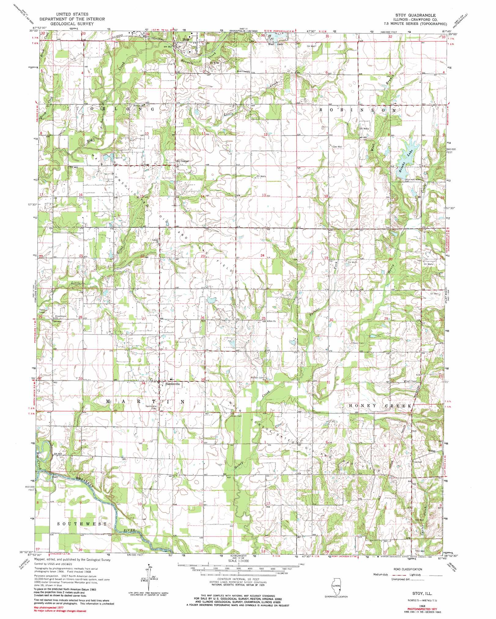
USGS Topo Quad 38087h7 - 1:24,000 scale
| Topo Map Name: | Stoy |
| USGS Topo Quad ID: | 38087h7 |
| Print Size: | ca. 21 1/4" wide x 27" high |
| Southeast Coordinates: | 38.875° N latitude / 87.75° W longitude |
| Map Center Coordinates: | 38.9375° N latitude / 87.8125° W longitude |
| U.S. State: | IL |
| Filename: | o38087h7.jpg |
| Download Map JPG Image: | Stoy topo map 1:24,000 scale |
| Map Type: | Topographic |
| Topo Series: | 7.5´ |
| Map Scale: | 1:24,000 |
| Source of Map Images: | United States Geological Survey (USGS) |
| Alternate Map Versions: |
Stoy IL 1968, updated 1970 Download PDF Buy paper map Stoy IL 1968, updated 1983 Download PDF Buy paper map Stoy IL 2012 Download PDF Buy paper map Stoy IL 2015 Download PDF Buy paper map |
1:24,000 Topo Quads surrounding Stoy
Hazel Dell |
Moriah |
Annapolis |
West Union |
Fairbanks |
Yale |
Oblong North |
Eaton |
Hutsonville |
Merom |
Sainte Marie |
Oblong South |
Stoy |
Flat Rock |
Heathsville |
Dundas |
Landes |
Chauncey |
Birds |
Russellville |
Olney |
Claremont |
Sumner |
Lawrenceville |
Vincennes |
> Back to 38087e1 at 1:100,000 scale
> Back to 38086a1 at 1:250,000 scale
> Back to U.S. Topo Maps home
Stoy topo map: Gazetteer
Stoy: Bridges
Spencer Bridge (historical) elevation 130m 426′Stoy: Dams
Brooks Lake Dam elevation 157m 515′Stoy: Oilfields
Main Consolidated Oil and Gas Field elevation 145m 475′Stoy: Populated Places
Hardinville elevation 155m 508′Oil Center elevation 151m 495′
Stoy elevation 147m 482′
Villas elevation 175m 574′
Stoy: Post Offices
Grand Glade Post Office (historical) elevation 146m 479′Stoy: Reservoirs
Brooks Lake elevation 157m 515′Stoy: Streams
Bennett Creek elevation 140m 459′Big Creek elevation 131m 429′
Painter Fork elevation 134m 439′
West Branch Honey Creek elevation 144m 472′
Stoy digital topo map on disk
Buy this Stoy topo map showing relief, roads, GPS coordinates and other geographical features, as a high-resolution digital map file on DVD: