Albion Nw Topo Map Illinois
To zoom in, hover over the map of Albion Nw
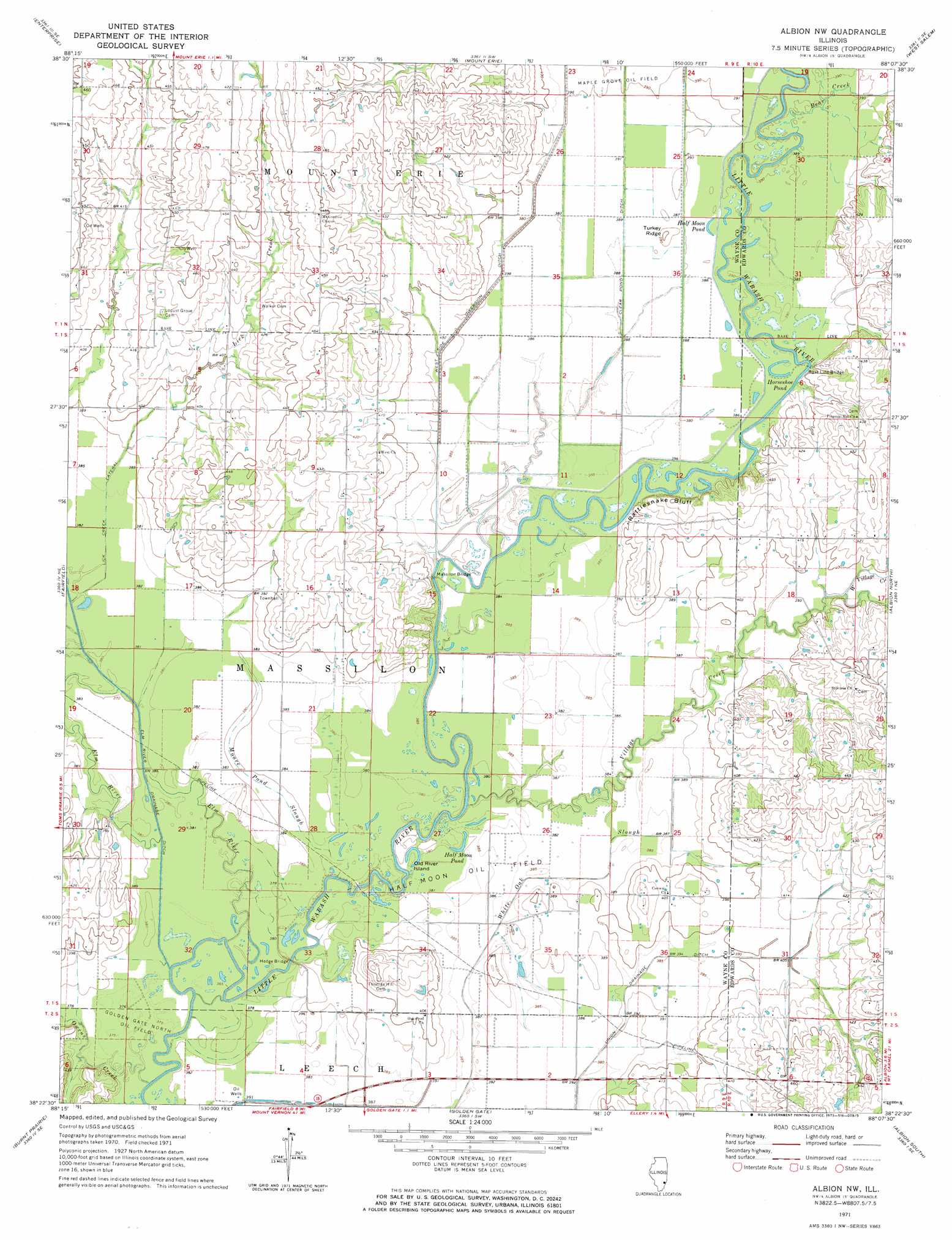
USGS Topo Quad 38088d2 - 1:24,000 scale
| Topo Map Name: | Albion Nw |
| USGS Topo Quad ID: | 38088d2 |
| Print Size: | ca. 21 1/4" wide x 27" high |
| Southeast Coordinates: | 38.375° N latitude / 88.125° W longitude |
| Map Center Coordinates: | 38.4375° N latitude / 88.1875° W longitude |
| U.S. State: | IL |
| Filename: | o38088d2.jpg |
| Download Map JPG Image: | Albion Nw topo map 1:24,000 scale |
| Map Type: | Topographic |
| Topo Series: | 7.5´ |
| Map Scale: | 1:24,000 |
| Source of Map Images: | United States Geological Survey (USGS) |
| Alternate Map Versions: |
Albion NW IL 1971, updated 1973 Download PDF Buy paper map Albion NW IL 2012 Download PDF Buy paper map Albion NW IL 2015 Download PDF Buy paper map |
1:24,000 Topo Quads surrounding Albion Nw
Flora |
Clay City |
Noble |
Olney |
Claremont |
Cisne |
Enterprise |
Mount Erie |
West Salem |
Berryville |
Geff |
Fairfield |
Albion Nw |
Albion North |
Bone Gap |
Boylestown |
Burnt Prairie |
Golden Gate |
Albion South |
Grayville |
Bungay |
Springerton |
Centerville |
Crossville |
New Harmony |
> Back to 38088a1 at 1:100,000 scale
> Back to 38088a1 at 1:250,000 scale
> Back to U.S. Topo Maps home
Albion Nw topo map: Gazetteer
Albion Nw: Areas
Burnt Prairie elevation 128m 419′Albion Nw: Bridges
Base Line Bridge elevation 116m 380′Hedge Bridge elevation 118m 387′
Massilon Bridge elevation 119m 390′
Albion Nw: Canals
Clear Pond Ditch elevation 119m 390′Lick Creek Lateral elevation 116m 380′
Union Drainage Ditch elevation 116m 380′
West Side Diversion Ditch elevation 122m 400′
Albion Nw: Cliffs
Rattlesnake Bluff elevation 119m 390′Albion Nw: Islands
Old River Island elevation 116m 380′Albion Nw: Lakes
Half Moon Pond elevation 116m 380′Half Moon Pond elevation 117m 383′
Horseshoe Pond elevation 117m 383′
Albion Nw: Oilfields
Golden Gate North Oil Field elevation 113m 370′Half Moon Oil Field elevation 117m 383′
Albion Nw: Populated Places
New Massillon (historical) elevation 128m 419′Albion Nw: Streams
Ash Slough elevation 113m 370′Bear Creek elevation 116m 380′
Clear Pond Slough elevation 118m 387′
Elm River elevation 113m 370′
Lick Creek elevation 119m 390′
Moore Pond Slough elevation 113m 370′
Owens Creek elevation 113m 370′
Village Creek elevation 113m 370′
West Village Creek elevation 119m 390′
Albion Nw: Summits
Turkey Ridge elevation 122m 400′Albion Nw digital topo map on disk
Buy this Albion Nw topo map showing relief, roads, GPS coordinates and other geographical features, as a high-resolution digital map file on DVD: