Waltonville Topo Map Illinois
To zoom in, hover over the map of Waltonville
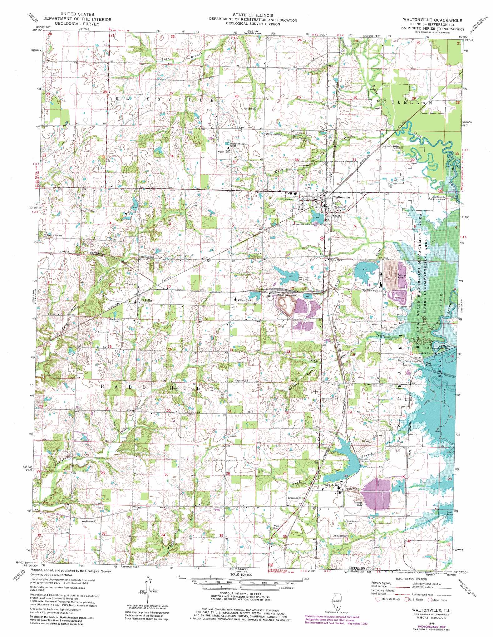
USGS Topo Quad 38089b1 - 1:24,000 scale
| Topo Map Name: | Waltonville |
| USGS Topo Quad ID: | 38089b1 |
| Print Size: | ca. 21 1/4" wide x 27" high |
| Southeast Coordinates: | 38.125° N latitude / 89° W longitude |
| Map Center Coordinates: | 38.1875° N latitude / 89.0625° W longitude |
| U.S. State: | IL |
| Filename: | o38089b1.jpg |
| Download Map JPG Image: | Waltonville topo map 1:24,000 scale |
| Map Type: | Topographic |
| Topo Series: | 7.5´ |
| Map Scale: | 1:24,000 |
| Source of Map Images: | United States Geological Survey (USGS) |
| Alternate Map Versions: |
Waltonville IL 1975, updated 1977 Download PDF Buy paper map Waltonville IL 1975, updated 1982 Download PDF Buy paper map Waltonville IL 1998, updated 2000 Download PDF Buy paper map Waltonville IL 2012 Download PDF Buy paper map Waltonville IL 2015 Download PDF Buy paper map |
1:24,000 Topo Quads surrounding Waltonville
Hoyleton |
Irvington |
Walnut Hill |
Kell |
Harmony |
Beaucoup |
Ashley |
Woodlawn |
Mount Vernon |
Opdyke |
Todds Mill |
Tamaroa |
Waltonville |
Ina |
Spring Garden |
Pyatts |
Du Quoin |
Sesser |
Rend Lake Dam |
Ewing |
Vergennes |
Elkville |
Christopher |
West Frankfort |
Thompsonville |
> Back to 38089a1 at 1:100,000 scale
> Back to 38088a1 at 1:250,000 scale
> Back to U.S. Topo Maps home
Waltonville topo map: Gazetteer
Waltonville: Dams
Auxiliary Reservoir Impoundment Structure Dam elevation 152m 498′Big Muddy Subimpoundment Dam elevation 122m 400′
East Lake Impoundment Dam elevation 140m 459′
Number 2 Portal Lake Dam elevation 155m 508′
Raw Water Reservoir Dam elevation 134m 439′
Waltonville Lake Dam elevation 139m 456′
Waltonville: Mines
Inland Mine elevation 137m 449′Orient Number 3 Mine elevation 151m 495′
Orient Number 6 Mine elevation 135m 442′
Waltonville: Parks
Nason Public Use Area elevation 125m 410′Rend Lake State Waterfowl Management Area elevation 125m 410′
Waltonville Public Use Area elevation 128m 419′
Waltonville: Populated Places
Emerson City elevation 141m 462′Fitzgerrell (historical) elevation 128m 419′
Scheller elevation 155m 508′
Waltonville elevation 141m 462′
Williamsburg elevation 149m 488′
Waltonville: Post Offices
Fitzgerrell Post Office (historical) elevation 128m 419′Scheller Post Office elevation 159m 521′
Waltonville: Reservoirs
Auxiliary Reservoir elevation 152m 498′East Lake Impoundment elevation 140m 459′
Number 2 Portal Lake elevation 155m 508′
Raw Water Reservoir elevation 134m 439′
Waltonville Lake elevation 139m 456′
Waltonville: Streams
Buck Creek elevation 124m 406′East Hurricane Creek elevation 122m 400′
Hartley Branch elevation 134m 439′
Knob Prairie Creek elevation 128m 419′
Rayse Creek elevation 122m 400′
Ward Branch elevation 124m 406′
Waltonville digital topo map on disk
Buy this Waltonville topo map showing relief, roads, GPS coordinates and other geographical features, as a high-resolution digital map file on DVD: