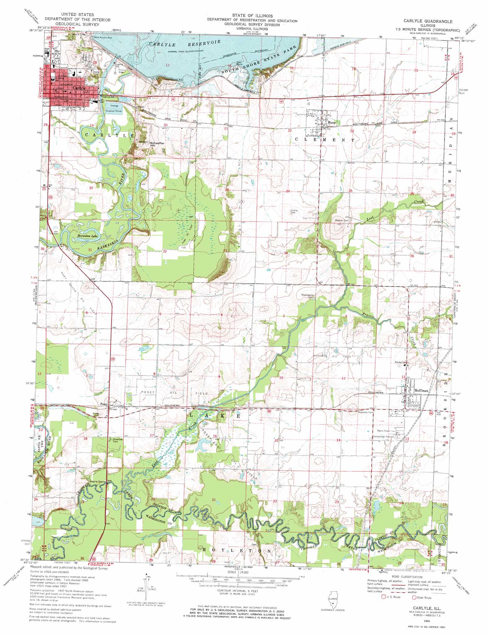
Carlyle Topo Map Illinois
To zoom in, hover over the map of Carlyle
USGS Topo Quad 38089e3 - 1:24,000 scale
| Topo Map Name: | Carlyle |
| USGS Topo Quad ID: | 38089e3 |
| Print Size: | ca. 21 1/4" wide x 27" high |
| Southeast Coordinates: | 38.5° N latitude / 89.25° W longitude |
| Map Center Coordinates: | 38.5625° N latitude / 89.3125° W longitude |
| U.S. State: | IL |
| Filename: | o38089e3.jpg |
| Download Map JPG Image: | Carlyle topo map 1:24,000 scale |
| Map Type: | Topographic |
| Topo Series: | 7.5´ |
| Map Scale: | 1:24,000 |
| Source of Map Images: | United States Geological Survey (USGS) |
| Alternate Map Versions: |
Carlyle IL 1969, updated 1971 Download PDF Buy paper map Carlyle IL 2012 Download PDF Buy paper map Carlyle IL 2015 Download PDF Buy paper map |
1:24,000 Topo Quads surrounding Carlyle
Pocahontas |
Beaver Creek |
Pleasant Mound |
Wildcat Lake |
Patoka |
Saint Rose |
Stolletown |
Keyesport |
Boulder |
Fairman |
Breese |
Beckemeyer |
Carlyle |
Centralia West |
Centralia East |
Okawville |
Addieville |
Hoyleton |
Irvington |
Walnut Hill |
Oakdale |
Nashville |
Beaucoup |
Ashley |
Woodlawn |
> Back to 38089e1 at 1:100,000 scale
> Back to 38088a1 at 1:250,000 scale
> Back to U.S. Topo Maps home
Carlyle topo map: Gazetteer
Carlyle: Airports
Twenhafel Field elevation 137m 449′Carlyle: Bridges
General Dean Bridge elevation 133m 436′Carlyle: Dams
Carlyle Dam elevation 136m 446′Saddle Dam Number 2 elevation 141m 462′
Carlyle: Lakes
Ash Lake elevation 128m 419′Horseshoe Lake elevation 128m 419′
Carlyle: Oilfields
Hoffman Oil Field elevation 137m 449′Huey Oil Field elevation 129m 423′
Huey South Oil Field elevation 135m 442′
Posey East Oil Field elevation 136m 446′
Posey Oil Field elevation 134m 439′
Carlyle: Parks
South Shore State Park elevation 136m 446′Spillway Recreation Area elevation 131m 429′
Carlyle: Populated Places
Carlyle elevation 139m 456′Hoffman elevation 139m 456′
Huey elevation 138m 452′
Posey elevation 138m 452′
Carlyle: Post Offices
Carlyle Post Office elevation 140m 459′Posey Post Office (historical) elevation 136m 446′
Carlyle: Streams
Lost Creek elevation 127m 416′Prairie Branch elevation 131m 429′
Prairie Creek elevation 128m 419′
Carlyle: Summits
Corcoran Hill elevation 163m 534′Schaeffer Hill elevation 161m 528′
Carlyle: Trails
Chipmunk Trail elevation 157m 515′Litle Prairie Nature Trail elevation 132m 433′
Carlyle digital topo map on disk
Buy this Carlyle topo map showing relief, roads, GPS coordinates and other geographical features, as a high-resolution digital map file on DVD: