Beckemeyer Topo Map Illinois
To zoom in, hover over the map of Beckemeyer
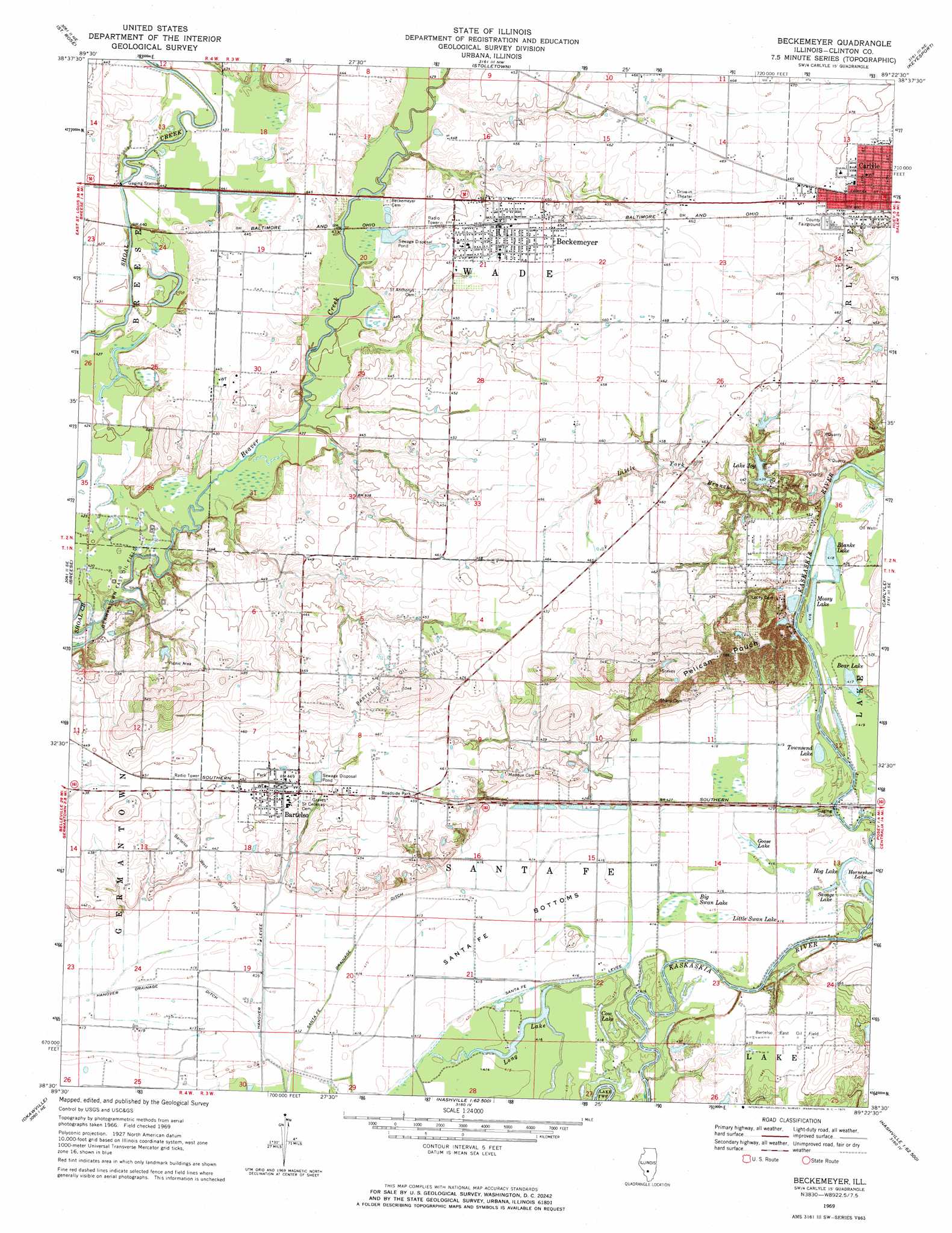
USGS Topo Quad 38089e4 - 1:24,000 scale
| Topo Map Name: | Beckemeyer |
| USGS Topo Quad ID: | 38089e4 |
| Print Size: | ca. 21 1/4" wide x 27" high |
| Southeast Coordinates: | 38.5° N latitude / 89.375° W longitude |
| Map Center Coordinates: | 38.5625° N latitude / 89.4375° W longitude |
| U.S. State: | IL |
| Filename: | o38089e4.jpg |
| Download Map JPG Image: | Beckemeyer topo map 1:24,000 scale |
| Map Type: | Topographic |
| Topo Series: | 7.5´ |
| Map Scale: | 1:24,000 |
| Source of Map Images: | United States Geological Survey (USGS) |
| Alternate Map Versions: |
Beckemeyer IL 1969, updated 1971 Download PDF Buy paper map Beckemeyer IL 2012 Download PDF Buy paper map Beckemeyer IL 2015 Download PDF Buy paper map |
1:24,000 Topo Quads surrounding Beckemeyer
Grantfork |
Pocahontas |
Beaver Creek |
Pleasant Mound |
Wildcat Lake |
Highland |
Saint Rose |
Stolletown |
Keyesport |
Boulder |
Trenton |
Breese |
Beckemeyer |
Carlyle |
Centralia West |
Venedy |
Okawville |
Addieville |
Hoyleton |
Irvington |
Saint Libory |
Oakdale |
Nashville |
Beaucoup |
Ashley |
> Back to 38089e1 at 1:100,000 scale
> Back to 38088a1 at 1:250,000 scale
> Back to U.S. Topo Maps home
Beckemeyer topo map: Gazetteer
Beckemeyer: Airports
Dennis Meier Heliport elevation 135m 442′Beckemeyer: Canals
Santa Fe Drainage Ditch elevation 125m 410′Beckemeyer: Dams
Greenville Old City Lake Dam elevation 134m 439′Lake Joy Dam elevation 134m 439′
Beckemeyer: Flats
Santa Fe Bottoms elevation 126m 413′Beckemeyer: Lakes
Bear Lake elevation 127m 416′Blanke Lake elevation 127m 416′
Bluff Lake (historical) elevation 132m 433′
Calamus Lake (historical) elevation 131m 429′
Club Lake elevation 126m 413′
Cow Lake elevation 125m 410′
Goose Lake elevation 126m 413′
Grassy Lake (historical) elevation 126m 413′
Hog Lake elevation 126m 413′
Horseshoe Lake elevation 126m 413′
Little Swan Lake elevation 126m 413′
Long Lake elevation 125m 410′
Mossy Lake elevation 127m 416′
Savage Lake elevation 126m 413′
Townsend Lake elevation 127m 416′
Beckemeyer: Levees
Hanover Levee elevation 125m 410′Santa Fe Levee elevation 126m 413′
Beckemeyer: Oilfields
Bartelso East Oil Field elevation 135m 442′Bartelso Oil Field elevation 145m 475′
Bartelso West Oil Field elevation 130m 426′
Germantown East Oil Field elevation 128m 419′
Beckemeyer: Populated Places
Bartelso elevation 137m 449′Beckemeyer elevation 140m 459′
Royal Lake Resort elevation 139m 456′
Snearlyville elevation 131m 429′
Beckemeyer: Reservoirs
Greenville Old City Lake elevation 134m 439′Lake Joy elevation 134m 439′
Beckemeyer: Ridges
Pelican Pouch elevation 170m 557′Beckemeyer: Streams
Beaver Creek elevation 125m 410′Little York Branch elevation 125m 410′
Beckemeyer: Swamps
Big Swan Lake elevation 126m 413′Beckemeyer digital topo map on disk
Buy this Beckemeyer topo map showing relief, roads, GPS coordinates and other geographical features, as a high-resolution digital map file on DVD: