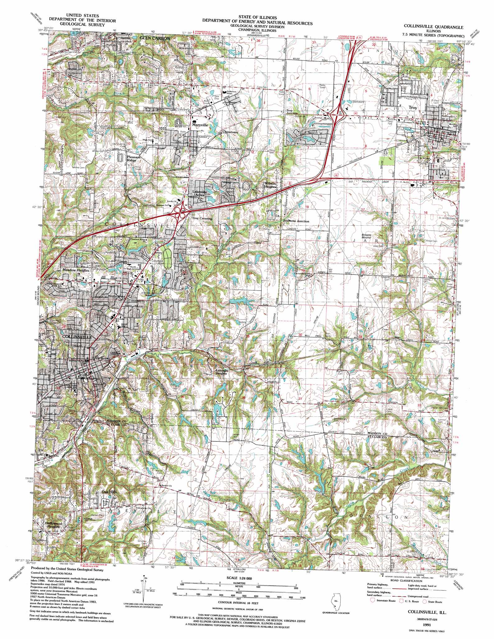
Collinsville Topo Map Illinois
To zoom in, hover over the map of Collinsville
USGS Topo Quad 38089f8 - 1:24,000 scale
| Topo Map Name: | Collinsville |
| USGS Topo Quad ID: | 38089f8 |
| Print Size: | ca. 21 1/4" wide x 27" high |
| Southeast Coordinates: | 38.625° N latitude / 89.875° W longitude |
| Map Center Coordinates: | 38.6875° N latitude / 89.9375° W longitude |
| U.S. State: | IL |
| Filename: | o38089f8.jpg |
| Download Map JPG Image: | Collinsville topo map 1:24,000 scale |
| Map Type: | Topographic |
| Topo Series: | 7.5´ |
| Map Scale: | 1:24,000 |
| Source of Map Images: | United States Geological Survey (USGS) |
| Alternate Map Versions: |
Collinsville IL 1937, updated 1937 Download PDF Buy paper map Collinsville IL 1954, updated 1959 Download PDF Buy paper map Collinsville IL 1954, updated 1969 Download PDF Buy paper map Collinsville IL 1954, updated 1975 Download PDF Buy paper map Collinsville IL 1954, updated 1986 Download PDF Buy paper map Collinsville IL 1991, updated 1991 Download PDF Buy paper map Collinsville IL 2012 Download PDF Buy paper map Collinsville IL 2015 Download PDF Buy paper map |
1:24,000 Topo Quads surrounding Collinsville
Alton |
Bethalto |
Prairietown |
Worden |
New Douglas |
Columbia Bottom |
Wood River |
Edwardsville |
Marine |
Grantfork |
Granite City |
Monks Mound |
Collinsville |
Saint Jacob |
Highland |
Cahokia |
French Village |
O'Fallon |
Lebanon |
Trenton |
Columbia |
Millstadt |
Freeburg |
Mascoutah |
Venedy |
> Back to 38089e1 at 1:100,000 scale
> Back to 38088a1 at 1:250,000 scale
> Back to U.S. Topo Maps home
Collinsville topo map: Gazetteer
Collinsville: Airports
Anderson Hospital Heliport elevation 180m 590′Collinsville: Crossings
Interchange 15 elevation 175m 574′Interchange 17 elevation 173m 567′
Interchange 18 elevation 176m 577′
Collinsville: Dams
Bauers Lake Dam elevation 174m 570′Kapes Lake Dam elevation 166m 544′
Lake Hillcrest Dam elevation 157m 515′
Magin Lake Dam elevation 164m 538′
Marysville Fishing Club Lake Dam elevation 177m 580′
Pine Lake Dam elevation 163m 534′
Collinsville: Parks
City Park elevation 170m 557′Drost Park elevation 174m 570′
Firemans Park elevation 177m 580′
Glidden City Park elevation 159m 521′
Troy City Park elevation 171m 561′
Woodland City Park elevation 156m 511′
Collinsville: Populated Places
Chinatown elevation 178m 583′Collinsville elevation 171m 561′
Donkville elevation 157m 515′
Formosa Junction elevation 167m 547′
Glen Carbon elevation 142m 465′
Hollywood Heights elevation 173m 567′
Lakeview Acres elevation 180m 590′
Lumaghi Heights elevation 172m 564′
Maryville elevation 176m 577′
Meadow Heights elevation 165m 541′
Oak Hills elevation 176m 577′
Pleasant Ridge elevation 171m 561′
Troy elevation 171m 561′
Troy Crossing elevation 171m 561′
Troy Junction elevation 175m 574′
Wilson Heights elevation 172m 564′
Collinsville: Post Offices
Collinsville Post Office elevation 171m 561′Troy Post Office elevation 171m 561′
Collinsville: Reservoirs
Bauers Lake elevation 174m 570′Kapes Lake elevation 166m 544′
Lake Hillcrest elevation 157m 515′
Magin Lake elevation 164m 538′
Marysville Fishing Club Lake elevation 177m 580′
Pine Lake elevation 163m 534′
Collinsville: Summits
Browns Mound elevation 174m 570′Collinsville digital topo map on disk
Buy this Collinsville topo map showing relief, roads, GPS coordinates and other geographical features, as a high-resolution digital map file on DVD: