Prairie Du Rocher Topo Map Illinois
To zoom in, hover over the map of Prairie Du Rocher
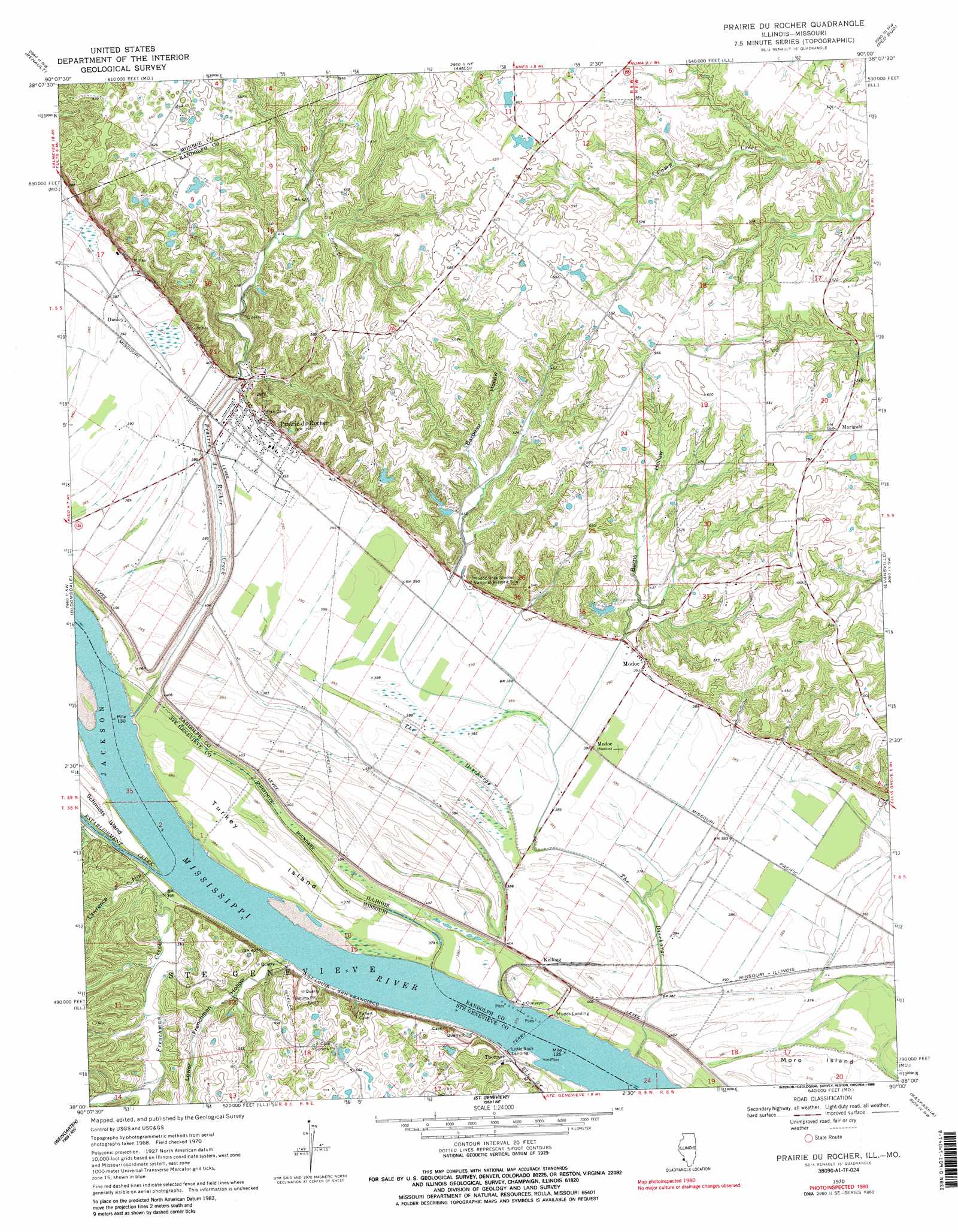
USGS Topo Quad 38090a1 - 1:24,000 scale
| Topo Map Name: | Prairie Du Rocher |
| USGS Topo Quad ID: | 38090a1 |
| Print Size: | ca. 21 1/4" wide x 27" high |
| Southeast Coordinates: | 38° N latitude / 90° W longitude |
| Map Center Coordinates: | 38.0625° N latitude / 90.0625° W longitude |
| U.S. States: | IL, MO |
| Filename: | o38090a1.jpg |
| Download Map JPG Image: | Prairie Du Rocher topo map 1:24,000 scale |
| Map Type: | Topographic |
| Topo Series: | 7.5´ |
| Map Scale: | 1:24,000 |
| Source of Map Images: | United States Geological Survey (USGS) |
| Alternate Map Versions: |
Prairie Du Rocher IL 1970, updated 1972 Download PDF Buy paper map Prairie Du Rocher IL 1970, updated 1988 Download PDF Buy paper map Prairie Du Rocher IL 1970, updated 1988 Download PDF Buy paper map Prairie Du Rocher IL 1993, updated 1996 Download PDF Buy paper map Prairie du Rocher IL 2012 Download PDF Buy paper map Prairie du Rocher IL 2015 Download PDF Buy paper map |
1:24,000 Topo Quads surrounding Prairie Du Rocher
Valmeyer |
Waterloo |
Paderborn |
New Athens West |
New Athens East |
Selma |
Renault |
Ames |
Red Bud |
Baldwin |
Danby |
Bloomsdale |
Prairie Du Rocher |
Evansville |
Walsh |
Lawrenceton |
Weingarten |
Sainte Genevieve |
Kaskaskia |
Chester |
Sprott |
Coffman |
Minnith |
Lithium |
Belgique |
> Back to 38090a1 at 1:100,000 scale
> Back to 38090a1 at 1:250,000 scale
> Back to U.S. Topo Maps home
Prairie Du Rocher topo map: Gazetteer
Prairie Du Rocher: Dams
Fort Charters Sportsmans Club Lake Dam elevation 138m 452′Kertz Farms Lake Dam elevation 148m 485′
Prairie Du Rocher: Flats
Prairie Du Rocher elevation 116m 380′Prairie Du Rocher: Islands
Turkey Island elevation 116m 380′Prairie Du Rocher: Mines
Government Limestone Quarry elevation 128m 419′Prairie Du Rocher: Parks
Modoc Rock Shelter National Historic Site elevation 131m 429′Prairie Du Rocher: Populated Places
Danley elevation 118m 387′Kellogg elevation 116m 380′
Little Rock Landing elevation 112m 367′
Marigold elevation 173m 567′
Modoc elevation 122m 400′
Prairie du Rocher elevation 120m 393′
Thomure elevation 119m 390′
Prairie Du Rocher: Post Offices
Modoc Post Office elevation 121m 396′Prairie Du Rocher: Reservoirs
Fort Charters Sportsmans Club Lake elevation 138m 452′Prairie Du Rocher: Streams
Establishment Creek elevation 111m 364′Frenchman Creek elevation 112m 367′
Prairie du Rocher Creek elevation 113m 370′
Sugar Bottom Creek elevation 131m 429′
The Discharge elevation 114m 374′
Prairie Du Rocher: Valleys
Barbeau Hollow elevation 124m 406′Burns Hollow elevation 121m 396′
Lawrence Hollow elevation 117m 383′
Lower Frenchman Hollow elevation 120m 393′
Magnolia Hollow elevation 118m 387′
Prairie Du Rocher digital topo map on disk
Buy this Prairie Du Rocher topo map showing relief, roads, GPS coordinates and other geographical features, as a high-resolution digital map file on DVD: