Old Mines Topo Map Missouri
To zoom in, hover over the map of Old Mines
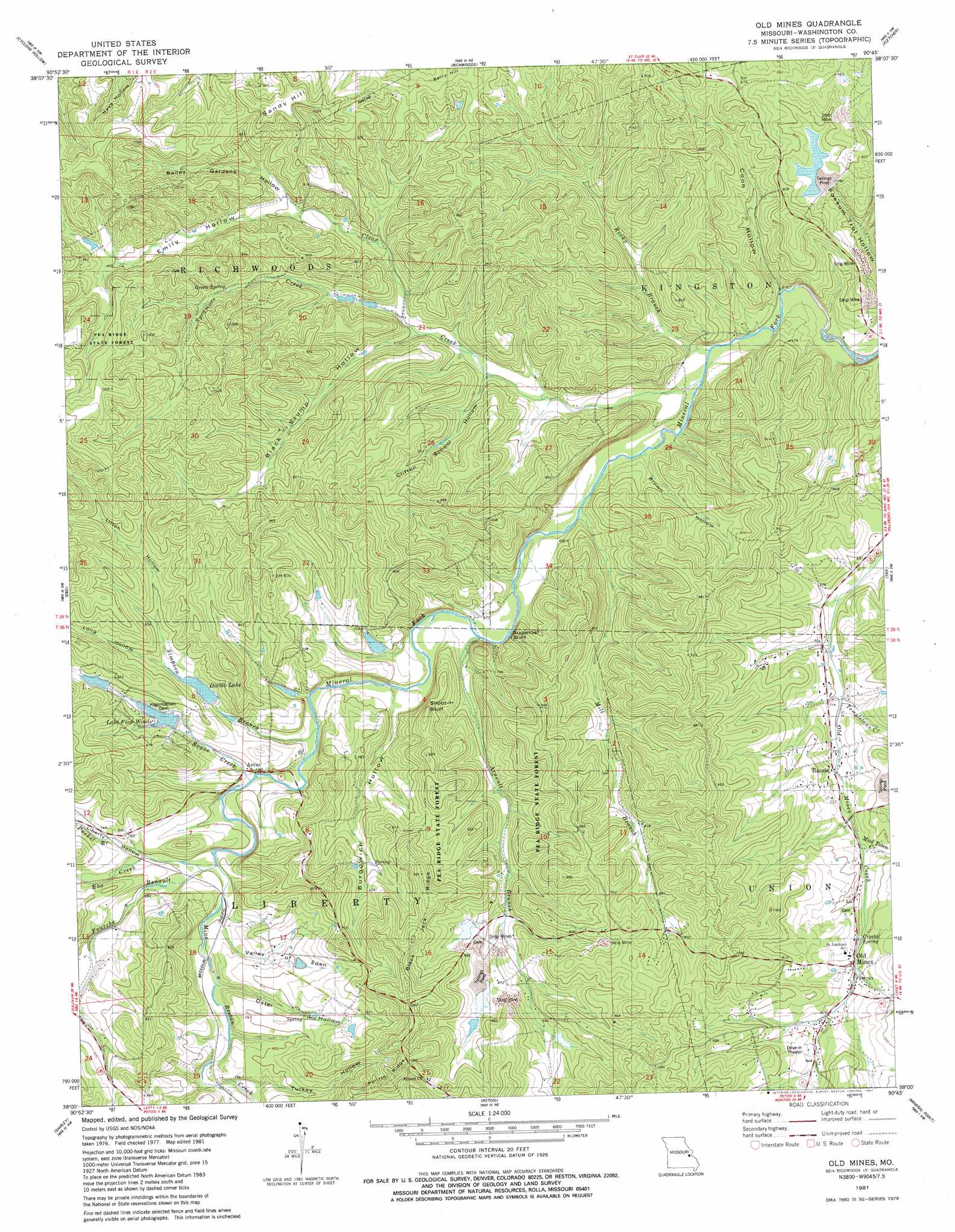
USGS Topo Quad 38090a7 - 1:24,000 scale
| Topo Map Name: | Old Mines |
| USGS Topo Quad ID: | 38090a7 |
| Print Size: | ca. 21 1/4" wide x 27" high |
| Southeast Coordinates: | 38° N latitude / 90.75° W longitude |
| Map Center Coordinates: | 38.0625° N latitude / 90.8125° W longitude |
| U.S. State: | MO |
| Filename: | o38090a7.jpg |
| Download Map JPG Image: | Old Mines topo map 1:24,000 scale |
| Map Type: | Topographic |
| Topo Series: | 7.5´ |
| Map Scale: | 1:24,000 |
| Source of Map Images: | United States Geological Survey (USGS) |
| Alternate Map Versions: |
Old Mines MO 1981, updated 1981 Download PDF Buy paper map Old Mines MO 2012 Download PDF Buy paper map Old Mines MO 2015 Download PDF Buy paper map |
1:24,000 Topo Quads surrounding Old Mines
Stanton |
Saint Clair |
Lonedell |
Cedar Hill |
Belew Creek |
Meramec State Park |
Cyclone Hollow |
Richwoods |
Fletcher |
Desoto |
Anthonies Mill |
Ebo |
Old Mines |
Tiff |
Vineland |
Berryman |
Shirley |
Potosi |
Mineral Point |
Bonne Terre |
Courtois |
Palmer |
Belgrade |
Irondale |
Flat River |
> Back to 38090a1 at 1:100,000 scale
> Back to 38090a1 at 1:250,000 scale
> Back to U.S. Topo Maps home
Old Mines topo map: Gazetteer
Old Mines: Cliffs
Shoot-in Bluff elevation 240m 787′Sugarloaf Bluff elevation 231m 757′
Twin Cliffs elevation 201m 659′
Old Mines: Dams
Arnault Branch Mine Dam elevation 276m 905′Four Winds Way Dam elevation 220m 721′
Jones Lake Dam elevation 209m 685′
Number 875 Dam elevation 224m 734′
Pfizer Incorporated Lake Dam elevation 214m 702′
Pioneer Rod and Gun Club Dam elevation 280m 918′
Racola Tailings Dam elevation 241m 790′
Sampson Lake Dam elevation 277m 908′
Star Mine Dam elevation 216m 708′
Old Mines: Mines
Bee Lead Diggings elevation 264m 866′Bourgawich Lead Mine elevation 249m 816′
Cliff Cave Mine elevation 215m 705′
Crawfish Lead Diggings elevation 214m 702′
Dry Hollow Lead Diggings elevation 219m 718′
DuCloes Lead Diggings elevation 236m 774′
Elliot Lead Diggings elevation 183m 600′
Flynns Lead Diggings elevation 193m 633′
Gobbetts Lead Diggings elevation 285m 935′
Hunts Lead Diggings elevation 208m 682′
Old Prairie Lead Diggings elevation 274m 898′
Scott Lead Diggings elevation 272m 892′
Shores Lead Mine elevation 271m 889′
Somers Lead Diggings elevation 232m 761′
Wet Lead Diggings elevation 191m 626′
Old Mines: Populated Places
Aptus elevation 210m 688′Old Mines elevation 240m 787′
Racola elevation 225m 738′
Robidoux elevation 241m 790′
Old Mines: Reservoirs
Diablo Lake elevation 225m 738′Four Winds Way Reservoir elevation 220m 721′
Lake Four Winds elevation 231m 757′
Old Mines: Ridges
Black Jack Ridge elevation 305m 1000′Chambo Ridge elevation 257m 843′
Politte Ridge elevation 325m 1066′
Old Mines: Springs
Crystal Spring elevation 243m 797′Green Spring elevation 250m 820′
Old Mines: Streams
Arnault Branch elevation 197m 646′Bourgawich Branch elevation 201m 659′
Clear Creek elevation 185m 606′
Crawfish Branch elevation 223m 731′
Ebo Creek elevation 213m 698′
Fourche a Renault elevation 207m 679′
Mill Branch elevation 192m 629′
Mine a Breton Creek elevation 207m 679′
Mud Town Creek elevation 232m 761′
Old Prairie Branch elevation 202m 662′
Pucket Branch elevation 213m 698′
Robidoux Branch elevation 206m 675′
Rocky Branch elevation 186m 610′
Rogue Creek elevation 204m 669′
Simpson Branch elevation 209m 685′
Sycamore Creek elevation 209m 685′
Templetown Creek elevation 211m 692′
Old Mines: Summits
Sandy Hill elevation 307m 1007′Old Mines: Valleys
Bailey Gardens Hollow elevation 238m 780′Black Stump Hollow elevation 212m 695′
Brown Hollow elevation 189m 620′
Burgowich Hollow elevation 204m 669′
Clifton School Hollow elevation 201m 659′
Coon Hollow elevation 184m 603′
Emily Hollow elevation 238m 780′
Liberty Hollow elevation 216m 708′
Liberty Hollow elevation 207m 679′
Litton Hollow elevation 235m 770′
Long Hollow elevation 229m 751′
Oster Hollow elevation 213m 698′
Turkey Hollow elevation 219m 718′
Valley of Eden elevation 209m 685′
Old Mines digital topo map on disk
Buy this Old Mines topo map showing relief, roads, GPS coordinates and other geographical features, as a high-resolution digital map file on DVD: