Ebo Topo Map Missouri
To zoom in, hover over the map of Ebo
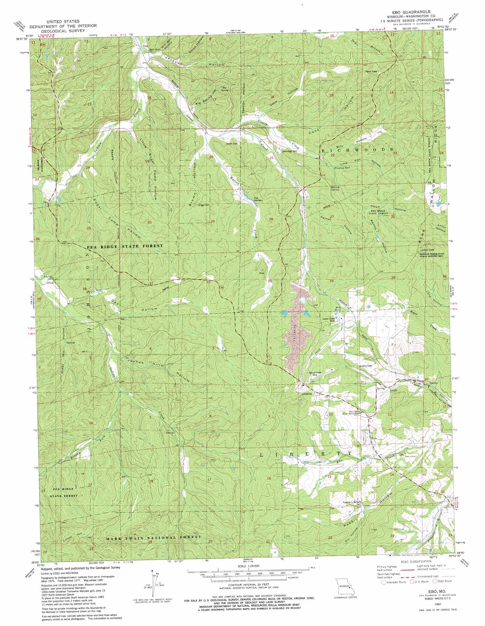
USGS Topo Quad 38090a8 - 1:24,000 scale
| Topo Map Name: | Ebo |
| USGS Topo Quad ID: | 38090a8 |
| Print Size: | ca. 21 1/4" wide x 27" high |
| Southeast Coordinates: | 38° N latitude / 90.875° W longitude |
| Map Center Coordinates: | 38.0625° N latitude / 90.9375° W longitude |
| U.S. State: | MO |
| Filename: | o38090a8.jpg |
| Download Map JPG Image: | Ebo topo map 1:24,000 scale |
| Map Type: | Topographic |
| Topo Series: | 7.5´ |
| Map Scale: | 1:24,000 |
| Source of Map Images: | United States Geological Survey (USGS) |
| Alternate Map Versions: |
Ebo MO 1981, updated 1981 Download PDF Buy paper map Ebo MO 2012 Download PDF Buy paper map Ebo MO 2015 Download PDF Buy paper map |
| FStopo: | US Forest Service topo Ebo is available: Download FStopo PDF Download FStopo TIF |
1:24,000 Topo Quads surrounding Ebo
Spring Bluff |
Stanton |
Saint Clair |
Lonedell |
Cedar Hill |
Sullivan |
Meramec State Park |
Cyclone Hollow |
Richwoods |
Fletcher |
Onondaga Cave |
Anthonies Mill |
Ebo |
Old Mines |
Tiff |
Huzzah |
Berryman |
Shirley |
Potosi |
Mineral Point |
Davisville |
Courtois |
Palmer |
Belgrade |
Irondale |
> Back to 38090a1 at 1:100,000 scale
> Back to 38090a1 at 1:250,000 scale
> Back to U.S. Topo Maps home
Ebo topo map: Gazetteer
Ebo: Basins
Bear Wallow elevation 342m 1122′Ebo: Dams
Indian Creek Mine Lower Dam elevation 268m 879′Indian Creek Mine Upper Dam elevation 299m 980′
Ebo: Mines
Indian Creek Mine elevation 293m 961′Indian Creek Mine elevation 301m 987′
Ebo: Populated Places
Ebo elevation 260m 853′Fourche a Renault (historical) elevation 221m 725′
Northcut elevation 201m 659′
Ebo: Reservoirs
Indian Creek Mine Tailings Pond elevation 268m 879′Ebo: Ridges
Bear Wallow Ridge elevation 333m 1092′Ebo: Springs
Bainey Spring elevation 262m 859′Big Spring elevation 251m 823′
Ebo: Streams
Brushy Fork elevation 251m 823′Goose Creek elevation 202m 662′
Pinery Creek elevation 219m 718′
Watson Creek elevation 214m 702′
Ebo: Summits
Litton Hill elevation 384m 1259′Ebo: Valleys
Bainey Hollow elevation 265m 869′Bessie Hollow elevation 208m 682′
Big Spring Hollow elevation 210m 688′
Billy Hollow elevation 244m 800′
Brown Hollow elevation 214m 702′
Conk Hollow elevation 227m 744′
Day Hollow elevation 242m 793′
Dry Hollow elevation 262m 859′
Floyd Hollow elevation 265m 869′
Jackson Hollow elevation 201m 659′
Joshua Hill Hollow elevation 253m 830′
Lime Kiln Hollow elevation 244m 800′
Little Sugar Camp Hollow elevation 206m 675′
Onion Hollow elevation 209m 685′
Patton Hollow elevation 244m 800′
Rabbit Hollow elevation 235m 770′
Section Hollow elevation 220m 721′
Sugar Camp Hollow elevation 216m 708′
Valle Hollow elevation 224m 734′
Will Wet Hollow elevation 204m 669′
Ebo: Wells
Flowing Well elevation 247m 810′Ebo digital topo map on disk
Buy this Ebo topo map showing relief, roads, GPS coordinates and other geographical features, as a high-resolution digital map file on DVD: