Richwoods Topo Map Missouri
To zoom in, hover over the map of Richwoods
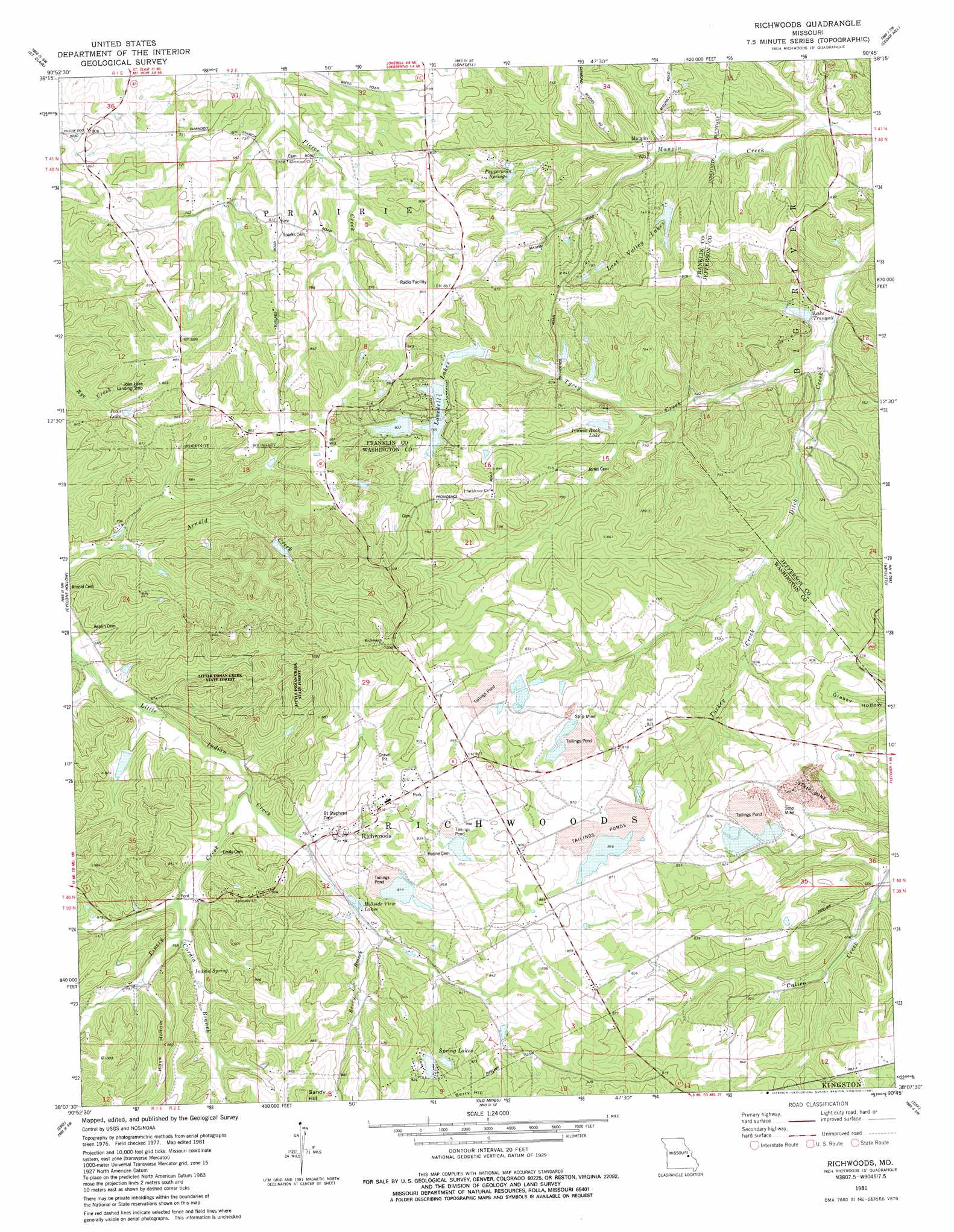
USGS Topo Quad 38090b7 - 1:24,000 scale
| Topo Map Name: | Richwoods |
| USGS Topo Quad ID: | 38090b7 |
| Print Size: | ca. 21 1/4" wide x 27" high |
| Southeast Coordinates: | 38.125° N latitude / 90.75° W longitude |
| Map Center Coordinates: | 38.1875° N latitude / 90.8125° W longitude |
| U.S. State: | MO |
| Filename: | o38090b7.jpg |
| Download Map JPG Image: | Richwoods topo map 1:24,000 scale |
| Map Type: | Topographic |
| Topo Series: | 7.5´ |
| Map Scale: | 1:24,000 |
| Source of Map Images: | United States Geological Survey (USGS) |
| Alternate Map Versions: |
Richwoods MO 1981, updated 1981 Download PDF Buy paper map Richwoods MO 2012 Download PDF Buy paper map Richwoods MO 2015 Download PDF Buy paper map |
1:24,000 Topo Quads surrounding Richwoods
Union |
Moselle |
Gray Summit |
Pacific |
House Springs |
Stanton |
Saint Clair |
Lonedell |
Cedar Hill |
Belew Creek |
Meramec State Park |
Cyclone Hollow |
Richwoods |
Fletcher |
Desoto |
Anthonies Mill |
Ebo |
Old Mines |
Tiff |
Vineland |
Berryman |
Shirley |
Potosi |
Mineral Point |
Bonne Terre |
> Back to 38090a1 at 1:100,000 scale
> Back to 38090a1 at 1:250,000 scale
> Back to U.S. Topo Maps home
Richwoods topo map: Gazetteer
Richwoods: Airports
Joan Lake Airport elevation 239m 784′Richwoods: Dams
Alpine Lake Dam elevation 211m 692′Assaf Lake Dam elevation 224m 734′
Big Four Mine Dam elevation 238m 780′
Click Lake Dam elevation 242m 793′
Cool Valley Lake Dam elevation 208m 682′
Davis Lake Dam elevation 287m 941′
Desoto Mining Comapny Pit and Plant A Dam elevation 250m 820′
Desoto Mining Company Pit and Plant B Dam elevation 243m 797′
Ditch Creek Dam elevation 255m 836′
Hoffman Lake Dam elevation 252m 826′
Indian Rock Lake Dam elevation 224m 734′
Lake Aggravation Dam elevation 227m 744′
Lake Aggravation Dam elevation 233m 764′
Lake Tranquil Dam elevation 170m 557′
Little Indian Creek Dam elevation 232m 761′
Lonedell Lake Dam elevation 241m 790′
Lost Valley Lake West Dam elevation 217m 711′
Mononame 551 Dam elevation 250m 820′
Mononame 558 Dam elevation 276m 905′
Mononame 563 Dam elevation 242m 793′
Perkins East Lower Lake Dam elevation 193m 633′
Perkins East Upper Lake Dam elevation 220m 721′
Perkins West Lake Dam elevation 217m 711′
Pierce Lake Dam elevation 256m 839′
Richwoods Mine B Mill Dam elevation 266m 872′
Richwoods Pond Dam elevation 256m 839′
Spring Lake Dam elevation 256m 839′
Stieren Lake Dam elevation 241m 790′
Richwoods: Mines
Board Lead Diggings elevation 254m 833′French Lead Diggings elevation 257m 843′
La Beaume Lead Diggings elevation 263m 862′
Mundy Lead Diggings elevation 256m 839′
Richwoods Lead Mine elevation 258m 846′
Sixteenth Section Lead Diggings elevation 244m 800′
Skewes Lead Diggings elevation 228m 748′
The Fraction Lead Diggings elevation 265m 869′
Richwoods: Populated Places
Hensley elevation 246m 807′Hurricane elevation 306m 1003′
Maupin elevation 189m 620′
Richwoods elevation 247m 810′
Richwoods: Reservoirs
Hillside View Lake elevation 227m 744′Indian Rock Lake elevation 224m 734′
Joan Lake elevation 238m 780′
Lake Tranquil elevation 173m 567′
Lake Tranquill elevation 170m 557′
Londell Lake elevation 241m 790′
Lonedell Lakes elevation 227m 744′
Lost Valley Lakes elevation 211m 692′
Pierce Lake elevation 256m 839′
Spring Lake elevation 256m 839′
Spring Lakes elevation 264m 866′
Richwoods: Springs
Indian Spring elevation 238m 780′Pepermint Springs elevation 220m 721′
Richwoods: Streams
Berry Branch elevation 231m 757′Cordia Branch elevation 232m 761′
Papoose Creek elevation 217m 711′
Pinery Creek elevation 213m 698′
Taggett Branch elevation 205m 672′
Turkey Creek elevation 188m 616′
Tyrey Creek elevation 163m 534′
Richwoods: Summits
Berry Hill elevation 293m 961′Richwoods: Valleys
Hays Hollow elevation 240m 787′Richwoods digital topo map on disk
Buy this Richwoods topo map showing relief, roads, GPS coordinates and other geographical features, as a high-resolution digital map file on DVD: