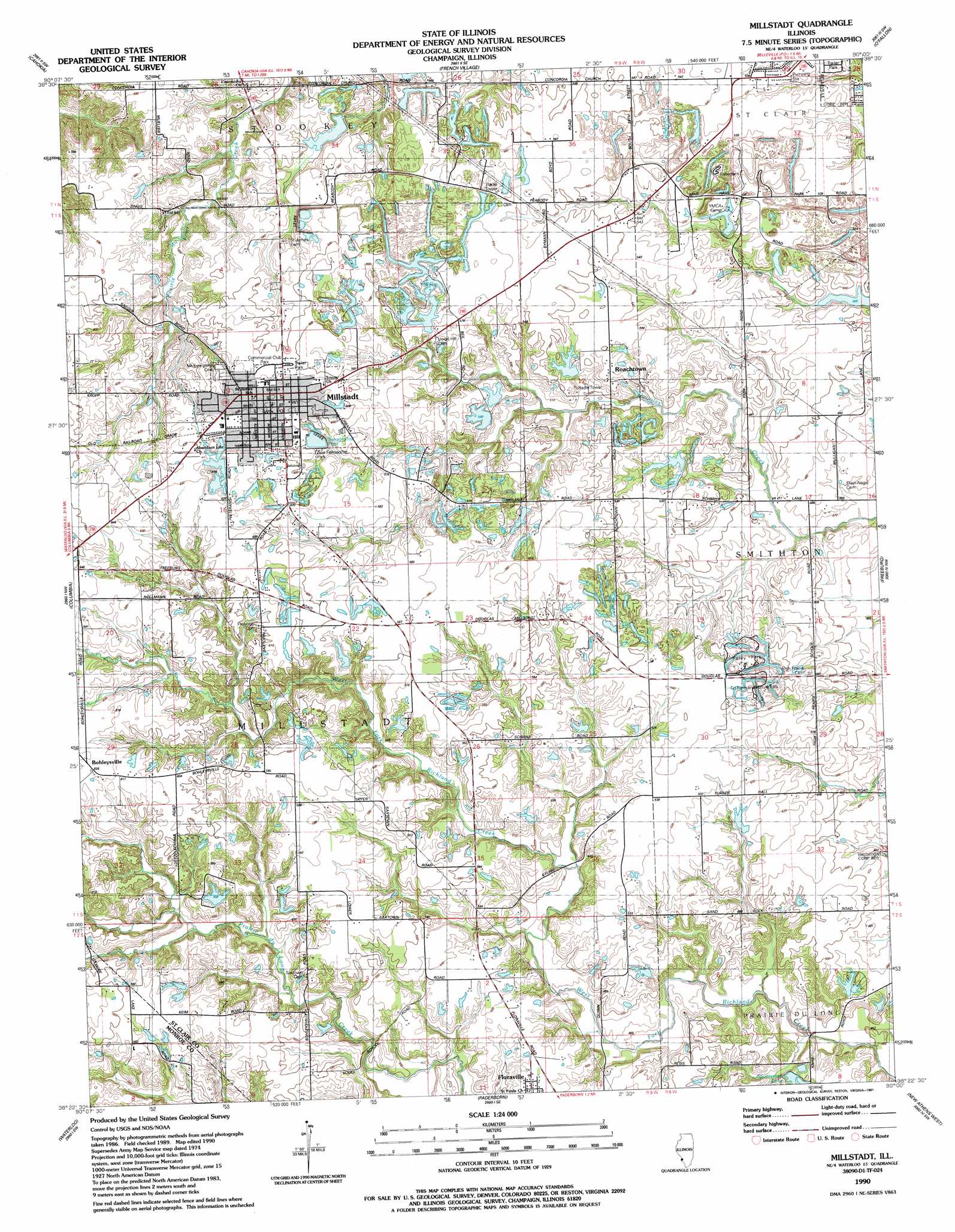
Millstadt Topo Map Illinois
To zoom in, hover over the map of Millstadt
USGS Topo Quad 38090d1 - 1:24,000 scale
| Topo Map Name: | Millstadt |
| USGS Topo Quad ID: | 38090d1 |
| Print Size: | ca. 21 1/4" wide x 27" high |
| Southeast Coordinates: | 38.375° N latitude / 90° W longitude |
| Map Center Coordinates: | 38.4375° N latitude / 90.0625° W longitude |
| U.S. State: | IL |
| Filename: | o38090d1.jpg |
| Download Map JPG Image: | Millstadt topo map 1:24,000 scale |
| Map Type: | Topographic |
| Topo Series: | 7.5´ |
| Map Scale: | 1:24,000 |
| Source of Map Images: | United States Geological Survey (USGS) |
| Alternate Map Versions: |
Millstadt IL 1954, updated 1959 Download PDF Buy paper map Millstadt IL 1954, updated 1969 Download PDF Buy paper map Millstadt IL 1954, updated 1975 Download PDF Buy paper map Millstadt IL 1990, updated 1991 Download PDF Buy paper map Millstadt IL 2012 Download PDF Buy paper map Millstadt IL 2015 Download PDF Buy paper map |
1:24,000 Topo Quads surrounding Millstadt
Clayton |
Granite City |
Monks Mound |
Collinsville |
Saint Jacob |
Webster Groves |
Cahokia |
French Village |
O'Fallon |
Lebanon |
Oakville |
Columbia |
Millstadt |
Freeburg |
Mascoutah |
Valmeyer |
Waterloo |
Paderborn |
New Athens West |
New Athens East |
Selma |
Renault |
Ames |
Red Bud |
Baldwin |
> Back to 38090a1 at 1:100,000 scale
> Back to 38090a1 at 1:250,000 scale
> Back to U.S. Topo Maps home
Millstadt topo map: Gazetteer
Millstadt: Dams
Beil Lake Number 1 East Dam elevation 157m 515′Beil Lake Number 1 North Dam Number 2 elevation 168m 551′
Beil Lake Number 2 Dam elevation 162m 531′
Illinois No Name Number 362 Dam elevation 171m 561′
Millstadt Sportsmans Club Lake Dam elevation 156m 511′
New West Fork Club Lake Dam elevation 151m 495′
Roachtown Lake Dam elevation 155m 508′
Smithton Sportmans Club Lake Dam elevation 141m 462′
YMCA Camp Lake Dam elevation 156m 511′
Millstadt: Lakes
Sportsman Lake elevation 149m 488′Millstadt: Mines
Diamond Joe Mine elevation 167m 547′Millstadt: Parks
Commercial Club Park elevation 185m 606′Foley Park elevation 171m 561′
Saint Clair County Farm and Nature Park elevation 171m 561′
Zion Fellowship Park elevation 183m 600′
Millstadt: Populated Places
Bohleysville elevation 188m 616′Floraville elevation 160m 524′
Millstadt elevation 188m 616′
Roachtown elevation 165m 541′
Millstadt: Post Offices
Millstadt Post Office elevation 188m 616′Millstadt: Reservoirs
Beil Lake Number 1 East Reservoir elevation 157m 515′Beil Lake Number 1 North Dam Number 2 elevation 168m 551′
Beil Lake Number 2 elevation 162m 531′
Millstadt Sportsmans Club Lake elevation 156m 511′
New West Fork Club Lake elevation 151m 495′
Roachtown Lake elevation 155m 508′
Smithton Sportmans Club Lake elevation 141m 462′
YMCA Camp Lake elevation 156m 511′
Millstadt digital topo map on disk
Buy this Millstadt topo map showing relief, roads, GPS coordinates and other geographical features, as a high-resolution digital map file on DVD: