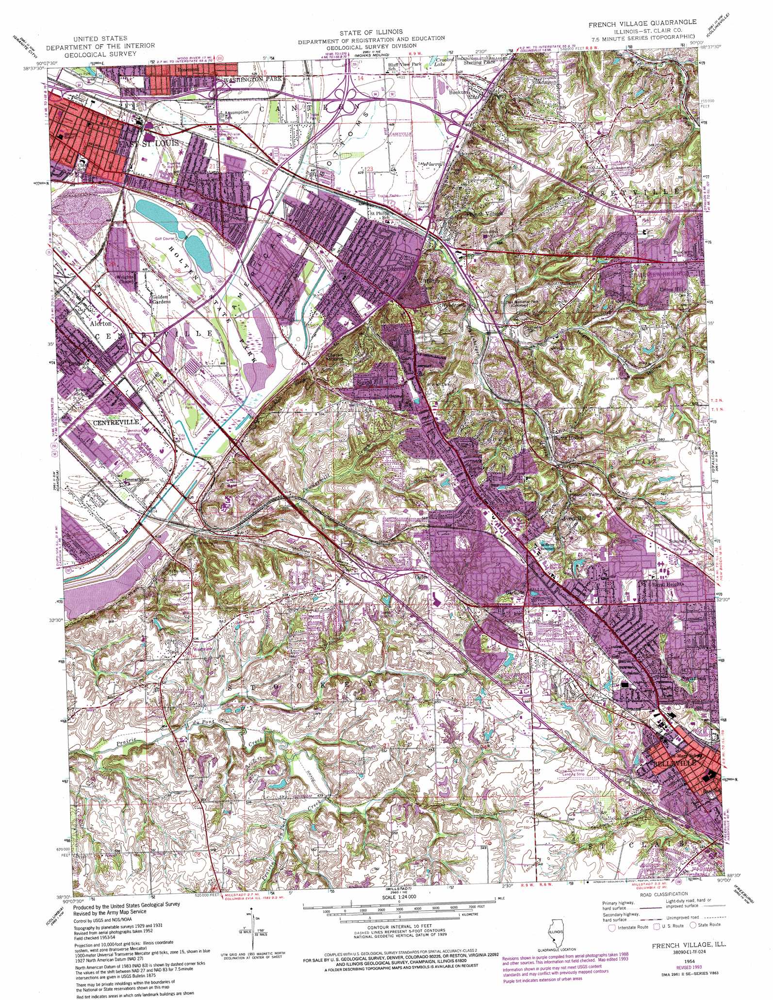
French Village Topo Map Illinois
To zoom in, hover over the map of French Village
USGS Topo Quad 38090e1 - 1:24,000 scale
| Topo Map Name: | French Village |
| USGS Topo Quad ID: | 38090e1 |
| Print Size: | ca. 21 1/4" wide x 27" high |
| Southeast Coordinates: | 38.5° N latitude / 90° W longitude |
| Map Center Coordinates: | 38.5625° N latitude / 90.0625° W longitude |
| U.S. State: | IL |
| Filename: | o38090e1.jpg |
| Download Map JPG Image: | French Village topo map 1:24,000 scale |
| Map Type: | Topographic |
| Topo Series: | 7.5´ |
| Map Scale: | 1:24,000 |
| Source of Map Images: | United States Geological Survey (USGS) |
| Alternate Map Versions: |
French Village IL 1931, updated 1954 Download PDF Buy paper map French Village IL 1935 Download PDF Buy paper map French Village IL 1954, updated 1959 Download PDF Buy paper map French Village IL 1954, updated 1969 Download PDF Buy paper map French Village IL 1954, updated 1975 Download PDF Buy paper map French Village IL 1954, updated 1982 Download PDF Buy paper map French Village IL 1954, updated 1993 Download PDF Buy paper map French Village IL 1998, updated 1999 Download PDF Buy paper map French Village IL 2012 Download PDF Buy paper map French Village IL 2015 Download PDF Buy paper map |
1:24,000 Topo Quads surrounding French Village
Florissant |
Columbia Bottom |
Wood River |
Edwardsville |
Marine |
Clayton |
Granite City |
Monks Mound |
Collinsville |
Saint Jacob |
Webster Groves |
Cahokia |
French Village |
O'Fallon |
Lebanon |
Oakville |
Columbia |
Millstadt |
Freeburg |
Mascoutah |
Valmeyer |
Waterloo |
Paderborn |
New Athens West |
New Athens East |
> Back to 38090e1 at 1:100,000 scale
> Back to 38090a1 at 1:250,000 scale
> Back to U.S. Topo Maps home
French Village topo map: Gazetteer
French Village: Airports
Aero Estates Airport elevation 167m 547′Ben Emge Airport elevation 166m 544′
Memorial Hospital Heliport elevation 174m 570′
French Village: Bridges
Whispering Willow Lake Bridge elevation 124m 406′French Village: Canals
Canal Number 1 elevation 126m 413′Harding Ditch elevation 125m 410′
French Village: Crossings
Interchange 17 elevation 126m 413′Interchange 19 elevation 126m 413′
Interchange 20 elevation 128m 419′
Interchange 6 elevation 128m 419′
Interchange 7 elevation 128m 419′
Interchange 9 elevation 129m 423′
French Village: Dams
Heitmans Pond Dam elevation 166m 544′Weslake Dam elevation 168m 551′
French Village: Lakes
Grand Marais Lake elevation 124m 406′Whispering Willow Lake elevation 124m 406′
French Village: Mines
Gundlach Mines elevation 147m 482′Mine Number 1 elevation 157m 515′
New Saint Clair Mine elevation 148m 485′
French Village: Parks
Bellevue Park elevation 170m 557′Frank Holten State Recreation Area elevation 125m 410′
French Village: Populated Places
Alorton elevation 127m 416′Avery Hill elevation 174m 570′
Birkner elevation 154m 505′
Briar Hill elevation 175m 574′
Bunkum elevation 130m 426′
Centerville Station elevation 126m 413′
Crest Hill elevation 167m 547′
Dutch Hollow elevation 148m 485′
Edgemont elevation 129m 423′
French Village elevation 142m 465′
Gartside elevation 171m 561′
Golden Gardens elevation 126m 413′
Hilltop elevation 143m 469′
Lake Siding elevation 127m 416′
Notre Dame elevation 169m 554′
Ogles elevation 174m 570′
Royal Heights elevation 176m 577′
Signal Hill elevation 179m 587′
Summit elevation 173m 567′
Union Hill elevation 177m 580′
Westview elevation 163m 534′
Woodcrest elevation 172m 564′
French Village: Post Offices
Alorton Post Office elevation 127m 416′Dutch Hollow Post Office elevation 173m 567′
Edgemont Post Office elevation 131m 429′
Fairview Heights Post Office elevation 181m 593′
French Village: Reservoirs
Heitmans Pond elevation 166m 544′Weslake elevation 168m 551′
French Village: Streams
Negro Hollow Creek elevation 137m 449′Powdermill Creek elevation 126m 413′
French Village: Summits
Clarks Mound elevation 196m 643′French Village: Valleys
Dutch Hollow elevation 149m 488′Negro Hollow elevation 136m 446′
Persimmon Hollow elevation 151m 495′
French Village digital topo map on disk
Buy this French Village topo map showing relief, roads, GPS coordinates and other geographical features, as a high-resolution digital map file on DVD: