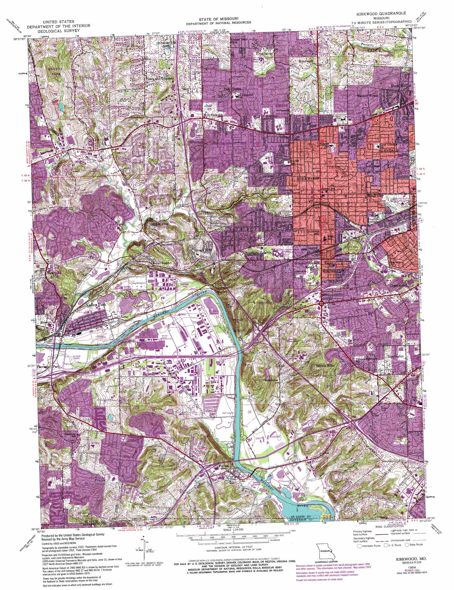
Kirkwood Topo Map Missouri
To zoom in, hover over the map of Kirkwood
USGS Topo Quad 38090e4 - 1:24,000 scale
| Topo Map Name: | Kirkwood |
| USGS Topo Quad ID: | 38090e4 |
| Print Size: | ca. 21 1/4" wide x 27" high |
| Southeast Coordinates: | 38.5° N latitude / 90.375° W longitude |
| Map Center Coordinates: | 38.5625° N latitude / 90.4375° W longitude |
| U.S. State: | MO |
| Filename: | o38090e4.jpg |
| Download Map JPG Image: | Kirkwood topo map 1:24,000 scale |
| Map Type: | Topographic |
| Topo Series: | 7.5´ |
| Map Scale: | 1:24,000 |
| Source of Map Images: | United States Geological Survey (USGS) |
| Alternate Map Versions: |
Kirkwood MO 1940 Download PDF Buy paper map Kirkwood MO 1940 Download PDF Buy paper map Kirkwood MO 1954, updated 1959 Download PDF Buy paper map Kirkwood MO 1954, updated 1967 Download PDF Buy paper map Kirkwood MO 1954, updated 1969 Download PDF Buy paper map Kirkwood MO 1954, updated 1975 Download PDF Buy paper map Kirkwood MO 1954, updated 1982 Download PDF Buy paper map Kirkwood MO 1954, updated 1993 Download PDF Buy paper map Kirkwood MO 2012 Download PDF Buy paper map Kirkwood MO 2015 Download PDF Buy paper map |
1:24,000 Topo Quads surrounding Kirkwood
O'Fallon |
Kampville |
Saint Charles |
Florissant |
Columbia Bottom |
Weldon Spring |
Chesterfield |
Creve Coeur |
Clayton |
Granite City |
Eureka |
Manchester |
Kirkwood |
Webster Groves |
Cahokia |
Pacific |
House Springs |
Maxville |
Oakville |
Columbia |
Cedar Hill |
Belew Creek |
Herculaneum |
Valmeyer |
Waterloo |
> Back to 38090e1 at 1:100,000 scale
> Back to 38090a1 at 1:250,000 scale
> Back to U.S. Topo Maps home
Kirkwood topo map: Gazetteer
Kirkwood: Airports
Fabick Heliport elevation 131m 429′Fritschle Field (historical) elevation 133m 436′
Hermann II Heliport elevation 152m 498′
Steubs Field (historical) elevation 129m 423′
Weiss Airport (historical) elevation 132m 433′
Kirkwood: Crossings
Interchange 272 elevation 128m 419′Interchange 274 elevation 144m 472′
Interchange 275 elevation 127m 416′
Interchange 276 elevation 137m 449′
Interchange 277A elevation 172m 564′
Interchange 277B elevation 195m 639′
Interchange 278 elevation 172m 564′
Interchange 279 elevation 181m 593′
Interchange 3 elevation 189m 620′
Interchange 5A and 5B elevation 141m 462′
Interchange 7 elevation 181m 593′
Interchange 8 elevation 159m 521′
Interchange 9 elevation 197m 646′
Kirkwood: Parks
Buder Park elevation 125m 410′Love Park elevation 137m 449′
Kirkwood: Populated Places
Barretts elevation 156m 511′Country Life Acres elevation 202m 662′
Crestwood elevation 189m 620′
Crystal Lake Park elevation 185m 606′
Des Peres elevation 186m 610′
Fenton elevation 132m 433′
Glendale elevation 179m 587′
Huntleigh elevation 169m 554′
Keyes Summit elevation 162m 531′
Kirkwood elevation 201m 659′
Meacham Park elevation 184m 603′
Oakland elevation 187m 613′
Osage Hills elevation 186m 610′
Ozark View elevation 171m 561′
Peerless Park elevation 125m 410′
Rock Hill elevation 161m 528′
Sappington elevation 182m 597′
Sunset Hills elevation 188m 616′
Town and Country elevation 178m 583′
Twin Oaks elevation 181m 593′
Valley Park elevation 130m 426′
Warson Woods elevation 163m 534′
Windsor Springs elevation 191m 626′
Woodhine Heights elevation 193m 633′
Kirkwood: Post Offices
Crestwood Plaza Post Office elevation 190m 623′Des Peres Post Office elevation 188m 616′
Fenton Post Office elevation 130m 426′
Kirkwood Post Office elevation 195m 639′
Manchester Meadows Post Office elevation 141m 462′
Sappington Post Office elevation 198m 649′
Valley Park Post Office elevation 129m 423′
Kirkwood: Streams
Fenton Creek elevation 120m 393′Fishpot Creek elevation 122m 400′
Glaize Creek elevation 137m 449′
Grand Glaize Creek elevation 121m 396′
Sugar Creek elevation 131m 429′
Kirkwood digital topo map on disk
Buy this Kirkwood topo map showing relief, roads, GPS coordinates and other geographical features, as a high-resolution digital map file on DVD: